
Oxbow Falls Park


Location: South of the hamlet of Clockville; Town of Lincoln; Madison County; New York.
Maps: Google Map; Topographic; Interactive map; Park Brochure
GPS Coordinates:
- Falls on Clockville Creek adjacent to the road: N 43.02862 / W 75.74152
- Parking area: N 43.02806 / W 75.74129
- Second waterfall: N 43.02777 / W 75.74371
- Third waterfall: N 43.02752 W 75.74426
- Bridge at bottom next to small drop on first waterfall: N 43.02993 / W 75.74361
Directions: From I-90:
- Take exit 34 for NY-13 toward Canastota/Oneida.
- Turn left onto NY-13 (N Peterboro St) and continue through Canastota and south.
- After about 1.3 miles it becomes Oxbow Rd. Continue south for 2.5 miles.
- See the Park Golf Course entrance on your right. Pass it and keep going south.
- Just around the bend, there will be a pullover on the right. You can park here, but head just a bit further south to a small lot at the side of the road.
Use Google Maps.
Parking: There are two places to park at the falls: the pullover off of Oxbow Rd and the gravel lot just south of there near the trailhead. A larger parking space can be find north, which would give you a longer hike up to the falls. See the map below for locations.
Weather
Information / Accessibility / Accommodations
Number of falls: 3 waterfalls.
Size/Types: 2 of the 3 waterfalls are mostly seasonal, being reliably dry by summer. Most guides will mention one of the park’s falls being 100 ft in height. This is likely a generous measurement, and you definitely will not see the full extent of any of these waterfalls without using a drone. All of the waterfalls here are multi-tiered, consisting of 10 or more drops, linked by smaller rapids and tumbling over boulders. So when the heights are measured, it’s mostly referring to the full stretch of the falls tumbling down the steep escarpment, and not one single drop that’s visible all at once.
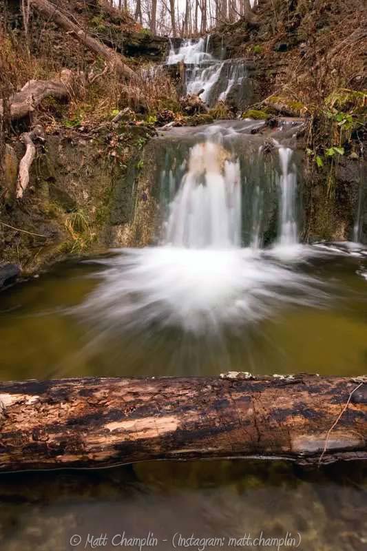
The first of the falls, by Oxbow Road, is on Clockville Creek. It’s a narrow, multi-tiered falls that stretches about 600 ft in length. Two of its drops are over 10 ft in height. Portions of it are viewable from the road, but it is largely inaccessible. A smaller 3ft tall drop is visible from the footbridge at the bottom.
The next two falls are formed by tributaries parallel to each other. The first one has a 50 ft steep cascade emerging from below the footbridge, then it tumbles over boulders and over smaller shelves as it makes its way down the escarpment to merge with the second tributary.
On the second tributary, just a few hundred feet from the first, is a more narrow cascade, which very well may be the one often referred to as 100 ft tall. It features a 25 ft tall drop about 1/3 of the way down, but it’s difficult to get a view from the trail. Across its 600 ft run down the escarpment, it tumbles down in some form or another, being the most continuous falls in the park.
Best time to visit: Early spring when the ground is still wet and the trees have no or minimal foliage. Avoid summer unless it has been raining for days prior.
Flow: Low. All but one will likely dry up by summer, and that one may just be a trickle.
Waterway: Clockville Creek and tributaries. Clockville Creek originates 2 miles to the south at Nichols Pond County Park. After the falls, it continues north through Clockville. It then heads east 2.6 miles to Cowaselon Creek in Lenox. From there, Cowaselon Creek flows north for 2.8 miles, then swings west, passing north of Canastota, where it travels in a straight line through an engineered canal (known as Douglas Ditch) for 5 miles northwest, then turning 90 degrees north (becoming Canaseraga Creek) for a short jump to Lake Ontario at Lakeport.
Time: About 30 minutes to see the falls from above. A few hours if you want to hike to the bottom or perhaps go off trail and see more of the falls.
Seasons/Hours: Daylight hours, 7 days a week.
Admission: Free (disc golf course is free too).
Handicap Accessibility: None.
Pets: Allowed on a leash.
Accommodations:
- 2 miles of trails for hiking, snow-shoeing, cross-country skiing
- 18-hole disc golf course
- Open pavilions
- Softball field
- Restrooms (summer only)
- Picnic tables and grills
- Food and shops can be found in Canastota to the north.

Description
Oxbow Falls Park is located on the northern edge of the Helderberg Escarpment, a geological formation that dates back over 350-400 million years to the Devonian period. The escarpment forms a steep cliff of over 100 ft creating 3 waterfalls within the park and a beautiful view of the lowlands to the north. On a clear day, one can easily see Oneida Lake and often Lake Ontario in the distance. The three narrow waterfalls plunge down the top of the escarpment and tumble down various shelves, boulders, and accumulated debris meeting up further north in the park. It’s certainly a treat to have 3 tall waterfalls in such close proximity to one another. They are a breeze to get to from the parking area at the south end of the park, but because of the relatively primitive trails and natural tree growth, they are largely obstructed. They are also so lengthy in their run, that it’s virtually impossible to catch them in their entirety without the aid of a drone. Still, this does make for some wonderful off-trail exploring opportunities if you are careful.
At the north end of the 1280-acre park is a popular 18-hole disc golf course and eco-friendly restroom.
History
In 1792 John and Joseph Clock (from the Mohawk Valley) settled near the village. They were assumed to be the 3rd family to settle here, with the previous 2 families lost to history. Joseph settled and constructed a sawmill (likely near the present day intersection between Oxbow and Cottons Roads). For a time the emerging village was known as Shippeyville, after a tavern keep named Shippey.
Clockville Creek powered several sawmills, a grist mill, a cheesebox factory, a rake factory, plaster mill, among others. I could not find any evidence of a mill within the vicinity of the park.
Madison County was formed in 1806 and the town of Lenox was formed in 1809. It later became the Town of Lincoln.
Hiking / Walking Trails
Difficulty: Easy to moderate. There are over 2 miles of trails and to catch a few of the 3 falls from above, one does not have to hike the whole way. Note that the wooden trail sign at the park seems to be quite out of date and lacks several of the trails.
Markings: Colored blazes. You will want to stick to the Blue and Orange trails here.
Distance: About 0.2 mile to check out the falls from above. About 1 mile loop down below the falls and back.
Description:
- From the parking area, head north up the road. With the railing behind look and listen for the first falls. You should be able to catch a glimpse of part of it through the trees.
- From the southern parking lot follow the Blue trail north towards the restroom.
- Pass the restroom and then head left of the pavilion. You will soon find the escarpment on your right.
- At about 0.1 mile, you will approach the intersection with the Orange trail. Take a left on this trail keeping the escarpment on your right.
- Shortly after, you will walk on a footbridge over the second falls and can see it from above.
- Continue on with the escarpment on your right. Soon you will be able to spot the third falls. Another footbridge will pass over that tributary.
- The trail will loop north and descend with one long switchback, bringing you to the bottom of the tributaries at about 3/4 of a mile. From here you may be able to spot those two falls from a distance.
- Continue on the Orange trail and you will find yourself at an intersection and footbridge. The footbridge should offer a view of a small waterfall on Clockville Creek. Continuing in this direction will lead to the Yellow trail and to the disc golf course.
- Continue on the Orange trail to loop back south and uphill to the blue trail at the mile mark.
Map: Interactive.

Oxbow Falls Interactive Map
Oxbow Falls Park Media
Oxbow Falls Park Videos

Contributor Photos & Art


At this time I have not been able to get out to this site and photograph yet. In the meantime, those with suitable photos or original works of art, who would like to be featured here, please contact me. Photos, paintings, and illustrations would be subject to quality review, and not all will be accepted. Your work can be accompanied by a link to your site/store/Instagram.
Who to Contact
Madison County Planning Department
315-366-2376
