
Point Gratiot Park


Location: On the east end of Lake Erie; in the city of Dunkirk; town of Dunkirk; Chautauqua County; New York.
Maps: Google map; Topographic; Interactive map
GPS Coordinates:
- South entrance: N 42.48402 / W 79.35766
- East entrance: N 42.48816 / W 79.35357
- North entrance: N 42.49241 / W 79.35541
Directions: From east and west:
- Follow NY-5 to Dunkirk
- Turn onto Point Dr W and follow it to Park Dr.
- Turn north onto Park Dr and follow it to the lake where it turns to the right and becomes W Oak Street.
Use Google Maps.
Parking: There’s a small gravel parking area at the south end of the park right up against the beach off of Park Dr. Three massive parking lots can be found in the center of the park off of W Oak St.

Weather
Information / Accessibility / Accommodations
Seasons/Hours: Open daily, from dawn until dusk.
Admission: Free.
Best time to visit: Spring through summer.
Time: Several hours for a picnic and to walk along the shoreline. Time it at sundown to see the sunset from the beach.
Handicap accessibility: There is a level paved pathway along the west edge of the park with beautiful views of the lake. Restrooms are accessible. The pavilions have gravel pathways leading from the parking area as of 2023.
Pets: Allowed, on a leash, with proof of vaccination.
Swimming: Swimming is allowed in the guarded swimming area when a lifeguard is on duty. (usually Memorial Day through Labor Day)
Boat launch: No trailer boat launching here. If you need to launch, head east to Dunkirk City Pier or west to Barcelona Harbor. You can hand launch easily from the south end.
Accommodations: Aside from views of the lake, there are:
- Picnic tables, grills, pavilions
- Swimming
- Baseball diamond and volleyball court
- Playground
- Canoeing/Kayaking (hand launch from the shore)
- Restrooms
There are several restaurants and shops to the east, just down Lake Shore Dr at Central Ave.


Description
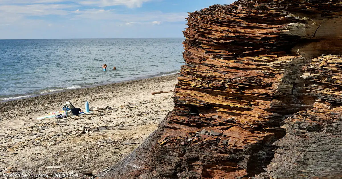
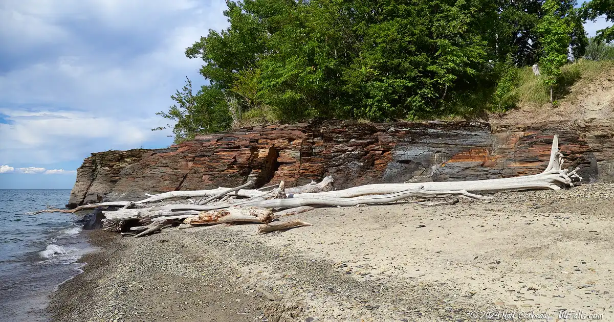
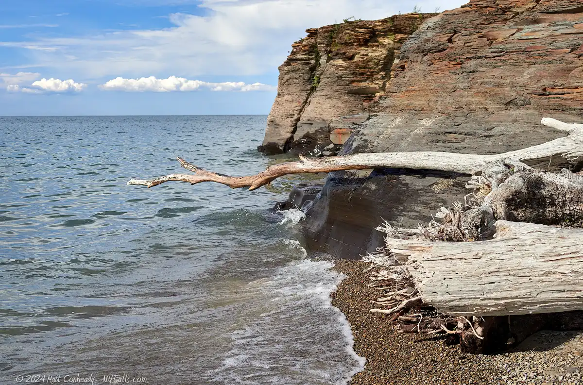
Point Gratiot Park is the crown jewel of Dunkirk’s park system. The 55-acre park on the west side of the city offers stunning views of Lake Erie surrounded by lush green space. The park’s serene beach faces westward, which is the perfect angle to catch the summer sun setting over the horizon. To the north, jagged shale cliffs jut out from the park past the beach and into the lake, creating a unique and photogenetic setting to explore.
The park above the beach is well developed, spotted with mature trees and sprawling lawns that provide an ideal backdrop for picnics, leisurely walks, and relaxation by the water. Families and individuals alike can enjoy the playgrounds and picnic spots, while the volleyball courts and walking trails cater to those seeking activity amidst nature’s beauty. The paved walkway along the lake is lined with benches making relaxing views accessible to all, and picnic tables, grills and plenty of shade make it the perfect hangout or cookout spot.
Point Gratiot Park is a hub of community life, hosting a variety of events throughout the year that celebrate culture, music, and local flavors. When we visited in late August, the park was full of the sights, sounds, and aromas of family cookouts. While we were out-of-towners amidst their personal gatherings, we couldn’t help but feel at home in the park.
The historic lighthouse north of the park adds a touch of maritime charm, drawing photographers and history enthusiasts alike.

History
“Gratoit” is pronounced “gra·shuht”.
Point Gratiot, which serves as the western point of Dunkirk Harbor, was named after General Charles Gratiot (1786 – 1855) who was a Brevet Brigadier General and Chief of Engineers in the U.S. Army Corps of Engineers during the War of 1812. His notable contributions include overseeing fortifications and infrastructure projects during the war. Despite facing challenges later in his career, including financial difficulties that led to his resignation from the army, Gratiot’s work in military engineering and fortifications had a lasting impact on American military infrastructure.
While British and French ships undoubtedly used Dunkirk’s natural harbor prior to the 1800’s, what is now the city was largely dense and unbroken forest. It wasn’t until 1808 when the first white settler, Timothy Goulding, arrived and built his house near the area of the park. His land ownership extended into the point. The following year, his brother-in-law, Solomon Chadwick settled along the harbor. For the next decade the harbor was known as Chadwick Bay. Chadwick sold his land to Daniel Greene Garnsey (1779 – 1851) a Congressman from Dunkirk, and hence it became known as Garnsey Bay for a time.
The park came into existence in 1839 when Russel H. Nevins, a prominent New York City real-estate broker and former president of the New York Stock Exchange, leased the park to the City for 1¢ per year for a term of 99 years. A grand pavilion, was constructed in 1899.


Hiking / Walking Trails
Difficulty: Easy (along the paved park pathway) to moderate (if you walk along the sand/stone beach).
Distance: Our recommended walk along the length of the park and up the beach is about 1.2 miles.
Markings: Paved pathway and then a beach bordered on one side by the lake, and shale cliffs on the other.
Description: A level paved walkway parallels the lake and Park Drive on the west side of the park. It runs the full length of the park and offers views of the lake. To optimize your walk, pick up the trail on the north end of the park and head south.
In the middle of the park, west of the two pavilions and the volleyball court, are stairs off that pathway that serve as a shortcut to the beach, although it may be raised in the off-season.
At the south end of the park, the path passes through a gravel parking area at the beach. You can enter the beach here or continue on the path a few hundred feet more to its end, then follow the road west to the beach. Walk north up the beach (with the lake on your left) until you can go no further past the shale cliffs. Do not attempt to climb the cliffs or even swim in this area.
Map: Check out the interactive map.
Point Gratiot Park & Beach Interactive Map
Fishing
Fishing is allowed in the park. Fish Lake Erie from the beach.

Interesting Stuff
Point Gratiot Geology
- The point extends about one kilometer into Lake Erie, forming the western end of a natural harbor at Dunkirk. This geological feature sits atop the Upper Devonian Dunkirk Shale formation, characterized by its black shale that formed in an oxygen-deprived environment within the Appalachian Foreland Basin during the Acadian Orogeny. Atop the Dunkirk Shale, Pleistocene-era glacial deposits create a noticeable gap in the geological record that encompasses around 375 million years.
Dunkirk Lighthouse
- Also known as Point Gratiot Lighthouse, is a historic beacon located north of the park at the apex of Point Gratiot. This venerable structure has been guiding mariners since the first tower was built in 1826, with the current tower constructed in 1875-1876. The lighthouse stands approximately 61 feet tall and is constructed of hand-carved ashlar limestone, making it a striking architectural feature against the backdrop of the lake. The Victorian-style keeper’s house, which was built in 1875, has been meticulously preserved and now serves as a museum.

Photography Tips
Shale Cliffs
- The shale cliffs at the north end of the beach offer striking contrast with the sandy beach and blue surrounding waterscape. Their jagged, crumbling structure, combined with stripes of cool gray, bright rusty hues, and bold black stripes make for great foreground elements to lake scenes. Photographers should not miss them.
- Water levels may be high and that means less beach between you and the cliffs. Bring a wide angle lens so you can fit more of the scene in.
- Do not climb the cliffs. Shale crumbles easily and the cliffs are very unstable. Waves crashing up against the cliffs can easily cause injury, so for your safety, do not enter the water here.
Cars
- The annual Dunkirk Harbor Cruise show takes place the first week in July and features well over 500 cars, including hot rods, muscle cars, classics, customs, trucks, rat rods, wild vans, and more. The colors and craftsmanship make for a photography adventure of its own.
More tips
- See the Articles and Message Board sections for more photography tips.
Nearby Waterfalls


More Lake Erie Parks & Beaches
Find a new summer hangout spot or place to swim in our comprehensive guide to Lake Erie Parks and Beaches in New York State.
Who to Contact
City of Dunkirk Parks
716-366-3262
[email protected]
