
Wilsey Creek Falls (Schoharie Creek Preserve)


Location: On the north end of Schoharie Creek Preserve; town of Charleston; Montgomery County; New York.
Maps: Google Map; Topographic; Interactive map.
GPS Coordinates:
- Roadside parking north of Wilsey Creek: N 42.82276 / W 74.26424
- Parking at Schoharie Creek Preserve: N 42.81724 / W 74.26591
- North Trailhead: N 42.82107 /W 74.26553
- Butler Falls: N 42.82242 / W 74.26423
Directions: From Schenectady:
- Take NY-159 W for 10.5 miles.
- Turn left onto NY-30 S and after 2 miles it’ll become Burmans Corners Rd. Proceed for another 1.5 miles.
- At Burtonville, make a right onto Burtonville Rd and follow it for just under a mile.
- Make a right onto Butler Rd.
- Shortly after, you will pass the Preserve entrance on your left. You can park here or…
- Continue north, passing over a bridge, then immediately on your right will be a roadside parking area just north of the bridge.
Use Google Directions.
Parking: The preserve’s main parking area to the south has room for about 10 cars. Getting to the falls from here requires hiking the loop trail, but it’s not long at all. There is a parking area just north of the bridge on Butler Rd with room for 3 or 4 cars.
Weather
Information / Accessibility / Accommodations
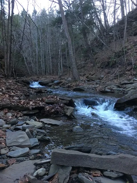
Number of falls: 2 of decent size. Several more small falls upstream.
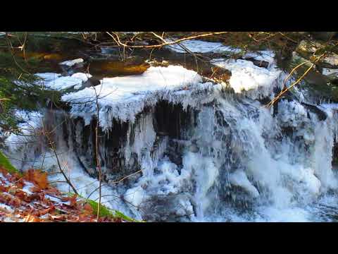
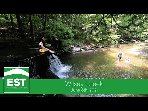
Size/Types: The largest waterfall east of the bridge is commonly called Butler Falls and is roughly 20 ft tall. Just west of the bridge is a 5 ft cascade. Upstream from there are about 4 smaller waterfalls.
Best time to visit: The falls have more water and are easier to see from a distance if you visit in early spring before foliage takes over.
Flow: Moderate.
Waterway: Wilsey Creek, which originates a few miles west of here. Just below these falls it empties into Schoharie Creek, which takes it north 9 miles to the Mohawk River, just west of Amsterdam. The Mohawk flows east through Schenectady and then meets the Hudson at Troy, north of Albany. The Hudson flows south to NYC and empties into the Atlantic Ocean.
Time: 30 to 45 minutes to hike the short loop in the preserve and check out the falls safely.
Seasons/Hours: Daylight hours, 7 days a week.
Admission: Free.
Handicap Accessibility: None.
Pets: Allowed on leash.
Accommodations: Just trails.

Description
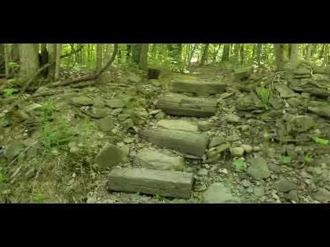
Located along the north border of the 198-acre Schoharie Creek Preserve in the town of Charleston, is a short stretch of Wilsey Creek that descends into the Schenectady Creek Valley, creating a series of waterfalls along the way. The tallest of these is on the east side of Butler Rd, and commonly known as Butler Falls. At 15-20 ft in height, it’s the largest of the waterfalls here, and the most difficult to see. Upstream there are a few more small waterfalls in a series leading about a tenth of a mile upstream. None of the waterfalls are on the official trail loop, and signs discourage visitors from descending the steep gorge to wade in the water, but people do, and more than a few do this in summer. Well worn unofficial side trails lead down to the creek in various spots. I urge anyone going off trail to use caution, brush up on your safety knowledge, and do so at your own risk.
The preserve itself features a 1.3 mile loop through wooded terrain and has a moderately challenging incline. Aside from the falls, there are beautiful views of Schoharie Creek and the valley from the east side of the trail loop. Off trail, some have found the remnants of old barns and farm equipment; traces of the farms that once occupied the property.


History
The land was donated to the Mohawk Hudson Land Conservancy in 1988 by Dr. Lester Citrin and Dr. Clifford Tepper.
It was abandoned farmland at the time. A farmhouse once stood west of Butler Rd, just north of the main parking area. Another stood just south of Buttonville Rd.
Butler Road, and thus Butler Falls likely gets its name from the J.P Butler Family, who owned farmland to the north of here. Prior, it was marked on maps as Mill Brook.
Hiking / Walking Trails
Difficulty: Moderate if you stick to the trail. There are some steep inclines, but the trail is not long at all. The challenge goes up if you are planning on going off trail to walk up the creek and get a close look at the waterfalls.
Markings: Very well marked trail with signs and blue circular markers for the main loop. Several well-worn paths lead off trail toward the creek.
Distance: The loop is about 1.3 miles in total.
Description: If you park on the pullover off of Butler Rd (north of the bridge) there is a trail on the right side of the lot that will get you close to Butler Falls. For a time, people were able to climb down below the falls from here, but I am unsure if this is still the case. You may be able to catch a view from the other side of the creek, from along the trail.
Head to the road and then south over the bridge and along the road for about one 10th of a mile. Look for the trail signs on either side of the road. When you find them, you have two choices: Left/east leads towards Schoharie Creek, passing by Butler Falls. You may be able to get a view of the falls depending on foliage. Further along, there are views of Schoharie Creek. Going right/west from the road will parallel Wilsey Creek. Along the way there are some views of the falls from just off trail as well as a few steep paths leading down to the creek.
Either direction you take will loop back if you stick to the main trail.
Map: Interactive.

Schoharie Creek Preserve Interactive Map
Wilsey Creek Falls (Schoharie Creek Preserve) Media
Videos
Contributor Photos & Art
At this time I have not been able to get out to this site and photograph yet. In the meantime, those with suitable photos or original works of art, who would like to be featured here, please contact me. Photos, paintings, and illustrations would be subject to quality review, and not all will be accepted. Your work can be accompanied by a link to your site/store/insta.
Interesting Stuff
Cemetery
At the corner of Gombar and Butler Roads is an old overgrown cemetery with stones dating back to 1803.
Concrete slab
There’s a concrete slab at the corner of Butler and Burtonville Roads. This was the foundation for an 1800s-era one-room schoolhouse.
Who to Contact
Mohawk Hudson Land Conservancy
518-436-6346
