Conklin Gully


Location: Within the DEC’s Hi Tor Wildlife Management Area; North of the village of Naples; Town of Italy; Yates County; Finger Lakes Region; New York.
Maps: Google Map; Topographic; Interactive map.
GPS Coordinates:
- Parking lot: (N 42.63497 / W 77.36762)
- Trailhead: (N 42.63502 / W 77.36718)
- Angel Falls: (N 42.63156 W 77.36188)
Directions: From NY-21 in the village of Naples, head north out of the village and turn right onto NY-245. 245 will turn left, right as it approaches the Hi Tor Area. About a mile and a quarter after that turn, the parking area will be on your right. The parking area has two entrances. Just behind it is Parrish Hill Rd, so if you hit that, you’ve gone too far.
Parking: There’s a dirt and gravel parking area off of CR-245. It can hold about 10-12 cars. Alternate parking can be found off of Parrish Hill Road (coming from NY-245) near the 3rd bend. It’s a dirt road that leads into the woods for a few hundred feet. Many people just park on the side of 245 at this point. This leads to the north rim trail.
Weather
Information / Accessibility / Accommodations
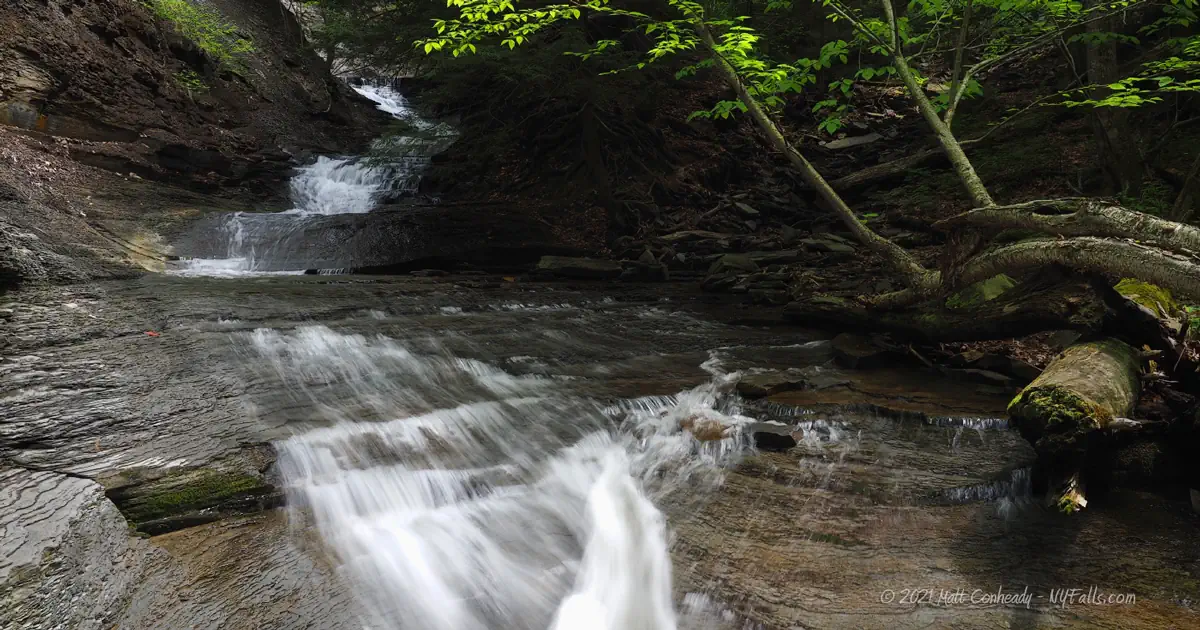
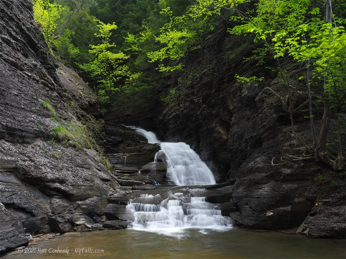
Number of falls: 5 large waterfalls. There are several smaller cascades along the hike. Probably 15 in total. Angel Falls is a large seasonal runoff cascade and only flows after high rain/snowmelt–it’s easily missed.
Size/Types: Angel Falls, when flowing, is about 120 ft tall. The three remaining large falls (from downstream up) are estimated at 30, 20, 25,15, and 50 ft tall. The smaller falls going up the gully range from a 3 to 8 ft tall.
Best time to visit: Spring and Fall. Winter can be dangerous with ice and falling rocks.
Flow: Low to moderate. The creek will dry up by mid-summer.
Waterway: An unnamed tributary to Naples Creek, which is the southern inlet to Canandaigua Lake.
Time: Several hours. Take your time climbing and don’t rush for obvious safety reasons.
Seasons/Hours: The Hi Tor Wildlife Management Area has no restricted hours or times. For safety, visit in daylight with plenty of time to make your descent before dark.
Admission: Free.
Handicap Accessibility: None. This is a very difficult stream hike requiring climbing and traversing the creek.
Pets: Pets are allowed in the WMA, but you would be foolish to take them on this dangerous hike. If you must bring your pet everywhere you go, take one of the uphill rim trails, not the gorge trail and bring some water in a dish because the ascent can be exhausting.
Accommodations: Parking and trails. If you need food, restrooms, or anything else, the village of Naples is a 5 minute drive south.
Description
Also known as: Parish Glen
The 6,800 acre Hi Tor Wildlife Management Area sits primarily east of the village of Naples on the south end of Canandaigua Lake. Consisting of steep wooded terrain, lowland marsh, forested wetland, and some grassland, it also houses some of the area’s most beautiful waterfall-filled gorges. Along with Clark’s Gully, which is across the valley just north of here, Grimes Glen, and Tannery Creek, the Naples Valley region is quite bountiful for the Finger Lakes waterfall enthusiast. That is if you are up for getting your feet wet.
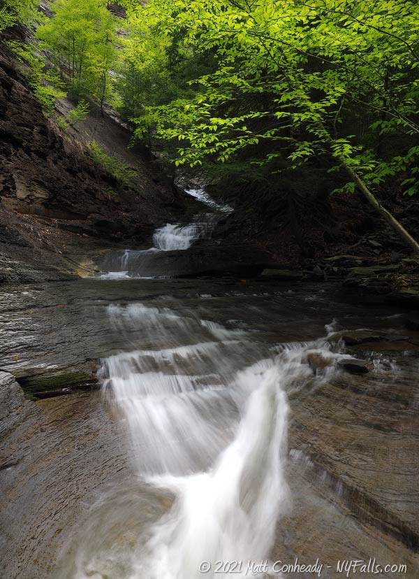
While there are trails that follow the north and south rim of the gorge, offering occasional views of the cascades below, a hike right up the gorge, with feet in the cool waters and hands gripping the dirty shale rock, are why many visit this natural ravine. Even if one chooses to spot the falls from the rim, the hike is strenuous, with about 3/4 of a mile with a steep incline to make your way up the hill. For those taking the gorge route, there are numerous slippery climbs and risky scrambles. One has to want and expect to get wet and dirty to even have a chance of getting far. While some ropes have been left by previous hikers, they are often compromises in safety. Only the most experienced waterfall hikers should consider pushing their limits, and only with a partner, and following safety advice.
On a previous visit I found one man attempting to climb up the gorge on his own, well not really alone — he had a young baby strapped to his back, with one hand grasping a GoPro on a selfie stick. I can’t stress enough how utterly stupid this is. In 2008, a climber fell 150 ft into the gorge, requiring rescue teams to risk their lives to extract him.
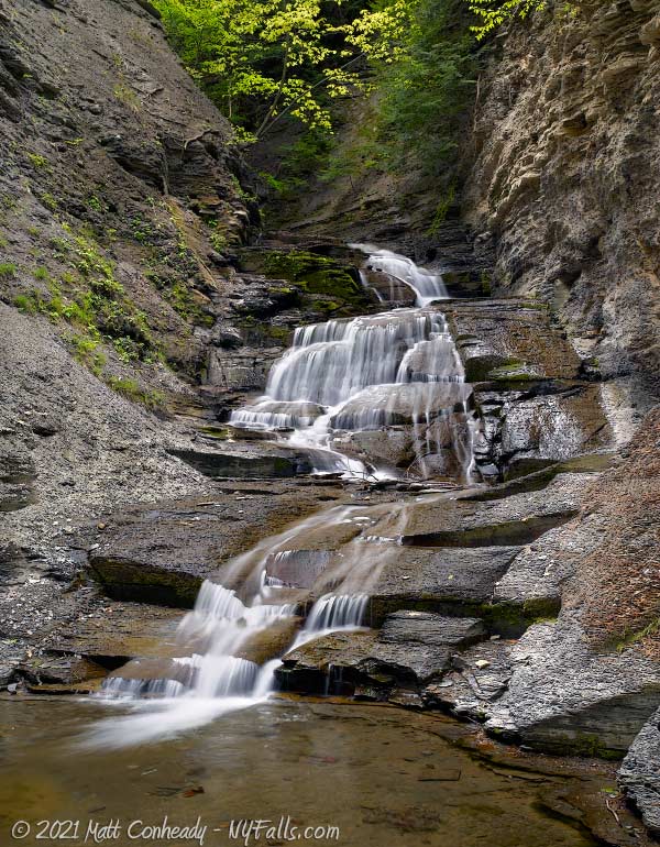
For those who can and do make the journey, there are 5 large and unique gorgeous waterfalls to see, as well as several pristine cascades to enjoy along the way. With virtually no development in the Hi Tor WMA the settings are all natural, the water runs clear, and no traffic or civilization can be heard from within. While I highly recommend it to advanced hikers for its beauty, I also strongly caution folks to take this hike seriously, perhaps getting a taste first from the rim trails, which offer breathtaking views as well.
When planning your visit, you have a choice… high flow, which may mean a chance to see the 120 tall Angel Falls flowing, but face a significantly more challenging hike. Or wait for drier conditions, with less water to fight, better foot-grip when climbing, yet a chance that more falls run dry. It depends on your skill level. Either way, Conklin is best explored over multiple trips and under a variety of conditions.
History
Note that the spelling of the family name Parrish seems to vary in the historical record. Spelled with both 1 and 2 “R”s seems to be a source of confusion when connecting family trees.
Jasper Parrish, who was an interpreter for General John Sullivan during the US campaign against the Iroquois tribes, settled in Canandaigua, but records show he was involved in the founding of the Naples township.
The Parrish family, led by Samuel, Reuben, and Levi were some of the first settlers of Naples. Descendant and first white child born in the town, Elisha Parrish seems to have settled on the land here and constructed a sawmill. He also served as Poormaster for the fledgling settlement and taught winter school. The glen, formerly known as Parrish Glen, was most likely named after him. The Conklin Family owned the land surrounding the glen after the Civil War.
Hiking / Walking Trails
Difficulty: The rim trails are moderate to difficult. The slope is steep and you will need to maintain this for at least a half mile. Getting views of the falls below means you will be taking some risks getting close to the cliff edge.
The gorge route is not an official trail and is very difficult. If the creek is flowing, expect to get wet. Climbing several of the large falls, even if ropes are to be found, is still tough given their restricted placement, weathering, and slippery condition of the rocks. Only the most advanced climbers should attempt this. If you don’t make it all the way up and to the junction with the rim trails, you may find climbing down to be more difficult than going up.
Markings: None.
Distance: About 1.1 miles one way up the gorge. The way back can be more depending how you want to complete the loop.
Description: The path you decide to take, and how far you want to go depends on several factors. Water height and the conditions of the creek may impede the creek walk. Most visitors take the north rim, which is a pretty defined path through the wooded hillside and offers occasional views of the gorge bellow. From the parking area, head down to the creek and either cross it, or head out to the road and cross the bridge there. There are no rails atop the gorge, so some spots mean you need to get awfully close to the edge to get a decent view. The north rim trail crosses the creek and loops around to the south rim to get back to the parking area.
For those wanting to creek walk up the gully, be prepared to get wet and dirty. When looking at some books and online guides for this I felt they maybe were too specific, mentioning log jams and rock falls as landmarks. Well, these things change flood after flood, and I’ve seen people carve out new side trails to avoid some obstacles. So, I’ll spare you those details. From the creek bed at the trail head, there’s only one way to go: up. You will climb waterfall after waterfall, including 5 large falls. The 50 ft falls about a mile in is where you should stop. You’ll recognize it because there’s no way any sane person would attempt to climb it. Keep in mind, you don’t NEED to climb all the falls. Additionally you have to consider you may have to climb back down them all as well, which I find to be worse than the going up. Make smart choices and be safe.
Map: Interactive.
Conklin Gully Interactive Map
Conklin Gully Media
Videos

Photography Tips
Silky Water Effect
- To get that smooth cotton-candy look to the falls, you need to use a Neutral Density (ND) filter on your lens. The ND filter will block some of the light from entering the lens without altering the color, and thus allows your shutter to stay open longer. This blurs the water and creates a soft white gloss to the foamy areas of the falls. Check out the article for all of the details.
Protect your Gear
- This hike is a wet and dirty one. Keep your gear packed away in a waterproof pack when hiking.
More tips
- See the Articles for more photography tips.
Who to Contact
DEC Region 8 Avon Office
(M-F, 8:30AM – 4:45PM)
(585) 226-2466
[email protected]