West Italy Hill Falls


Location: On West Italy Hill; town of Italy; Yates County; New York.
Maps: Google Map; Topographic; Buy FLT Map (B2); Interactive map.
GPS Coordinates: Approximate location of large waterfall: (N 42.62471 / W 77.29143)
Parking: (N 42.62640 / W 77.28150)
Directions: The closest trailhead is located off of Italy Valley Rd, just north of the hamlet of Italy.
From Naples: Head southwest on Main Street, which will become NY-53S as you leave the village. Continue on NY-53S for 1.1 miles.
Turn left onto CR-21 (Italy Valley Rd) and follow for 7.7 miles into Italy Valley.
Look for a white barn on your right. Shortly after, the road will cross over Flint Creek. Right after it crosses, there will be a gravel parking area on your left. A FLT trail register will be near this lot.
Use Google Maps.
Parking: Gravel lot on the west side of Italy Hill Rd. Space for several cars.
Weather
Information / Accessibility / Accommodations
Number of falls: 1 large waterfall, some smaller ones deep in the gorge.
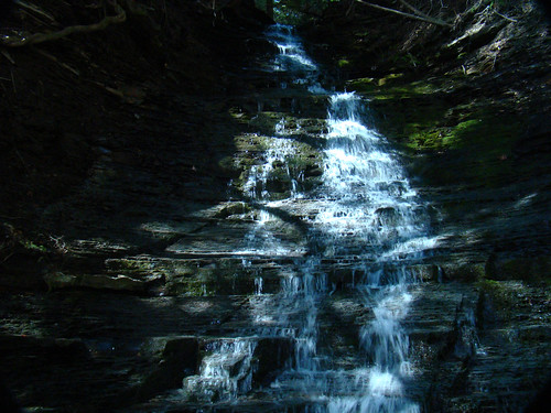
Size/Types: These falls are not very well documented as the view from the rim only paints a partial picture. There’s a significant lower falls, estimated at 5-8 ft high, and an upper falls that’s over 30 ft. Both are chute-like cascades.
Best time to visit: Spring.
Flow: Low. It will dry up by mid-June.
Waterway: An unnamed tributary to Flint Creek. Flint Creek starts up in the hills south of the High Tor WMA, east of Naples, heads north through Italy Valley and then through what used to be Potter Swamp. It’s now naturally irrigated farmland that diverts Flint Creek and hillside tributaries into an unnatural grid. The creek continues north through Gorahm, past Seneca Castle, and all the way up to Phelps‘ own waterfalls. Just north of Phelps it merges into the Canandaigua Outlet. The outlet heads north where it meets the Erie Canal at Lyons. Before the Canal was constructed, the Outlet would have merged with Ganargua Creek.
Time: A few hours.
Seasons/Hours: Year round.
Admission: Free.
Handicap Accessibility: None.
Pets: Allowed on the FLT. Pets need to be on a leash in public.
Accommodations: Trails, trail register, leanto nearby.
Description
West Italy Hill Falls has been a mysterious curiosity for the NYFalls community for years. Trail guides, including the Freeman waterfall guide mention it as a site to be seen from a distance while passing by on the Bristol Hill Branch of the Finger Lakes Trail (FLT). Apparently, after one of the most strenuous uphill hikes in the region, one may get a chance to see the top of the falls from the trail, IF the surrounding foliage allows, and IF it happens to be flowing. Only the dedicated waterfallers gave it a shot.
Some went a step further, hiking directly up the wild and vernal ravine, ropes, mud, and blood the whole way. Not something I feel anyone would recommend, a creekwalk, well, more like a creekclimb up the ravine from below is the only way to experience the falls and see them in completeness. Reports vary, but aside from the large falls seen from the FLT hike above, first reported to be around 30 ft tall–possibly much larger, there is a smaller falls near the bottom. A few more slides and chutes dot the young glen, amongst the numerous downed trees, brush and mud. When flowing, water rushes down quickly, creating quite a stir. In a geologic sense, it’s a newly formed ravine, not having a chance to cut deep, so it’s much like it’s flowing down a steep slide of exposed rock in the hillside.
This one is only for the seasoned waterfallers, looking for the ultimate challenge.
History
Italy was a part of the large Phelps and Gorham purchase following the American Revolution. After no settlers took interest in purchasing Italy plots from their land office, the whole tract was sold to Robert Morris and then to Pultney and Hornby.
The town of Italy was originally part of the town of Middletown, formed in 1789. Middletown is now named Naples. Italy was organized in 1815.
John Mower was the first settler, a land surveyor who made a more-or-less permanent camp in the valley in 1790. By 1795 he had a permanent home. William Clark and family (of Clark’s Gully) settled here in 1790.
The Seneca name for Flint Creek is Ah-ta-gweh da ga. Some records show the European name for the creek came from a man known simply as “Flint.”
Settlers were drawn to Italy Valley and Flint Creek for its consistent flow, constructing several saw and gristmills along this stretch. By 1800, the town had a population of 259. By 1850, that number grew to about 1700. In 2010, the number was 1,141.
Hiking / Walking Trails
Difficulty: Going up the FLT to see the large waterfall from the rim is very difficult. Can you climb stairs for an hour?
Going up the ravine itself is extremely challenging. You’ll need to be equipped to climb and have safety measures in place.
Markings: The FLT has various colored blazes. I wish I could say it’s as organized and well maintained as its maps imply. It is not. Red Blazes are what you are looking for to follow the FLT trail uphill and see the falls from the rim.
Distance: A mile, mostly uphill, to get to the point where you may be able to see the falls through the trees. You can continue on to the 2.8 mile point at the top of the hill for a nice view.
The creekwalk is about 2/3 of a mile. Steep climbing and some rope work all the way.
Description: The FLT Trail: from the parking area, follow the orange-blaze trail across the field toward the hill. The trail will start ascending through a series of switchbacks.
There are many old logging roads and other trails that bisect this one. Stay on the orange if you can.
Pace yourself. This one only gets steeper. As you reach the ravine, the switchbacks will diminish and you’ll be heading more straight along the ravine edge. If the falls are flowing, you’ll definitely hear it about a mile in. Try to spot it through the trees. You can turn around and head back or you can keep going to get to the top of the hill at Wood Hill Rd. There’s an open field with a hang glider launch point and nice views along the trail as you get close to the road.
Climbing up the ravine: I don’t recommend this. People I know have done it and don’t recommend it. It’s tough. It’s dangerous. You could get hurt.
A logging road leads down from the orange blazed trail to the base of the ravine. You can creek walk up from there. You will encounter a 5-8 ft waterfall first. If water levels are high, you may not be able to climb further. The ravine is not like nearby gullies. It’s straight up, filled with downed trees, branches and loose rock. The large waterfall is pretty much unpassable.
Map: Interactive.
West Italy Hill Falls Interactive Map
West Italy Falls Media
Videos
Coming soon…
Contributor Photos & Art
NYFalls Talk message board member Bremer posted this shot of the large falls from below. He climbed up the ravine AND THIS FALLS in 2011.
Who to Contact
Finger Lakes Trail Conference
585-658-9320
fingerlakestrail.org