
Salmon River Falls, Oswego County


Location: Within the Salmon River Falls Unique Area; near the village of Altmar; town of Orwell; Oswego County; New York.
Maps: Google map; Topographic; Unique area map; Interactive map.
GPS Coordinates:
- Salmon River Falls: N 43.54761 / W 75.94027
- Parking: N 43.54910 / W 75.94384
- Salmon River Dam: N 43.54471 / W 75.91938
Directions: From Syracuse area and points south head north on I-81 to exit 36 for the village of Pulaski. Turn right off the exit onto NY-13. Travel for 6 miles until you reach Cemetery Street (CR-22) in the village of Altmar. Make a left and follow CR-22 for 4 miles past the reservoir until you reach Falls Road where you will see a sign for Salmon River Falls.
Parking: Room for about 30 cars in a roadside lot off of Falls Road.
Weather
Information / Accessibility / Accommodations
Description
AKA: Salmon Falls
The Salmon River Unique Area is managed by the New York State Department of Environmental Conservation (DEC) and was created to protect a very popular tourist destination along with a wide variety of plant and animal life that is unique to this shale talus-based geology. Rare species such as the bird’s-eye primrose and the yellow mountain saxifrage grow here. The goal of this unique area is to recognize and begin to protect its unique habitats as well as provide a basis for building a network of trails that follow the river all the way to the village of Pulaski to the west. Its designation as a “unique area” takes into account a number of regular activities that the land is used for, such as hiking, ice climbing, fishing, trapping, hunting, and limited logging.
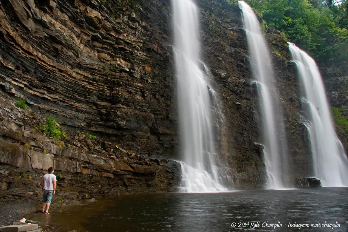
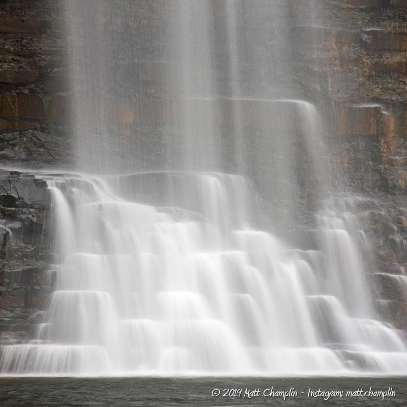
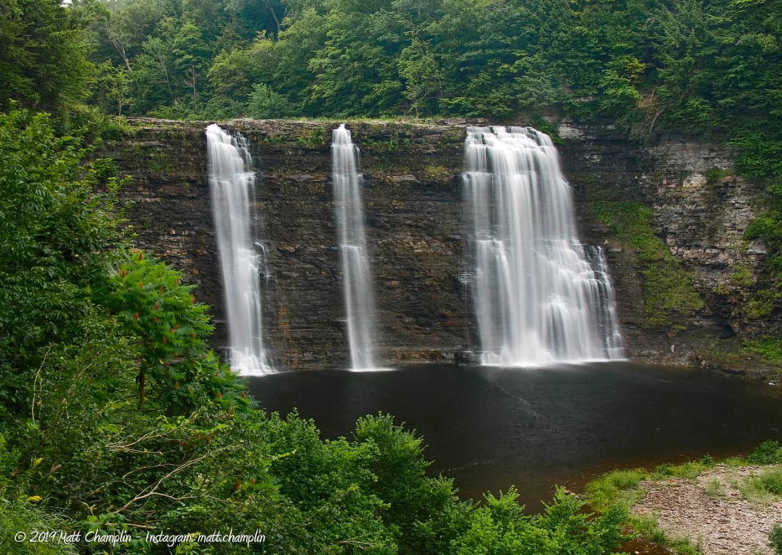
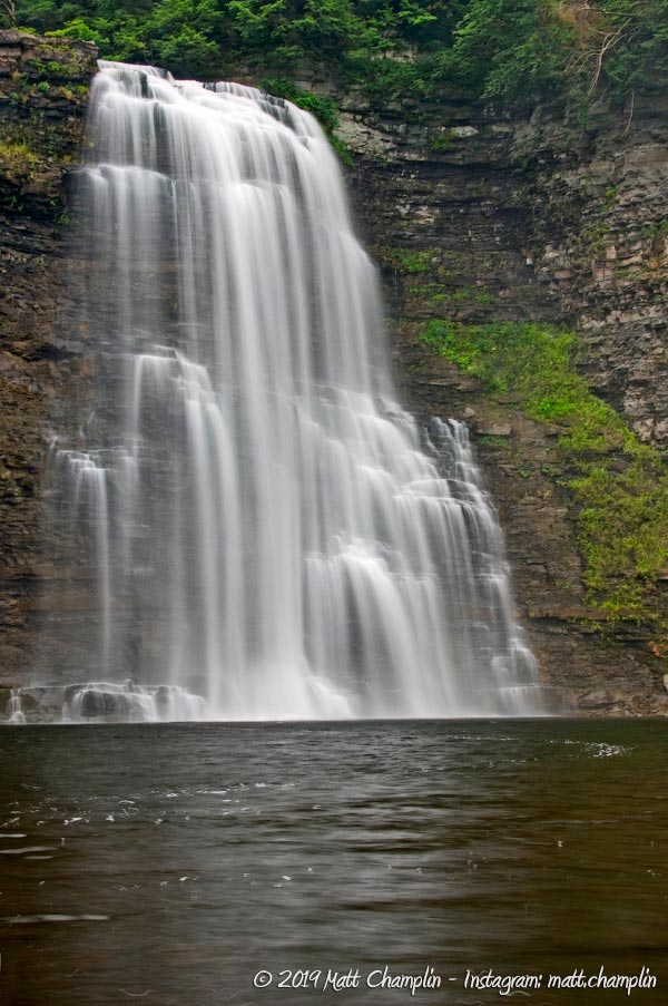
Salmon River Falls is a spectacularly huge waterfall that plunges 110 feet over a steep cliff of shale and limestone as it makes its way westward to Lake Ontario. Unfortunately, before the state enacted rules that required the power companies to have minimal water release from their dams, Salmon River Falls was dry throughout most of the summer. That all changed in 1996 when the state mandated a minimal flow rate over the falls, enhancing its natural beauty year-round. The character of the falls is constantly changing not only with the seasons but also with the activity at the power plant (located just a mile upstream). While the creation of the reservoirs above the falls has changed the Salmon River drastically, it is still possible to get visions of its grandeur when you visit the falls during peak water flow (750 cfs and higher).
At the mean water flow, the falls plunges in three distinct ribbons with uniquely beautiful characteristics. The right-most ribbon is the “primary” falls and thus has the highest and most consistent water flow year-round. The ribbons on the left and center are closest to the viewer and may be either dry or a slight trickle during low flow.
While visiting, take the hike upstream to check out the Salmon River Dam and the Salmon River Reservoir.

History
Salmon River Falls was an important place throughout history – although not necessarily for the beauty of such a large volume of water plunging over the cliff. Back when the Iroquois frequented the area, it was an important fishing spot as the falls were the final barrier to the huge runs of Atlantic Salmon that made their way upriver from Lake Ontario. Taking advantage of this, the Native Americans could collect ample amounts of salmon for smoking and drying, giving them stock for the rest of the season and beyond.
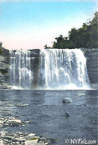
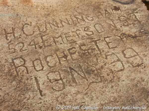
As the area became developed in the 1800s and roads began to crisscross the area, the falls in its natural state became a destination for sightseers even after the fishery had died out due to the numerous mills and dams downstream. Sportfishing above the falls for brook trout rose in popularity in the 1860’s and by the 1890’s, picnicking along the creek bed above the falls was extremely popular. To this day, you can still find carvings in the rock faces dated all the way back to 1892.
By the 1900’s, development of the area was driven principally by hydroelectric power creation. A dam above the falls was finished in 1912 and most of the water was diverted around the falls, reducing it to nothing more than a trickle, sometimes running completely dry (averaging 3-5 cfs). Public use of the area declined during this time and the area became known for drinking, vandalism, and people falling to their death over the cliff. The area was eventually closed to the public completely.
In 1993 the state mandated that the power company sell its holdings that were not used in hydroelectric power creation – thus the DEC obtained the area. Many public hearings were held (and will be continued in the future) to take input from the public about the land and its potential. In 1996, the state mandated that there must be a minimal flow to make the falls have characteristics of a “waterfall” and the area has been slowly gaining popularity with visitors once more.
Hiking / Walking Trails
The Falls Trail (Overlook)
Difficulty: Easy.
Markings: Information kiosk by the parking area.
Distance: About 1100 ft to the gorge.
Description: The Falls Trail is a very easy gravel trail that leads only 1100 ft from the parking area to the final overlook of Salmon River Falls. There are two overlook platforms from the top of the gorge that supply excellent vantage points to view the falls from above. Glance through the trees when you can, to get other viewpoints.
The Gorge Trail
NOTE: The Gorge trail is closed until further notice.
Difficulty: Moderate.
Markings: None.
Distance: About 100 ft from the overlook to the base of the falls.
Description: The Gorge Trail is a short but steep hike down to the river bed. It drops 100 ft in elevation and has a length of 600 ft. The gorge trail is accessible about halfway along the Falls Trail along the right-hand side. Use extreme caution as there are very rough, steep stairways and drops along the way. If you want to view the falls from head on – then this is the trail to do. It’s best to make sure you have enough daylight for the climb back up.
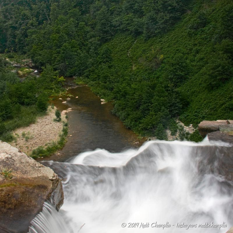
The Riverbed Trail (Above the falls)
Difficulty: Easy
Markings: None.
Distance: About 66 ft from the overlook to the base of the falls.
Description: Not much of a trail as it is only 66 feet in length, this pathway is found at the end of the Falls Trail and gives you excellent access to the riverbed at the crest of Salmon River Falls. From the overlook, continue upstream past the falls until you see an offshoot of the trail that heads down into the riverbed.
Upper Falls Trail
Difficulty: Moderate.
Markings: None.
Distance: About 1 mile from the parking area.
Description: The longest of the trails, this travels 1 mile one way to the base of the dam at the Salmon River hydroelectric power plant upstream from the falls. It travels nicely through woods and small pockets of marshy areas. At the end you can enjoy the sounds of water gushing over the dam, or climb up the side to see (or fish at) the reservoir.
Maps: Unique Area map; Interactive.
Salmon River Falls Interactive Map
Salmon River Falls Media


Interesting Stuff
Rock engravings
Take some time to walk the creek bed below the falls and look at all the old and modern engravings and paintings in the rock. Somewhere you can find an entire Boy Scout Troop engraving from 1920.
Fishing!
Fishing above the falls is an all-year activity; fishing for migratory Pacific Salmon and Steelhead in the river from Almar to Pulaski in the fall and winter. The Salmon River through those towns is full of public access and full of fish. This web page lists access points and maps to the river.
White Water
Rapids along the river are a moderate class III in July-August, which makes for a great adventure to cool off in mid-summer. Check out Adventure Calls Outfitters for more information or to book a trip.
Photography Tips
Photographing the Falls
- The first place you can photograph the waterfalls is from the overlook trails above. There are many opportunities to catch one or all of the falls through the lush forests lining the cliff tops. The final overlooks give you an opportunity to actually shoot the falls looking down at them as they plunge 110 ft into the gorge below.
- Taking the gorge trail down to the creek bed gives you the best opportunity to get unfettered views of the falls. There is a nice overlook halfway down the trail that gives an excellent vantage point and you can get the surrounding cliff faces in one shot. At the bottom, try experimenting with catching the left most water flow and the bend in the shale face that it takes to the left. It’s quite spectacular. Often, you can get shots when people are at the top of the falls to get a sense of size. You are going to want to shoot during overcast days especially.
- The area that the water covers is quite large and in the open so sometimes it’s hard to get everything in one shot. A lot of light enters the area, so shoot on rainy or overcast days to get good exposure values. Try shooting the streams of water individually as they all have their charms and photographic delights.
Proper creek-walk footwear
- Wear the proper footwear for creek walking and climbing. Not only can a quality pair of water shoes prevent blisters and infection, they will help you stick better to the ground and reduce your risk of falling, hurting yourself, or your camera gear.
Silky Water Effect
- To get that smooth cotton-candy look to the falls, you need to use a Neutral Density (ND) filter on your lens. The ND filter will block some of the light from entering the lens without altering the color, and thus allow your shutter to stay open longer. This blurs the water and creates a soft white gloss to the foamy areas of the falls. Check out the article for the all the details.
More tips
- See the Articles for more photography tips.
Who to Contact
NYS DEC
State Land Management
7291 Coon Rd.
Bath, NY 14810
Phone: (607) 776-2165
[email protected]
Whitewater / Kayaking:
Adventure Calls Outfitters
2524 New York 13
Altmar, NY 13302
(888) 270-2410
[email protected]
