High Falls (Columbia County)


Location: Within the High Falls Conservation Area; village of Philmont; Town of Claverack; Columbia County; New York.
Maps: Google Map; Topographic; Trail map (PDF); Interactive map.
GPS: Somewhere in the middle of High Falls: (N 42.24598 / W 73.64998)
Approximate location of scenic overlook: (N 42.24531 / W 73.65095)
Parking lot and trailhead: (N 42.24707 / W 73.65757)
Directions: From Hudson, head east on Columbia St to NY-66/Union Turnpike.
Follow NY-66/Union Turnpike for 1.5 miles and make a right onto Fish and Game Rd/CR-18.
Follow Fish and Game Rd/CR-18 for just under 4 miles until it ends at NY-217 and make a left.
NY-217 will head northeast to Mellenville and then hook south at Philmont.
At about 1.4 miles, turn right onto Roxbury Rd, cross over the creek, and look for the entrance to the parking area shortly on your left.
Use Google Maps.
Parking: A gravel lot off of Roxbury Rd in the village of Philmont has room for more than 20 cars. The trailhead starts there.
Weather
Information / Accessibility / Accommodations
Number of falls: High Falls is considered one waterfall. It’s actually 2. A natural cascade and a man-made mill dam seen above and back from the falls. Within the preserve is another waterfall, although it tends to be somewhat seasonal.
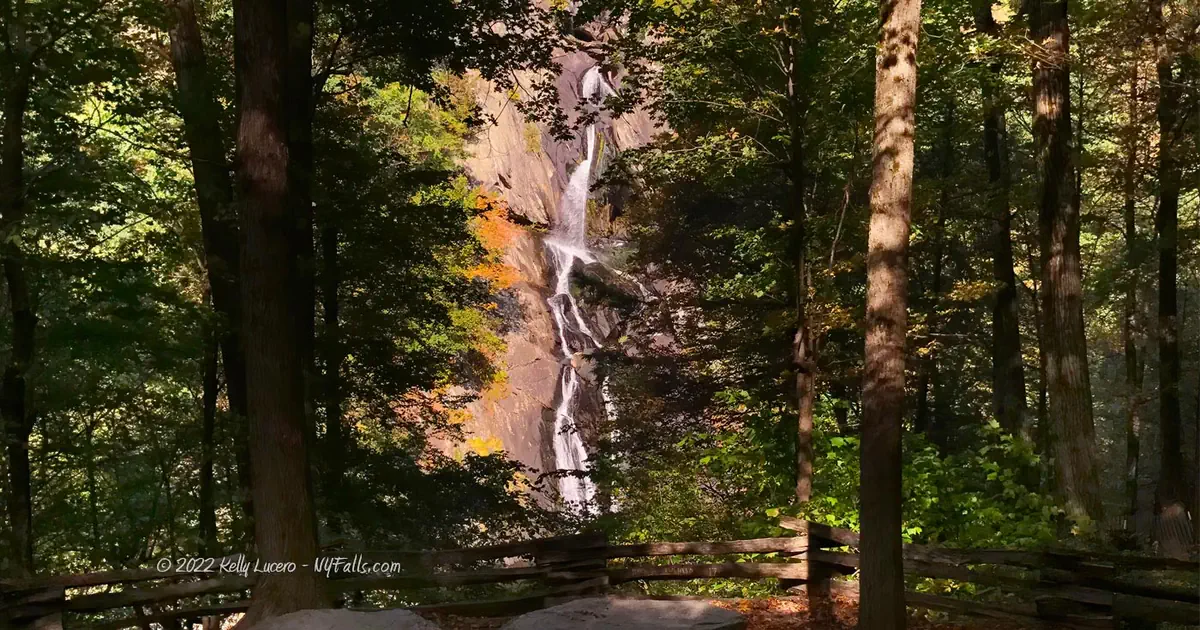
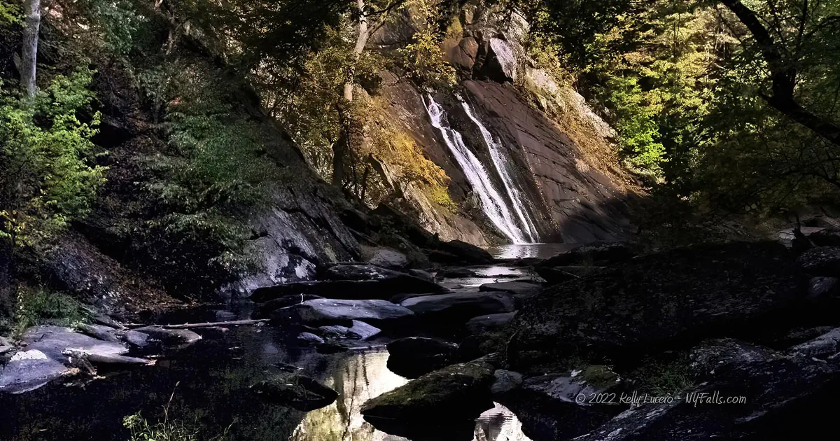
Size/Types: Accounts of the height of the falls vary. An 1873 map has it listed as 150 ft high, while more modern accounts have it as 70-100 ft. So how tall is it exactly? We aren’t sure. Our best guess is that the lower, natural falls is at least 70 ft tall. Just above the falls, and visible from the viewing area, is a 10-20 ft tall man-made dam. While it’s set back quite a distance from the top of the natural falls, from the viewing area it looks like it’s the first tier.
Starting with the even cascade of the old dam, the water travels a few hundred feet to the natural falls, then tumbles and zig-zags down a narrow notch it has carved into the hillside. In low flow it can create multiple long ribbons of white water. In higher flow, it fills the fissure completely. It’s a narrow, steep and visually striking waterfall.
The seasonal cascade that can be found on the blue trail is likely 40 ft tall or more. On an unnamed tributary coming from the north, it’s a narrow ribbon cascade along a wooded hillside that spreads out dramatically in its last 10 ft descent into Agawamuck Creek. The folks over at HiketheHudsonValley.com have dubbed this one as “Axle Falls” because of an old rusted vehicle axle that was once stuck at its base. While the axle is no longer there, we think it’s an awesome name.
Best time to visit: Year-round.
Flow: Moderate. Avoid visiting in dry spells.
Waterway: Agawamuck Creek which starts in the northeast in Spencertown. A retaining dam at the top of this hill at Summit St creates Summit Lake, which then spills into this gorge. The creek then hits another dam, which is the first drop visible from the lookout here. A few miles west, at Mellenville, Agawamuck merges with Claverack Creek. From here it continues south west through the town of Claverack and takes an abrupt turn north just after the village. It continues north to Stottville and merges into Stockport Creek at Stockport. Stockport Creek continues a few miles west and empties into the Hudson River. The Hudson flows south to New York City and empties into the Atlantic Ocean.
The smaller cascade that can be found on the blue trail does not appear to be a natural waterway. It’s likely the remnants of the mill race that was constructed just uphill and powered the mill complex at the falls.
Time: About 45 minutes.
Seasons/Hours: Daylight hours.
Admission: Free.
Handicap Accessibility: It’s a dirt trail with a few short and steep gradients. It’s not suitable for chairs and while the average gradient it under 10% it may have some short challenging areas for some.
Pets: Allowed, but keep them on a leash and clean up after them.
Accommodations: Trails. No restrooms are on site. There are a few restaurants and shops a short drive north on Main St in Philmont.

Description
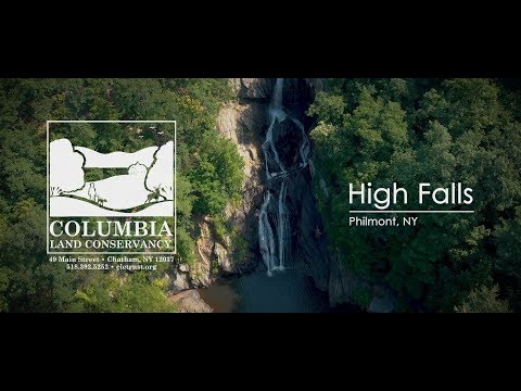
High Falls was not accessible to the public until the 1990s. A spectacular ribbon cascade exceeding 70 ft tall, topped by a mill dam from the mid-1800s is what established Philmont, NY as Factory Hill and made it a center for woolen goods manufacturing into the 1900s.
The High Falls Conservation Area is a 47-acre wooded property with Agawanuck Creek and High Falls as its centerpiece. A small network of trails (totaling about 5 miles) gets you sights of the water at many points, including the perfect view of the falls from a break in the trees. Want to get in and out? The hike right to the falls is a pretty casual one and you can do it in about 45 minutes, and the view is worth it.
While there, check out Summit Dam, which is just above the falls and a short drive east. Before visiting, read up on the history of Factory Hill and see if you can spot all the former mills and factories in the village.
History
Agawamuch Creek (sometimes spelled Ockawamick), a tributary of Claverack Creek is actually the native name for the more anglicized “Claverack” Creek.
Dutch settlers started arriving in the area in the mid 17th century, but records are lacking. The first mill, a gristmill was built at the base of the falls by a “Mr. Gifford,” at an unknown date and a settlement rose up surrounding it. In its early days a satinet and carpet factory (owned by James Philip & Co) was built upstream from the mill, and its fledgling industrial hamlet became known as “Factory Hill.”
George Philip, the namesake of the village, built a large dam in the gorge above the falls in 1845. This is the dam that can be seen from the falls overlook on the green trail. From the reservoir at the dam, he cut a mill race and constructed a pond north of the falls. This mill race is in ruin today and is what eventually created Axle Falls. The water rights along the race were leased by several mills over the years. Philip then built a dam upstream to create a 36-acre reservoir, the one east of Summit St., to keep flow consistent in all seasons. His satinet factory was built in 1847 between the pond and the mill dam. In 1855 he built a small paper mill along this race, which manufactured straw wrapping paper. It burned down in 1859. Samuel Rogers built a paper mill on the site of the original Gifford gristmill in 1858. Known as the Agawamuck Paper Mill, under ownership of his son H. W. Rogers it continued the tradition of producing straw wrapping paper, and eventually expanded to a larger complex downstream where the Upper Blue Trail leads to.
Philip’s satinet factory, which produced fine woolen goods was not successful, and it was later converted to produce what was…
Underwear was big business in Philmont, apparently. In 1862, Nelson P. Aken built an underwear factory downstream near where the Upper Blue Trail is now. It was expanded in 1865. Philip’s satinet factory burned down in 1876 and was replaced by a larger brick factory and started manufacturing underwear under the ownership of William A. Harder. In 1886, Midland Mill was established by John Hayes and manufactured underwear. I could not find a location for this operation. The Victory Lingerie Company was established in 1919. Aside from underwear factories, several woolen plants and clothing factories came and went in the village. Consistent water power at Factory Hill was so crucial to the settlement, that another dam was constructed upstream to the west and higher in the Taconic Mountains to create Philmont Reservoir (56 acres) and to ensure consistent supply throughout the year.
The village was incorporated on July 2, 1892.
After WWII mills began closing as they competed with larger factories and synthetic fibers. Today, none of the mills or factories that once gave this village its industrial reputation are operating. Population has been slowly declining ever since.
The Summit Mill, the rebuilt Philip hosiery mill, still stands today on the northern slopes above the falls and mill dam. It’s been rehabilitated for commercial purposes. Some older mill and factory buildings along Main St and Canal street still stand today, many vacant.
The land that is now the Conservation Area was privately owned until the 1990s when it was donated to the Columbia Land Conservancy (CLC) by the Meltz and Schnackenberg families.


Hiking / Walking Trails
Difficulty: Easy, with a quick descent at the start and then a slight gradient up the rest of the way.
Markings: The dirt/gravel trail is clearly defined. Wooden signs say “to falls” and “overlook.”
Distance: 0.6 miles one way if you take the most direct route. The red trail leads to the same view of the falls but is about twice as long.
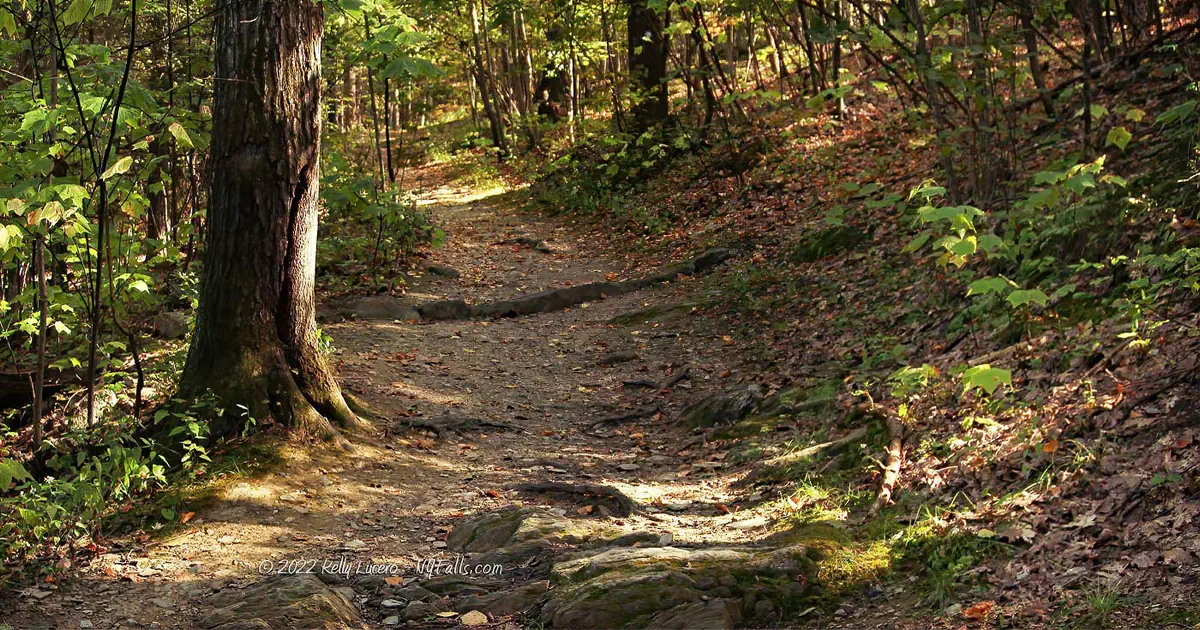
Description: From the parking area, proceed past the wooden gate and towards the information kiosk.
Sign in if you’d like and then proceed on the Green trail.
After a quick descent, you will come across a wooden footbridge that crosses a small tributary.
Shortly after the bridge, you come across a junction with the Blue trail. Ignore it and keep going.
Red Trail Detour (optional)
After about 1/5 of a mile you will reach a junction with the Red trail. The red trail will loop further south into the woods and then back to the Green trail just before the falls overlook. It’s almost twice the distance. It’s up to you if you want to take this longer route. If you do take the Red trail detour, when it merges back with the Green trail, make a right to get to the overlook.
Green trail (continued)
From that first junction with the Red trail, continue along the green trail for another 1/3 of a mile and you will come across the Blue trail on your left. This is actually a different trail than the first blue trail you passed on the beginning. You can get to “Axle Falls” through this trail, or continue on the Green trail to see High Falls.
Blue trail/Axle Falls Detour (optional)
Follow the blue trail down the the creek (about 0.1 mile) and then head right along the creek (about 0.2 miles). Look across the creek to spot the Axle Falls. Backtrack to get back to the Green trail, and once you do, make a left to continue to the overlook.
Green trail (final stretch)
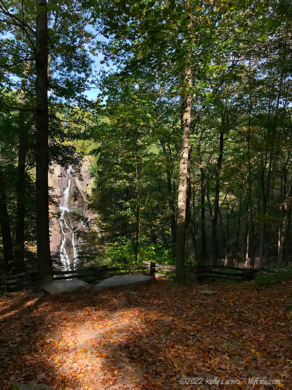
From that first junction with the Blue trail, continue along the Green trail for one last tenth of a mile to the overlook area where you should see the falls through the trees. There’s a picnic table and wooden fence.
Off-trail to the bottom
Official trails stop at the overlook area, but it’s clear that many people continue on to the creek at base of the falls. So much that it looks like the green trail continues east. If you choose to go further, it’s at your own risk. There are some large boulders you will have to scale to get fully down, and it’s potentially dangerous.
Getting back
Head back west along the Green trail to the parking area. If you didn’t take the Red trail detours before, now’s your chance.
Map: Trail map (PDF); Interactive.

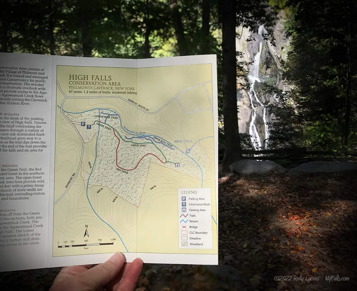
High Falls Conservation Area Interactive Map
High Falls (Columbia County) Media
High Falls Videos

Who to Contact
Columbia Land Conservancy
[email protected]
clctrust.org