Niagara Falls FAQ: The Niagara River
- How tall is Niagara Falls?
- Are Niagara Falls the tallest in the world?
- What shape are the Falls?
- Where does all the water come from?
- How fast does water fall down Niagara Falls?
- Why is the water that shade of blue/green?
- What is that foam below the falls?
- Why do they call it Luna Island?
- What are the rock layers that make up Niagara Falls?
- How loud is Niagara Falls?
- Where did the name ‘Niagara’ come from?
- How old is Niagara Falls?
- Have the Falls ever stopped flowing?
- Has Niagara Falls the Falls ever frozen over?
- Has a boat ever gone over the falls?
- How many people have gone over the falls?
- Why isn’t the “Cave of the Winds” an actual cave?
- How far have the falls moved over time?
- How did they build the first bridge over the Niagara Gorge?
- How much of the water is being diverted for power generation?
- When and where was electricity first generated at Niagara Falls?
- Was electricity discovered at Niagara Falls?
- How many power plants are there at Niagara Falls?
- Which power station is the biggest?
- How do the power plants turn water into electricity?
- How much power is generated by Niagara Falls?
- How has power generation changed the Falls?
- What are those structures upstream from the falls?
- What does the International Control Dam do?
- How many people visit the Falls each year?
- When do they light up the falls?
- Can I request colors for Niagara Falls lights?
- When are the fireworks?
- What Casinos are near Niagara Falls?
- What tours of Niagara Falls are available?
- Where can one play Golf at Niagara Falls?
- Where is the best view of Niagara Falls?
- What is the closest viewing area at Niagara Falls?
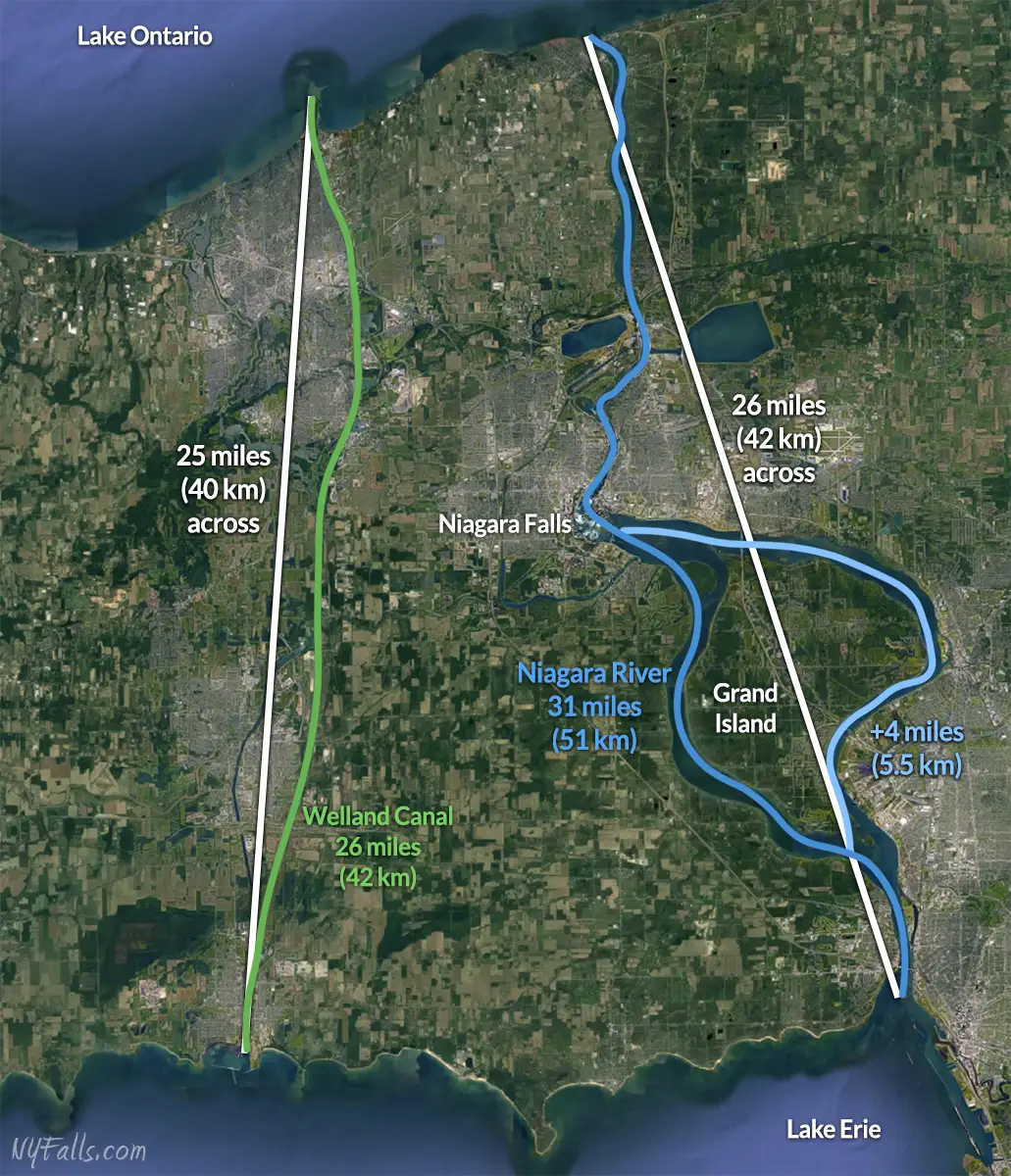
- How long is the Niagara River?
- What is the elevation difference between Lakes Erie & Ontario?
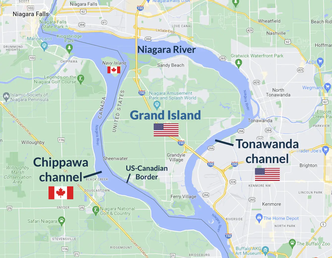
- When the Niagara River splits around Grand Island, does it become two rivers?
- Where is the Niagara River deepest?
- How did the Niagara Whirlpool form?
- In what direction does the Niagara Whirlpool flow?
- How deep is the water at the Niagara Whirlpool?
- What classes of rapids are in the Niagara River?
- What is Devil’s Hole?
- Where are the Niagara River Gorge walls the tallest?


Niagara Falls Visitors Guide
This Comprehensive Niagara Falls Historic Timeline is a part of our Niagara Falls Guide, a comprehensive look at The Falls, top attractions, and other awesome parks in the region, with a focus on photography and nature.
How long is the Niagara River?
As the crow flies, the Niagara River stretches just over 26 miles (42 km) from Lake Erie to Lake Ontario. It is easy to just measure a straight line across like that, but the Niagara River winds back and forth and has multiple paths. If you were to sail from the inlet on Erie to the outlet on Ontario (and yes, over the falls and past the Niagara Whirlpool Rapids) it would be about 31 miles (51 km), that is if you chose to sail down the west side of Grand Island. Heading down the eastern side would bring your journey to a distance of 35 miles (56.5 km).
Of course you can’t sail over the falls, so the Welland Canal was completed in 1854 to make the journey between the two lakes possible. The canal, just west of the Niagara River, is just under 26 miles (42 km) long; or 25 miles (40 km) across; as the crow flies.
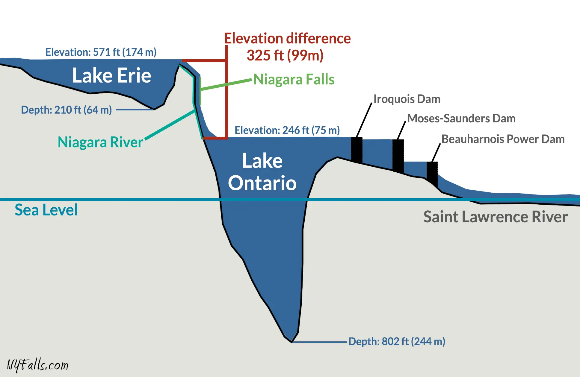
What is the elevation difference between Lakes Erie & Ontario?
Lake Erie is 571 ft (174 m) above sea level. Lake Ontario is 246 ft (75 m) above sea level. The Niagara River drops 325 ft as it goes from Erie to Ontario, with roughly 194 ft (59 m) of that happening at Niagara Falls.
Right: The elevations of Lakes Erie and Ontario (cross-section). Note the steep elevation change at Niagara Falls. Depths and distances are not drawn perfectly to scale.
When the Niagara River splits around Grand Island, does it become two rivers?
The Niagara River splits in half as it passes around the massive Grand Island. Both sections are still parts of the Niagara River, but the western run is called the “Chippawa” or “Canadian” channel while the eastern run is referred to as the “American” or “Tonawanda” channel. The Chippawa channel is the more direct route and carries nearly 60% of the river’s flow past Grand Island. The US/Canadian border actually runs through the Chippawa channel with more than 2/3 of the channel and Navy Island falling within Canadian territory. All of Grand Island falls within US territory.
Where is the Niagara River deepest?
The deepest spot in the Niagara River is just below the Horseshoe Falls.
Here the water is roughly 170 ft (52 m) deep. The erosion from the tumbling water has gouged into the river bed, creating a depression almost as deep as the falls are tall. Under the American Falls, piles of rock debris keep the immediate area shallow.
How did the Niagara Whirlpool form?
The Niagara Whirlpool formed nearly 4,200 years ago when the erosion and recession of Niagara Falls, which up to this point was a sluggish process, reached a soft spot in the landscape. Saint David’s Buried Gorge was an ancient, pre-glacial river valley filled in with soft glacial silt and stone. When Niagara Falls eroded its way into this hidden gorge, it rapidly began washing away the gorge’s soft filling. It is speculated that when the Falls hit the buried gorge, it was just a matter of weeks, perhaps even days of violent erosion while it carved out the Whirlpool basin. It was a swift and powerful geological event considering the Falls had taken nearly 8000 years to get to this point.
Saint David’s Buried Gorge ran perpendicular to the current path of the Fall’s erosion, and resulted in a 90 degree turn in the river. Just upstream the narrow Niagara Gorge at the Whirlpool rapids sends water jetting into the Whirlpool basin. It hits the solid rock basin across the Whirlpool at Niagara Glen. Thousand of years of these forces has resulted in a dimpling of the basin; giving it an oval shape that juts past the turn in the river.
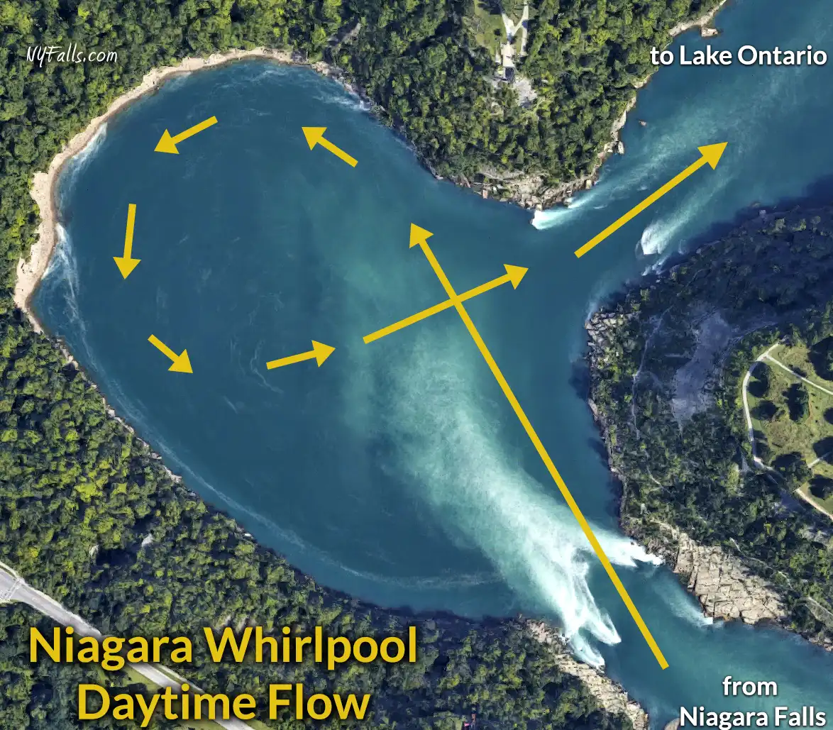
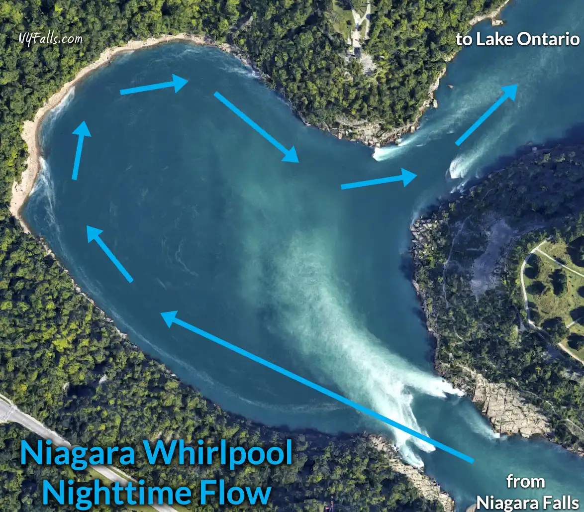
In what direction does the Niagara Whirlpool flow?
It depends on the time of day.
When the Niagara River is at full flow the Whirlpool will flow in a counterclockwise direction. When the river flow drops, usually when more flow is diverted to the power plants, the flow of the whirlpool reverses (clockwise). This usually happens during the tourist off-season (November 1 through April 1).
Just upstream from the Whirlpool is the narrowest section of the Niagara: the Eddy Basin. This pinch in the gorge is not sufficient for the normal flow of the river to pass through, so some of the water is pushed backward. The water at the shore actually flows backward at this location.
How deep is the water at the Niagara Whirlpool?
The Niagara River reaches depths of 125 ft (38 m) as it passes through the Niagara Whirlpool.
For more information on the Niagara Whirlpool, visit our Niagara Whirlpool State Park page.
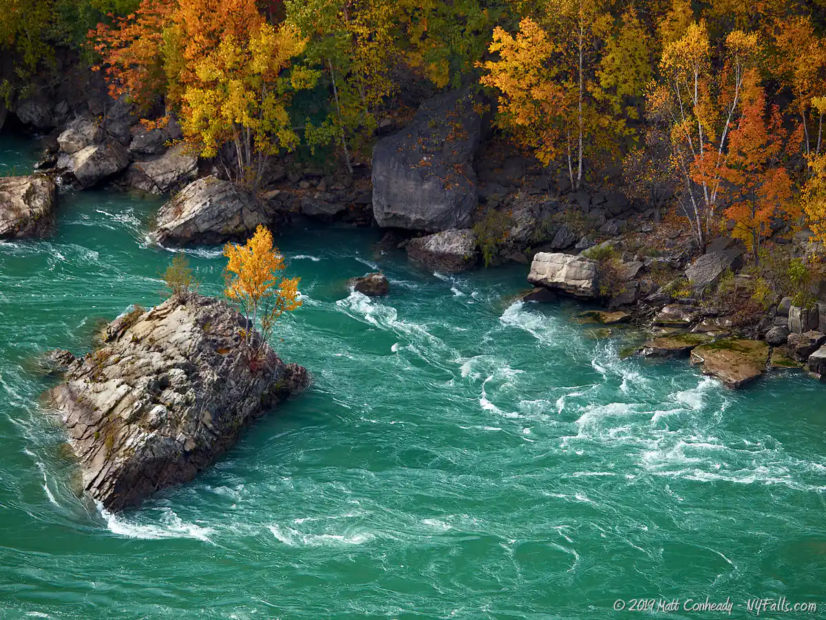
What classes of rapids are in the Niagara River?
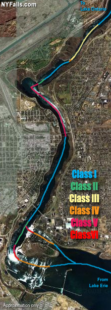 Specific sections of the Niagara River are classified differently. First let’s review what the classes stand for. Whitewater rapids are graded on the International Scale of River Difficulty, which has 6 “Classes.”
Class I: Easy. Waves small; passages clear; no serious obstacles.
Class II: Medium. Rapids of moderate difficulty with passages clear. Requires experience plus suitable outfit and boat.
Class III: Difficult. Waves numerous, high, irregular; rocks; eddies; rapids with narrow passages, requiring expertise in maneuvering; scouting usually needed. Requires good operator and boat.
Class IV: Very difficult. Long rapids; waves high, irregular; dangerous rocks; boiling eddies; best passages difficult to scout; scouting mandatory first time; powerful and precise maneuvering required. Demands expert boatman and excellent boat and good quality equipment.
Class V: Extremely Difficult. Exceedingly difficult, long and violent rapids, following each other almost without interruption; riverbed extremely obstructed; big drops; violent current; very steep gradient; close study essential but often difficult. Requires best person, boat, and outfit suited to the situation. All possible precautions must be taken.
Class VI: Unrunnable. Chances are: you’re going to die on this.
Most of the Niagara River’s waters are graded as Class I.This includes the run from Lake Erie up to the Cascade Rapids just above the falls. Here the water’s classification is up for debate. Although the whitewater is runnable (probably a Class IV), that would mean ending up over the falls at the end. The Falls themselves and the immediate area below are certainly a Class VI: unrunnable.
The navigable portions of the Upper Great Gorge (below the Falls, where the Maid of the Mist boats run) are roughly a Class IV. Although the water here lacks free-standing waves and obvious obstacles, the whirlpool currents can trap small craft and push them towards the rocky cliff or into the downpour of the falls. In addition, high quantities of bubbles rising from below can cause buoyancy problems for personal craft.
Heading downriver from the basin of the Falls, the gorge remains wide and the water calms, eventually decreasing to a Class I. At the Whirlpool Rapids Bridge the gorge suddenly narrows by more than half and water speeds up to approximately 22 mph (35 kmph) forming the world famous Whirlpool Rapids. Here the large volume of the Niagara is forced through a basin unable to fully support its bulk, forming violent currents and standing waves reaching 15 ft high. The rapids shoot out of the narrow gorge and into the swirling Niagara Whirlpool. Here craft would need to fight the powerful current to navigate the 90 degree bend in the river, in order to escape the rapids. The Whirlpool Rapids run is easily a Class V and at times of higher flow, un-runnable.
Just past the Whirlpool, the gorge widens and the river slows for a short bit, until it reaches Devil’s Hole at the Lower Great Gorge. Again, a constriction of the gorge basin speeds up and agitates the Niagara; forming the Lower Whirlpool Rapids. Not nearly as violent as upriver, the water here reaches a Class III.
After Devils Hole, the river calms and it is smooth sailing all the way north to Lake Ontario.
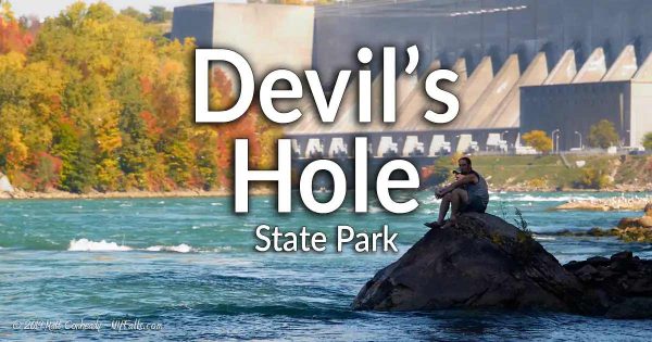
What is Devil’s Hole?
The Devil’s Hole is the name given to a small ravine cut into the American side of the Niagara Gorge by an ancient post-glacial tributary, Bloody Run. The tributary is now virtually developed away, but 12,000 or so years ago is was a much larger torrent into the Niagara Glen. During the events outlined below it was a seasonal creek.
The Hole and stream got their modern names from the Devil’s Hole Massacre that occurred here on September 14, 1763, during the French and Indian War. A force of 300 to 500 Seneca warriors ambushed a British supply (led by Porter Master John Stedman) convoy and drove them, their wagon, supplies and horses off the cliff here. 102 members of the convoy died, including several civilians. Only a few people escaped, including one drummer boy and John Stedman. When reinforcements arrived they found only 80 bodies in the ravine, and the creek was flowing red with blood.
There is a limestone cave at Devil’s Hole, which is commonly thought to be the “Devil’s Hole” itself. It’s not. Devil’s Hole is the ravine, the State Park is the 42 acres surrounding it, and the cave is often referred to as the Cave of Evil Spirits.
See our page on Devil’s Hole State Park for more information.
Where are the Niagara River Gorge walls the tallest?
The Niagara River Gorge’s massive cliffs reach maximum height at the escarpment itself near Queenston, ON. Here the Gorge walls are nearly 322 ft (98 m) high. The height of the cliffs decline as you move further south, eventually reaching their lowest height at Niagara Falls.
Niagara Falls Visitors Guide
Filled with facts and figures, tips, photos, and profiles of parks and main attractions, our guide to Niagara Falls shows you all the amazing stuff the region has to offer, while leaving out the gaudy tourist taps.
