Wiscoy Falls


Location: Within the Town of Hume; Allegany County; South of Letchworth State Park; New York.
Maps: Google Map; Topographic; Interactive map.
GPS Coordinates: Wiscoy Rd Bridge: N 42.50451 / W 78.08215
Wiscoy Creek Dam: N 42.50530 / W 78.08806
Directions: Wiscoy is a former village just south of Letchworth and Portageville. The journey will take about an hour from Rochester. From Rochester or the NYS Thruway: Head south on I-390 to exit 7 and take NY-408 west towards Mt Morris/Letchworth State Park. The directions get a little complex from there, so it’s best to leave it up to Google Maps.
Parking: Note only roadside views of the falls is possible at this time.

Weather
Information / Accessibility / Accommodations
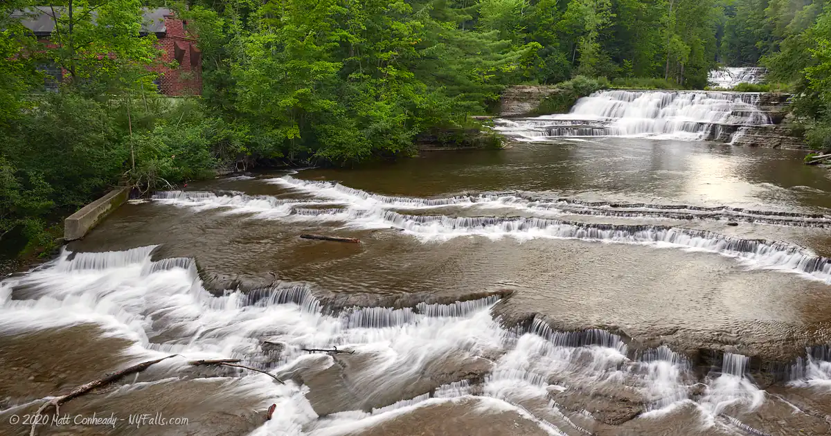
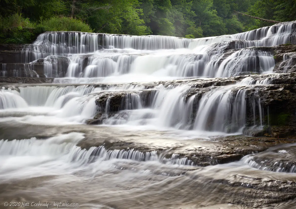
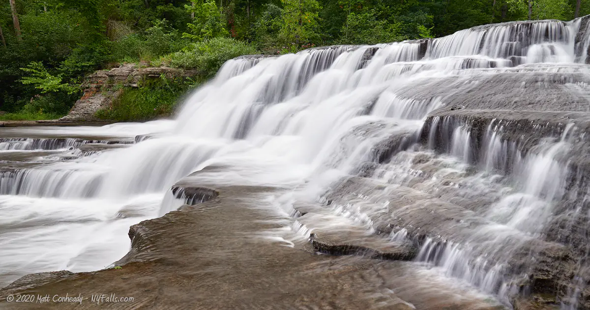
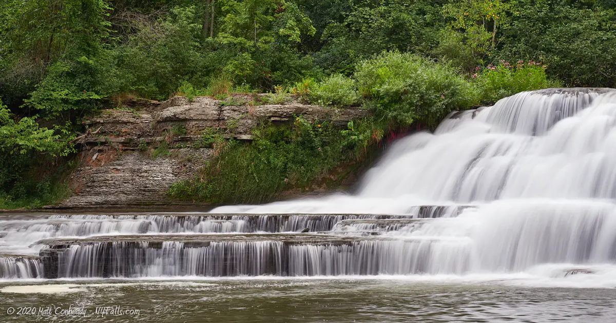
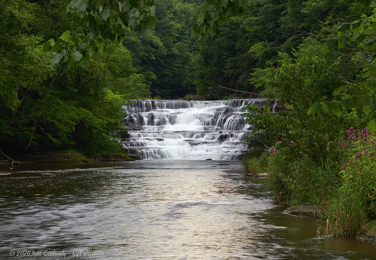
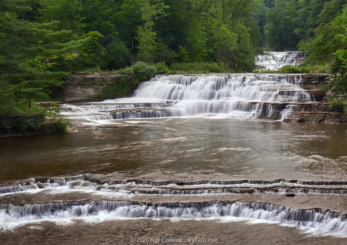
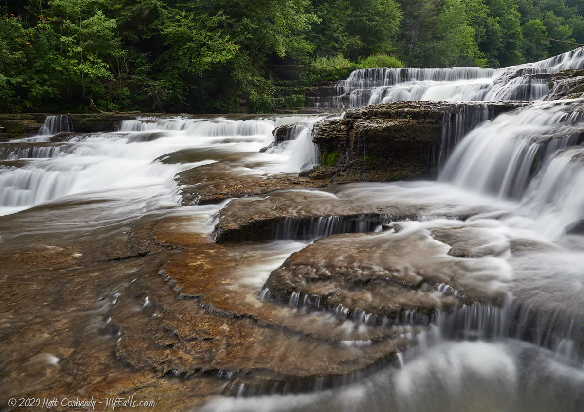
Number of falls: As visible from the road, the primary falls is made up of 3 sections of drops. I’ve seen several books and websites classify this as 5 waterfalls. There’s a sizable crescent dam upstream.
Size/Types: From the east (road) going upstream there are two ledges a foot or two high each. The middle cascade is roughly 15 ft high. Visible beyond that is the upper falls which is about 25 ft high. Not visible from the road is one more natural cascade, which is maybe 10 ft in height, and the crescent dam, 33 ft high, which often has two steep and powerful streams of water pouring from it.
Best time to visit: Year-round.
Flow: Reasonable flow throughout the year. The currents can get pretty dangerous in high flow. View the page on safety.
Waterway: Wiscoy Creek. The creek starts out as a pond about 20 miles west of here in the town of Eagle, Livingston County. Just a couple of miles east of the falls, it joins the Genesee River, which heads north through Letchworth State Park, the city of Rochester, and then empties into Lake Ontario.
Time: A few minutes to an hour.
Seasons/Hours: Daylight hours.
Admission: Free.
Handicap Accessibility: While there is no sidewalk, there is room on the shoulder of Wiscoy Rd bridge to view the falls. The parking lot is a little rough. The trails are definitely not accessible.
Pets: No rules are posted, but pets need to be on a leash in public.
Accommodations: There are some trails. They are not maintained. There are no restrooms and I couldn’t find a bite to eat anywhere near this place.
Description
The Town of Hume in Allegany County has a rich history of early American industry, powered by its several reliable streams that travel from the western hills into the Genesee River Valley. Wiscoy Creek was no exception, having a thriving settlement centered around a score of mills that cradled the 5 waterfalls along this short stretch. With the last trace of the sole remaining mill removed in 2014, Wiscoy Falls feels very natural. While the creek isn’t as large as the nearby Genesee River, the falls fans out as it approaches Wiscoy Road, making it seem massive in scale. The view from the road’s bridge offers one of the most picturesque waterfall scenes in the state – almost as if composed carefully by an artist. The smaller cascades in the foreground are wide and jagged. The creek constricts further upstream, revealing two more cascades up and off into the distance. Peeking out from the trees next to the falls, is a quaint red brick RG&E substation that only adds to the scene’s allure.
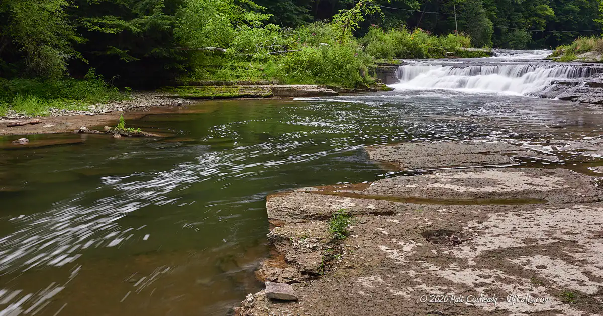
A trail (Now closed) leads from the parking area upstream and past the first set of falls and to a series of small but interesting cascades not visible from the roadside. A deep pool under the last cascade is a popular swimming hole on hot summer days. After this, the creek levels off and leads to a massive hydroelectric dam, which itself creates two large cascades down its steep face. It’s quite a short hike to get to the dam and back, although a bit of climbing of the falls is often required. While Letchworth, with its larger 3 waterfalls (as well as several others scattered throughout the park) is a short drive away, Wiscoy Creek offers a wildly different and up-close perspective on a unique arrangement of cascades. The water flows well year-round and is considerably clean. Although traffic has picked up in recent years, it is simply lesser known, and in the middle of nowhere, so it does offer some peace in comparison.
The falls and the trail do not seem to have any signs of stewardship. In all honestly the town should develop this into a park, not only for better enjoyment for the locals, but to bring in a little tourism. Wiscoy Falls can carry the cover of a brochure and most definitely deserves to be more well known. Unfortunately, the neighboring hamlet is barren of any attractions and eateries, meaning the most people can do is stop and enjoy the water for a moment before moving on to better things.
History
The name “Wiscoy” comes from the Caneadean language, meaning “The Creek of 5 Falls.”
The Town of Hume, probably named after Scottish philosopher and historian David Hume, was first settled by Roger Mills in 1806. At the time, Hume was a part of the town of Angelica. Mr. Mills settled at the upper falls (Mills Mills Falls at the intersection of Mills Mills Road and Armison Rd west of here) and constructed a log cabin, dam, and saw mill. A gristmill was built the following year. A successful venture, the gristmill served farmers and families within a 40-mile radius, including the native Caneadea Native Americans who originally inhabited the region. The gristmill was also used as a makeshift inn for those traveling through, as well as the new settlement’s post office. This settlement was appropriately named “Mills Mills” and is found about 2.5 miles west of Wiscoy Falls.
Wiscoy itself was formerly named “Mixville” after pioneer settler Ebenezer Mix of Batavia. He built a sawmill on the southern bank of the falls, as well as a bridge spanning the creek in 1828. The following year Henry Torrey constructed a gristmill and inn. In the 1840s a flume was constructed on the north side of the creek, which carried water power to a Cabinet Shop (once located where the parking area is today). Improvements to the existing mills, as well as newly constructed ones allowed the village to grow and local businessmen to envision the growth of “Mixville” – an industrial city powered by the waters of Wiscoy Creek. The Mixville Association was founded to make it happen, but unfortunately, within years a devastating flood and constant land ownership disputes drove the effort into bankruptcy.
In 1903, land upstream from the mills was sold to the Fillmore Electric Company for the purpose of building a dam and power plant to supply the village with power. The dam and power plant have gone through several upgrades over the years and it is now operated by Rochester Gas and Electric.
At some point, Wiscoy seems to have lost its status as a village.
The Cabinet shop that was once adjacent to the falls stood abandoned for a number of years until it was demolished in the fall of 2014.
During my research I found an “Ebenezer Mix” credited for co-authoring a biography of the 1842 book: Mary Jemison: the White Woman of the Genesee. I’m unsure if this is the same Ebenezer that set up mills at Wiscoy. Further research into his life shows that he worked as a mason, educator, and land agent.
Hiking / Walking Trails
Note: The trail here has been closed and is now marked as private property. Do not trespass.
The information below is kept for archival purposes, or in case the trail reopens, but that is unlikely in the near future.
Difficulty: Easy to walk from the parking area to the bridge, which gives you the best view of the falls. There’s a moderate challenge to proceeding along the north trail, and entails some scrambling up the slippery sides of a few falls.
Markings: None.
Distance: Less than 100 feet to the bridge view. A hike up the trail is about 2,000 ft.
Description: While there is a trail on the south end of the creek, I recommend the north end, which you can pick up from the parking area.
- Right from the parking area, you can scramble down to the creek where the first 2 small ledges are.
- Head back up and take the trail that heads uphill and towards the middle section of falls.
- You have to do a little climbing up the right side to get above the middle falls. Use caution.
- The trail continues a few hundred feet to the upper falls. Again, climbing will get you to the top. Be careful as the rocks tend to be slippery here.
- Shortly after reaching the top is the final natural cascade, which has a deep pool below it.
- Another climb and the creek will level off. Just around the bend is the dam. You can walk right up to it.
- Come back the way you came.
Map: Interactive.

Wiscoy Falls Interactive Map
Wiscoy Falls Media
Wiscoy Falls Videos
More coming soon…
Interesting Stuff
Mills Mills Falls
Mills Mills seems redundant, but this former mill site was owned by Hume’s first settler Roger Mills. The falls are surrounded by private property today, making it inaccessible, but you can spot parts of it from the road. Armison Road passes over Wiscoy Creek. To one side is a 10 ft high dam and to the other is a long series of cascades totaling about 20 ft in height. The dam is easily spotted from the bridge. The natural cascades, not so much. There’s no spot to park and the bridge isn’t all that great for pedestrians. Map
Photography Tips
Shoot wide
- This falls is large and spread out. Bring a wide-angle lens and try to fit as much of it as you can in the frame. The bridge is as far back as you can shoot.
- When shooting wide, try to get keep those first 2 small cascades in the foreground and in focus. This will make the viewer feel like they are standing in the creek and close to the falls.
Mornings are best
- The sun will dip behind the falls in late afternoon and evening making exposure difficult. Get there in the morning to have the sun on your side.
Use people for scale
- Photos of Wiscoy Falls are misleading. It’s much larger in real life. The place is pretty popular with visitors and bathers recently. Use this to your advantage and include them in the shot to give a sense of how large these falls are.
Silky Water Effect
- To get that smooth cotton-candy look to the falls, you need to use a Neutral Density (ND) filter on your lens. The ND filter will block some of the light from entering the lens without altering the color, and thus allows your shutter to stay open longer. This blurs the water and creates a soft white gloss to the foamy areas of the falls. Check out the article for all of the details.
More tips
- See the Articles for more photography tips.
Explore More

Letchworth State Park
Referred to as “The Grand Canyon of the East,” Letchworth is nowhere near as large or interesting as the National Park. But for the region, it is a beautiful giant park, with a dozen or so waterfalls, plenty of trails, and some of the best sights in the northeast. Think you’ve seen it all before? You most likely haven’t. Check out this guide to find all of the waterfalls in the park.
Who to Contact
Town of Hume
585-567-2666