Waterport Falls


Location: Hamlet of Waterport; town of Carlton; Orleans County; New York
Maps: Google Map; Topographic; Interactive map.
GPS Coordinates:
- Waterport Falls: N 43.32733 / W 78.23952
- Oak Orchard Dam: N 43.32653 / W 78.23963
- DEC parking lot: N 43.32774 / W 78.23495
- Viewing area: N 43.32761 / W 78.23812
Directions: Take NY-104 to Gaines and head north on NY-279 (Park Ave). After about 3.5 miles you will pass the Waterport Hydro complex on your left. Google maps has this driveway as a fishing access road. That is incorrect. The next driveway north is the one. It has a brown wooden sign with yellow text. It’s a gravel driveway with parking space.
User Google Maps for directions.
Parking: The NYS DEC provides parking for fishing access at this location. The gravel lot off of Park Ave (NY-279) has room for over 30 cars. It’s very possible this can get full when fishing heats up in the fall. Overflow parking is just south of this lot, on the side of the road, next to the hydro plant transformers.
Weather
Information / Accessibility / Accommodations
Number of falls: 1
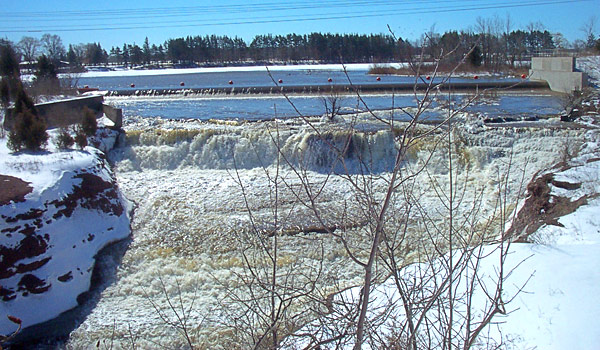
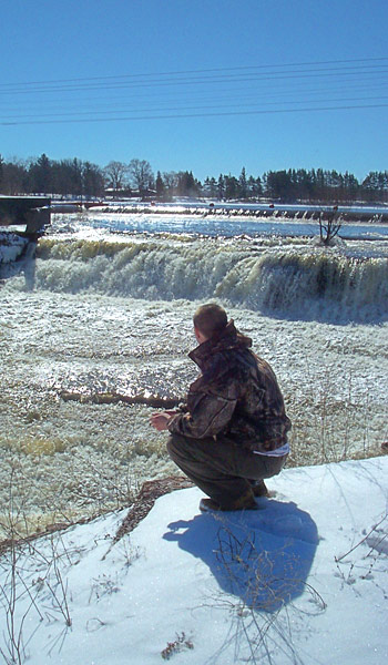
Size/Types: Waterport Falls, while it appears natural, is a man-made waterfall created by overflow coming from the Oak Orchard Dam and Reservoir. It starts out just below the dam, heads north, dropping very gradually over several small ledges, and then turns almost 90 degrees. At that point the drop is pretty steep creating a frothy flow. It cuts a notch through red Medina Sandstone, which gives it a striking appearance in bright sunlight. From the dam, the length is about 250 ft, dropping just shy of 50ft along the way.
Best time to visit: Early spring.
Flow: Low or not at all. After periods of large snowmelt or heavy rain, dams in the area may be releasing large quantities of water. This is a good time to go. It tends to be completely dry in summer. Fall is okay if there is regular rain that week.
Waterway: Oak Orchard Creek which gets its start near the Oak Orchard Marsh near Alabama, NY in Orleans and Genesee Counties. The Marsh is a National Natural Landmark and includes the Oak Orchard WMA and the Iroquois National Wildlife Refuge. It flows over 8 miles north to Medina, where it flows under the Erie Canal at Medina Falls. Just north of Medina the creek is dammed to create Glenwood Lake. North of the lake it turns eastward making its way to Lake Alice (Waterport Pond), which is a 4 mile-long man-made pond that was created by the Oak Orchard Dam just above this waterfall. 3.6 miles north of here, it empties into Lake Ontario at Point Breeze.
Time: About 30 minutes.
Seasons/Hours: Open year-round, daylight hours.
Admission: Free.
Handicap Accessibility: Paved driveway leading to the viewing/fishing area. It’s not in the best shape.
Pets: No pets allowed. This is a popular spot for fishing. Pets may get in the way. Please do not bring them.
Accommodations: Trails, fishing.


Description
Like nearby Holley Canal Falls, Waterport Falls looks natural, but was created by an engineering project to alter New York’s waterways. While Holley Canal Falls was created by construction of the Erie Canal, an artificial waterway, Waterport Falls was created by a hydroelectric dam constructed across Oak Orchard Creek and gorge. Waterport Falls has a bit more industrial look to it, as the power plant’s structures surround 3 sides, which also limits its access. It cuts through the same iron-red sandstone and is surrounded by swatches of greenery on each side, but it definitely doesn’t feel as natural as its easterly sister.
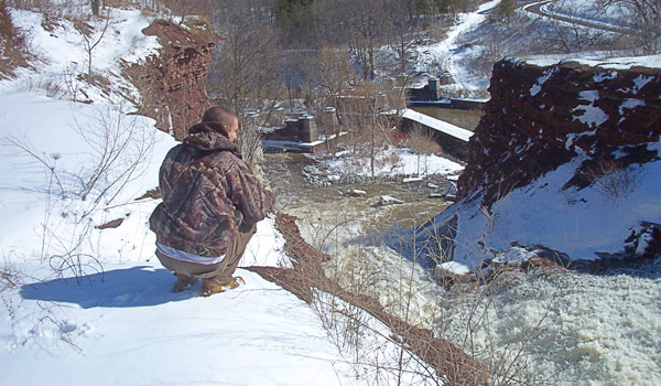
The falls is beautiful nonetheless. From the viewing area, you don’t get to see all of it, as the very top is tucked along the bend, but you see enough. The rest creates a mystery that makes you wonder what is hiding in that small chasm. That is until you open Google Maps and find out. Overall, its a 50 ft frothy cascade that emerges from a narrow notch cut in the red gorge. To the left is the turbine house for the dam. If you are fishing, and properly equipped, you may enter the waters below the falls to get a closer look. A chain and sign draped across the base of the falls discourages anyone from attempting to scale it.
This is fishing country, and the only access to this falls is via state fishing access rights. While this doesn’t necessarily apply to waterfall visitors and photographers, I doubt it will be an issue. Either way, be respectful of those casting and catching, and obey all the signs.
History
The town of Carlton was first settled in 1803 by brothers James and William Wadsworth.
In 1876, the Ho-Jack line, which connected Rome, Watertown, and Ogdensburg was opened. It ran across the gorge here just north of the falls. The present-day DEC parking lot was built on part of the track. A wooden trestle crossed the gorge above the falls. It was rebuilt with steel in 1892, and demolished in 1995.
Lake Alice, the reservoir created by the Oak Orchard Dam, was built around 1920. It was originally called Lake Carlton, then Waterport Pond, and somehow became Lake Alice. The creation of the lake didn’t result in much relocation of area residents, since seasonal flooding prevented habitation on properties adjacent to the creek. What it did do was devastate a major natural salmonid spawning route for Lake Ontario. Despite that, fishing is one of the most popular activities in this spot today (fish are now stocked by the state).
The book Historical Album of Orleans County, N.Y (published in 1879) describes Waterport’s businesses c.1875:
Waterport is situated at the confluence of Oak Orchard Creek and other creeks, in the southern portion of the town. It contains one church, a post-office, a foundry, a hotel, three store, two saw-mills, a heading factory, a blacksmith shop and a wagon shop. A cider brandy manufactory is about to be established there.
Hiking / Walking Trails
Difficulty: Easy.
Markings: Dirt and paved walkways with signs.
Distance: About 500 ft one-way.
Description: From the parking area, head west toward the power plant, which is on private property, but fishing access is allowed. There is a gravel road leading to the plant, but visitors have also carved a narrow path through the brush on the north end. Both end up going downhill and leading to the same place. I recommend taking the driveway, assuming it’s open.
These routes lead to a concrete embankment at the base of the hydro turbine house. The falls can be seen best from the end near the dirt path. Fishermen, wearing appropriate safety gear, are permitted to enter the water below the falls. How do they get over there? They walk behind the white hydro building to the opposite embankment.
Above the Falls: From the parking area head to the driveway (south) and cross it to another gravel road that heads up to an area near the dam. You can’t see the falls from here, but you can see the dam and the lake.
Map: Interactive.
Waterport Dam and Falls Interactive Map
Waterport Falls Media
Videos

Contributor Photos & Art
At this time I have not been able to get out to this site and photograph yet. In the meantime, those with suitable photos or original works of art, that would like to be featured here, please contact me. Photos, paintings, and illustrations would be subject to quality review, and not all will be accepted. Your work can be accompanied by a link to your site/store/insta.
Interesting Stuff

Lakeside State Park
Just north of here is Lakeside State Park, formerly an orchard, and now a nature park. Despite the name, there’s not much of a beach here, and definitely no swimming. But it’s a nice place for a picnic and hike if you are in the area. Check out the Lake Ontario Parks and Beaches Guide for more information and more nearby beaches.
Photography Tips
Fishermen
- There’s a high likelihood people will be fishing there. It gets the most crowded during the salmon run in November. The best times to go are in spring, during a weekday. Experiment with your photos by including a fisherman in the foreground. Be sure to ask permission.
Silky Water Effect
- To get that smooth cotton-candy look to the falls, you need to use a Neutral Density (ND) filter on your lens. The ND filter will block some of the light from entering the lens without altering the color, and thus allows your shutter to stay open longer. This blurs the water and creates a soft white gloss to the foamy areas of the falls. Check out the article for all of the details.
More tips
- See the Articles for more photography tips.
Who to Contact
NYSDEC
Region 8
6274 East Avon-Lima Road
Avon, NY 14414
585-226-2466
Brookfield Renewable
brookfieldrenewableus.com/contact-us/