Walnut Creek Falls


Location: Within the hamlet of Forestville; town of Hanover; Chautauqua County; New York.
Maps: Google Map; Topographic; Interactive map.
GPS Coordinates: Walnut Creek Falls: N 42.46907 / W 79.18072
Viewing area: N 42.46949 / W 79.18160
Directions: From Buffalo: Take US-20W for 20 miles.
In Irving, near Tom’s Takeout, take a left onto Allegany Rd/CR-119. Head south for 1.5 miles.
You will pass over I-90, and just after that, take a right onto CR-90A (Angel Rd). Follow it for 2.3 miles and it will become Dennison Rd.
3 miles later, it will become Pearl St as you enter Forestville.
A half mile later, make a right onto Main St.
Parking: While this waterfall is viewable from the road, there’s no room for parking on Walnut St without interfering with traffic. I recommend parking at the post office on Main St.
Weather
Information / Accessibility / Accommodations
Number of falls: 1
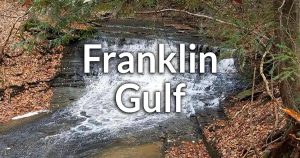
Size/Types: A V-shaped cascade with a thick limestone caprock that overhangs the brink. It’s 20 ft tall, and surrounded by trees on each side. When the flow is high, water flows over the complete caprock. When flow is lower, it will skip most of the caprock and flow over the obscured right side leaving the caprock bare from your point of view. It almost looks like water is flowing from under the rock.
Best time to visit: Year-round.
Flow: Moderate.
Waterway: Walnut Creek. It starts about 5 miles to the south in the hills above an old settlement called Chicken Tavern Corners, which is east of Arkwright. CTR-85 (Creek Rd) follows its path north into Forestville. It continues north for 5 more miles into the village of Silver Creek, where it merges with Silver Creek, and then empties into Lake Erie at George Borello Park.
Time: 15 minutes (assuming you parked on Main St and walked).
Seasons/Hours: Daylight hours, year-round.
Admission: Free.
Handicap Accessibility: The village has a paved sidewalk along this section of Walnut Rd. The view may be obscured from a sitting position.
Pets: Pets need to be on a leash in public.
Accommodations: Main St has restaurants.
Description
AKA: Walnut Falls
Despite being on private property, the perfect view of Walnut Creek Falls can easily be had from the sidewalk along Walnut Creek. The 20 ft tall V-shaped cascade is flanked by beautiful trees on each side, making it isolated from the Forestville homes surrounding it.
While it can be seen briefly by driving past, the hamlet has built a sidewalk that goes up the road a bit, so visitors can catch a glimpse of the falls, which is angled just perfectly toward the road for a perfect view. While it’s tough to park near the falls, there is parking on Main St, which is just a short walk away.
History
Forestville was originally known as Walnut Falls. Capt. Jehiel Moore, originally from Salisbury, Conn., was the first settler in 1809. He constructed a sawmill and gristmill at the falls in 1809 and 1810. A dam was constructed above the falls, with a mill pond extending to where the bridge is today. A. C. Cook eventually took over operation around 1889. The mills operated for over 100 years before being destroyed in a fire in 1929. Some of the foundations to the mills can still be found, but are on private property. The mills are often referenced as Moore’s Mill, Hanover Mill, or Cook’s Mill in various records.
Potash and pearlash were early exports for the settlement.
Forestville (along with Irving) saw business in the form of trade, mostly dealing with distribution from shipments into Silver Creek and distributing goods to southern towns. This business dropped significantly in the 1850s when the railroad took most of that business away. A fire in 1870 decimated the village, destroying most of its businesses, from which it took nearly 25 years to recover.
Hiking / Walking Trails
Difficulty: Easy.
Markings: Just follow the sidewalk.
Distance: 1/3 mile.
Description: From the parking lot by the post office, facing Main St, turn right and walk west.
Pass Chestnut St.
Turn right onto Walnut St.
Pass a cute little white house with red roof.
You will approach an area of the sidewalk that has a short yellow barrier. Keep an eye out for a clearing on your right. When you come across a clearing, look through it and to your right. The falls should be right there.
Head back the way you came.
Map: Interactive.
Walnut Creek Falls Interactive Map
Walnut Creek Falls Media
Videos

Contributor Photos & Art
At this time I have not been able to get out to this site and photograph yet. In the meantime, those with suitable photos or original works of art, who would like to be featured here, please contact me. Photos, paintings, and illustrations would be subject to quality review, and not all will be accepted. Your work can be accompanied by a link to your site/store/insta.
Who to Contact
No contact information