The Gully Preserve (Whiteman Gully)


Location: East of the village of Dansville; Town of Wayland; Steuben County; New York.
Maps: Google Map; Topographic; Interactive map; Official map (PDF).
GPS Coordinates:
- Parking: N 42.55711 / W 77.65177
- Lower Falls: N 42.55602 / W 77.65338
- Upper Falls: N 42.55788 / W 77.65124
Directions: From Dansville…
- Head south on Main St. (CR-63) leaving Dansville.
- South of Dansville CR-63 will begin bending northeast.
- At about 6 miles along CR-63 from the center of Dansville, will be Whiteman Gully Rd on your left. (Some maps refer to this as Mendoleine Rd). Turn Left on Whiteman Gully Rd.
- Follow Whiteman Gully Rd uphill for 0.4 miles.
- You will cross a bridge at 0.4 miles. This is the location for the creek. Park just past the bridge.
Parking: Just west of the bridge is a gravel pullover with space for about 4 cars.
Weather
Information / Accessibility / Accommodations
Number of falls: 2 accessible (one on each side of the road). The creek is home to 7 more waterfalls, which are upstream and on private property (inaccessible at this time).
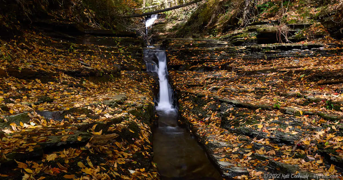
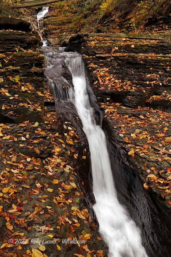
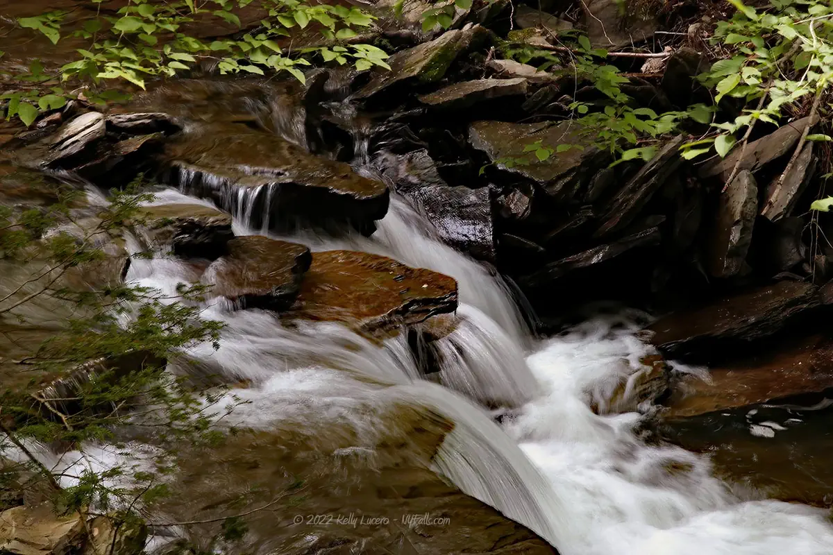
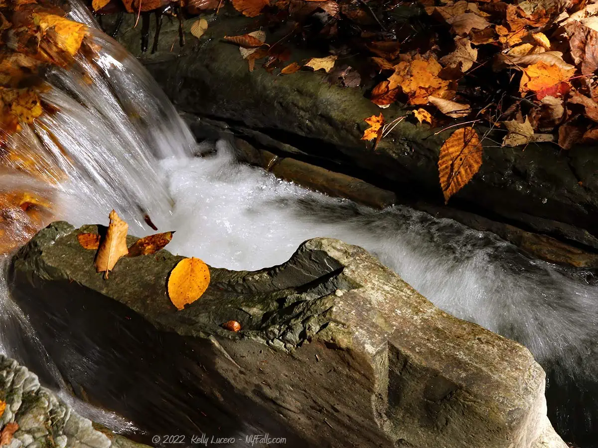
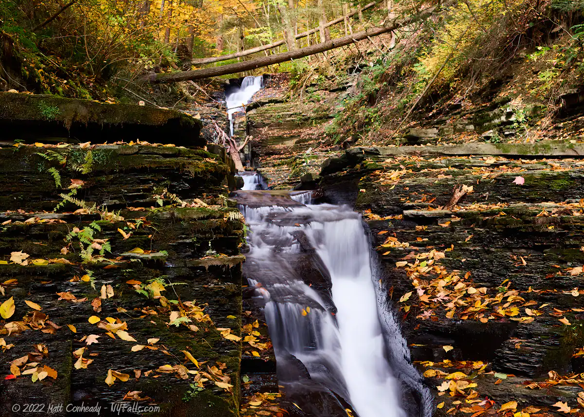
Size/Types: The upper falls, to the north, is a chute that cuts through a narrow fissure in stepped rock. In extremely high flow, water will fill the fissure and spread out over the surrounding rock, creating a more classic waterfall appearance. It is estimated at about 25-30 ft tall.
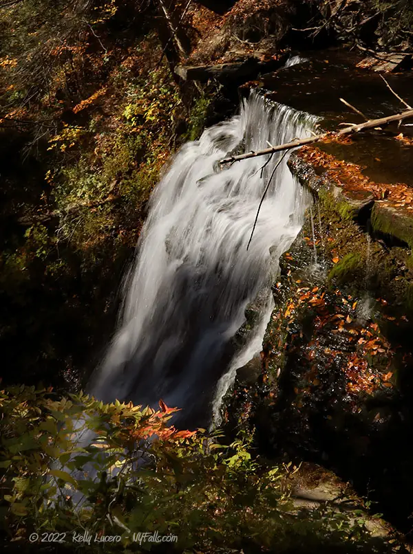
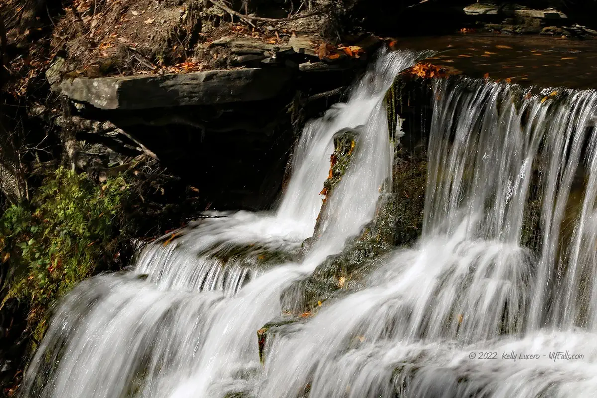
The lower falls, often referred to as Pokamoonshine Falls (or Pokey-Moonshine Falls), is a 40 ft steep cascade into a narrow, shadowy gorge.
Best time to visit: Late spring or fall, when there’s water, but not recent snowmelt or rain, which could make it difficult to cross the creek.
Flow: Moderate to low.
Waterway: The upper falls is on an unnamed tributary to Little Mill Creek. It has its origin at about 2 miles to the north. Just below the Upper Falls, this tributary converges with Little Mill Creek. Little Mill Creek has its headwater over five miles to the north in the town of Springwater. The creek is dammed just before reaching this area. The merge of the two creeks happens just before running under CR-63 at the bridge. From there, Little Mill Creek heads south, over the Lower Falls, and then turns west toward Dansville. At Dansville it turns north, merging with Canaseraga Creek just downstream from Stony Brook. Canaseraga continues north, merging with the Genesee River just past Mount Morris. The Genesee flows north through Rochester and into Lake Ontario.
Time: Take your time and you’ll be back in your car in about an hour.
Seasons/Hours: Open daily during daylight hours.
Admission: Free.
Handicap Accessibility: None.
Pets: Must be leashed and under owner control. Some dangerous cliffs, possible climbing, and no defined trails. Doesn’t seem like a safe place for pets.
Accommodations: Parking and some short unofficial trails.

Description
Also known as: Pokey-Moonshine Falls, Pokamoonshine Falls, Whiteman Gully, Whiteman Gulf.
Most commonly known as Whiteman Gully, this section of Little Mill Creek between the villages of Dansville and Wayland is home to several waterfalls, two of which are now a part of The Gully Preserve. Despite being considered to be within Whiteman Gully, most of the waterfalls, including 1 of the 2 that you can visit, are actually on a tributary to Little Mill Creek, which converges just north of the road where you will start. Little Mill Creek, which is larger, is dammed upstream from here, which diminishes its flow. The unnamed tributary that parallels it to the west, although smaller, runs steeper creating 8 distinct waterfalls as it makes its way toward Whiteman Gully Road. The one you can visit, closest to the road is a odd-looking one. It’s a chute-like falls with water running through a large straight crack down the bedrock and down multiple tiers. It takes all of 5 minutes to see and is well worth the effort, if one is traveling in the area. While it’s very close to the road, its view is obscured from that vantage point, which is probably why the blogs that have covered this location have omitted it.
Across the road to the south is a larger and wider falls, some call Pokey-Moonshine Falls. It’s a large cascade over a smoothly carved cliff into a deep and shadowy gorge. The folks who visit on hot summer days tend to gravitate here, as they have done for over 60 years, to wade in the pool below and to cool off in its showering downpour. To get to this falls, one has to walk across the creek, which may prove to be a challenge if the flow is high or temperatures are low. Getting to the bottom is best using secured rope and a bit of experience and bravery. The narrow and cool gorge walls below the falls will seclude the visitor from the world above making a very peaceful experience assuming one visits at the right time.
At this time only these two falls and their associated short trails are accessible to the public. While beautiful and serene, there’s not much here to fill a day trip for those coming from afar. Stony Brook State Park is just southwest of here and may be a more fulfilling day trip, especially for the family. The Gully Preserve, on the other hand, is the perfect stop for the waterfall and nature enthusiast who wishes to avoid the crowds and enjoy a less crowded experience close to gorgeous waterfalls.

History
The town of Wayland was first settled in 1806 by Zimmerman (no first name is on record). Historic records of the time document the hardships of the early settlers before the town was well established. One anecdote of the times can be found in the book, History of the Settlement of Steuben County, N.Y.: Including Notices of the Old Pioneer Settlers and Their Adventures, by R. S. Underhill & Co.
“In 1815, there being a scarcity of bread, I went through the towns of Springwater, Livonia, and Sparta, and thence to Dansville, in search of grain for sale, and none was to be found in those towns, nor in Western New York. People had to hull green wheat and rye for food. I found a field of rye on William Perine’s farm which was thought nearly fit to cut. I went home and got some neighbors, and with oxen and cart went and cut some of it, threshed it, and took it to the mill and had it mashed, for it was too damp to grind, and thought ourselves the happiest people in the world because we had bread.”
Edward W. Whiteman (of Pennsylvania) came to Wayland in 1822, established a farm and log house along the creek (north of the road on the west rim) and a Saw Mill on the east bank below the lower falls. The mill produced lumber here until it burned down in 1885. Over his long residency in the town, he purchased over 700 acres of land, held the position of town supervisor. Whiteman’s Gulf is the earliest documented name for this location.
An 1873 map shows a saw mill owned by J. Squires in the north reaches of the gorge. Little information could be found about its operation and exact placement. Around 1873, the village of Dansville established its first waterworks, resulting in a dam and reservoir being constructed on the east tributary north of the waterfalls. It seems as though milling operations along Little Mill Creek and its tributaries had ceased by the 1900s.
A 1952 New York Times Travel feature, titled “There is, Too, a Pokey-Moonshine Falls” by Bill Cartwright, told the story of his travels upstate to revisit this relatively unknown watering hole. By his testament, he found the waterfall of his childhood, and a photograph in the article confirms that it is indeed the lower falls of Whiteman Gully. I could find no historical documents nor maps using this moniker in reference to any waterfalls here or in New York state for that matter. A few miles to the north a Pokamoonshine Hollow exists. Now paved through with Pokamoonshine Road (formerly Pokey-Moonshine Road), the tributary does pass by this location, but no waterway runs through it. Prior to its development, this interesting geological feature was described as a deep gorge cut laterally across Clover Hill, a long North-South run of about 250 ft in height. Of course, this is not uncommon in New York, but the fact that this runs East-to-West and has no running water, is. It is suspected that as the glaciers of the last ice age receded, south to north, meltwater was blocked and cut this pathway through the hill.
Pokey-Moonshine, Pokamoonshine, Pocamoonshine, and several other variants are occasionally used to describe bald hillsides and cliffs eroded smooth, while often being devoid of plantlife. Several localized tales offer creative origins of the name, but academic sources all seem to point toward one common origin. The Algonquin terms for pohqui (broken) and moosi (smooth). The geologic traits of the locations that have taken on the name, including Poke-O-Moonshine Mountain in the Adirondacks, as well as the overlapping distribution of these places with Algonquin territories and migrations, reinforces this theory. Still, it is just a theory.
The falls have been a local hidden secret for the better part of the 20th century. While on private property, residents would visit, explore, and bathe in the waters of the gully without issue. The last private landowner of this preserve, Jocelyn Goldberg-Schaible, not only allowed visitors, she felt the need to have the land preserved and accessible for generations to come. Jocelyn gifted the land to the Genesee Valley Conservancy and under their stewardship, the parcel became a preserve open to the public in December of 2021.
Hiking / Walking Trails
Difficulty: Moderate to difficult depending on what path you take and how far you go. To see it all, getting your feet wet by crossing the creek, and climbing down a muddy cliff are both necessary.
Markings: A sign near the southern trailhead. The Conservancy says that there are no official trails, but some do exist. There are no markings, but for the most part they are straight forward to find and follow. At some point you will cross a section that may be confusing. Study the map below to know the general direction to go.
Distance: A half mile to see it all.
Description:
There are two ways to proceed north. A trail leads up from the west side of the bridge with the woods along the rim of the gorge. It passes above the Upper Falls, and then ends abruptly at the boundary of the preserve at about 0.15 miles. While it does offer some views of the Upper Falls, this long chute-like falls is largely obstructed by the surrounding rock and is best seen from below.
At the trailhead leading up the rim, instead work your way down into the gully just north of the bridge. There may or may not be a defined trail here, depending on the season. Within a few hundred feet, you will find yourself at the base of the Upper Falls.
To get to the Lower Falls (also known as Pokey-Moonshine Falls) begin at the trailhead marked with a GVC sign. This path heads downhill and is well defined. At about 0.7 mile down you will reach the creek. Find a safe place to cross and then continue downstream to the crest of the Lower Falls. If conditions are right and you are careful, you can get to the base of the falls by continuing downstream a bit. Visitors have carved a trail down the slope and a rope or two is often tied to help with the second half of the climb down. Of course, proceed at your own risk and follow safety guidelines.
None of these trails loop, so go back the way you came to get back to your car.
Map: Interactive.
The Gully Preserve Interactive Map
Th Gully Preserve Media
The Gully Preserve Video

Photography Tips
Silky Smooth Water
- To get that smooth cotton-candy look to the falls, you need to use a Neutral Density (ND) filter on your lens. The ND filter will block some of the light from entering the lens without altering the color, and thus allows your shutter to stay open longer. This blurs the water and creates a soft white gloss to the foamy areas of the falls. Check out the article for all of the details.
Shadowy Gorge and Sunlight
- The gorge is narrow and not deep enough to eliminate sun spots from your photos, so it’s best to target this place on overcast days for even lighting. If you happen to be here in the direct sun, try taking close ups of areas completely lit by sun, or totally within the shadows. Sunlight is also great for showing contrast within rocky surfaces.
More tips
- See the Articles for more photography tips.
Who to Contact
Genesee Valley Conservancy
[email protected]
585-243-2190