County Line Falls


Location: Near Hemlock Lake and Reynolds Gully; Town of Springwater; Livingston County; New York.
Maps: Google Map; Topographic; Interactive map.
GPS: Upper Falls: (N 42.67084 / W 77.58741)
Lower Falls: (N 42.67147 / W 77.58938)
Parking/Trailhead: (N 42.67628 / W 77.58659)
Directions: Take NY-15A south past the south end of Hemlock Lake. Turn onto Bald Hill Rd S, which if you are coming from the north will be a hairpin turn. Keep an eye out for it. About 100 ft up Bald Hill Rd S will be Johnson Hill Rd. Turn onto Johnson Hill Rd and within a few hundred feet you will find a gravel parking area on your right. Or use Google Maps.
Parking: For the Upper Falls, the parking lot off of Johnson Hill Rd can easily fit 6 cars. Map.
To see the lower falls, park in a gravel lot south of the falls, off of NY-15A. This is a fairly large area, but because this is parking for trailers using the boat launch, it can fill up quickly in good weather. Map.

Weather
Information / Accessibility / Accommodations
Number of falls: 2
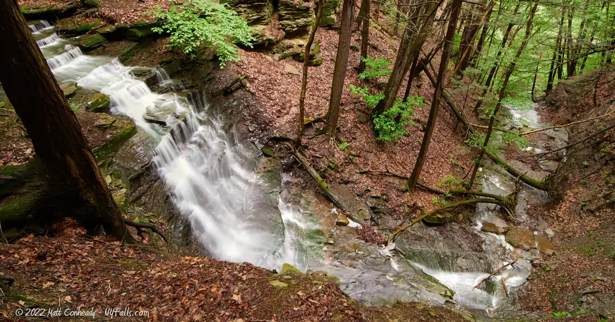
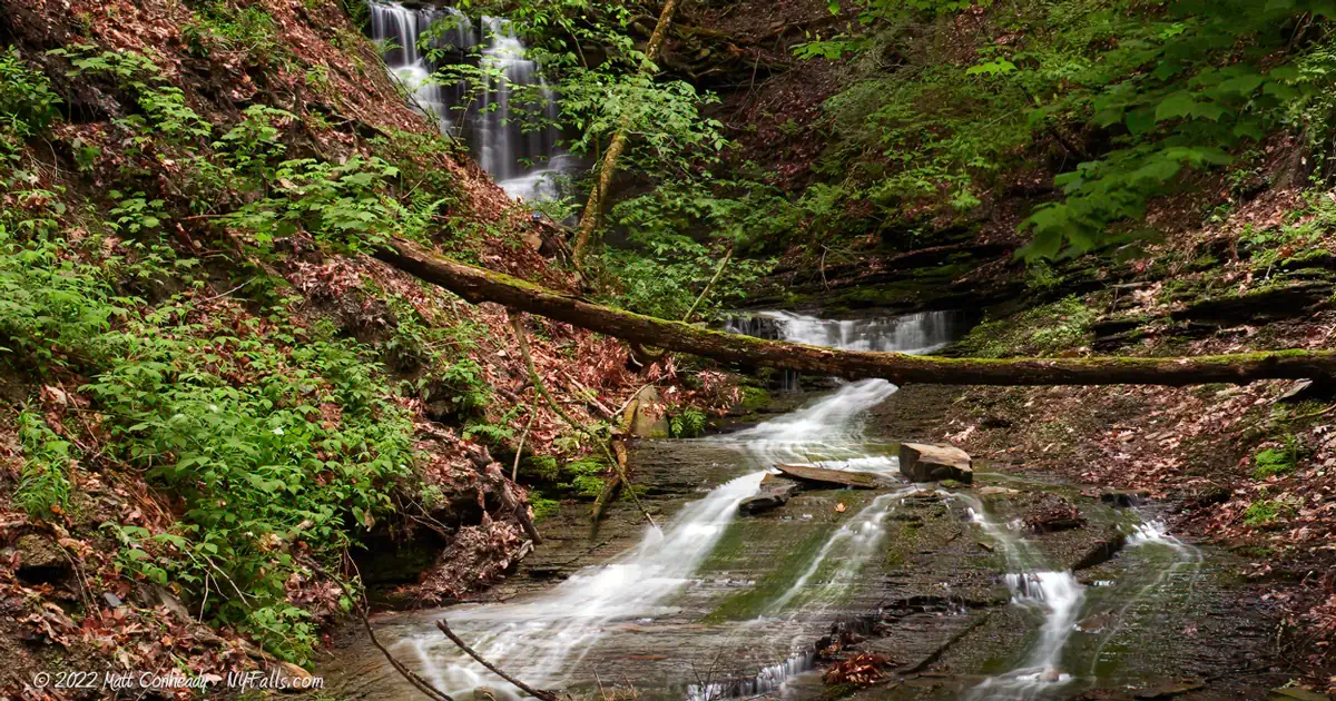
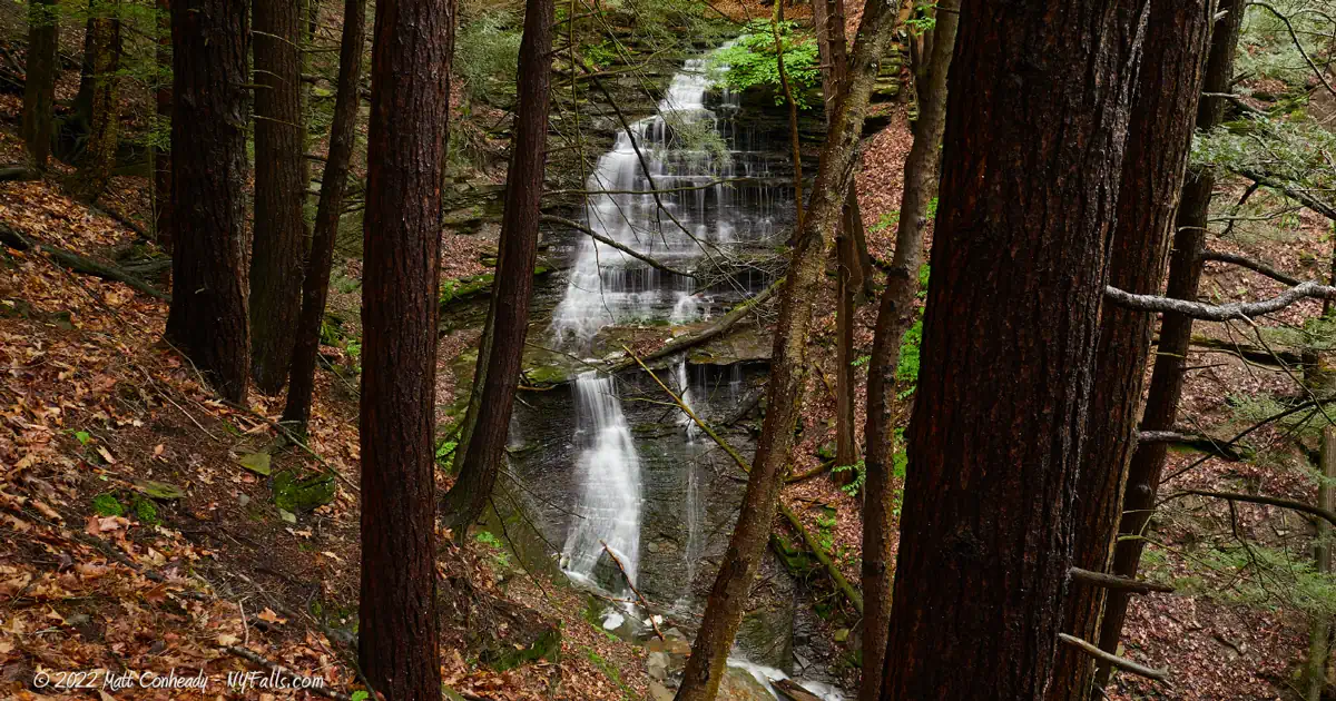
Size/Types: The upper falls is a 50 ft tall cascade. The lower falls is a cascade of about 25 ft in height.
Best time to visit: Spring.
Flow: Low. It will dry out by mid-summer.
Waterway: An unnamed tributary to Hemlock Lake.
Time: Plan for about 45 minutes to see both falls.
Seasons/Hours: Open year-round, day and night.
Admission: Free.
Handicap Accessibility: A dirt trail leads from the parking area to the upper falls. The gradation is light, but the path is uneven. Not possible for a chair, but the walk is relatively easy.
Pets: Pets are allowed, but must be on a leash at all times.
Accommodations: There is a park on the north end of Hemlock Lake that has picnic tables, restrooms, and fishing.
Description
County Line Falls is so named because it sits just south of the Ontario-Livingston County border. It’s located within the Hemlock-Canadice State Forest, a 6,849-acre preserve surrounding the two lakes and a great deal of their watersheds. The state recently acquired this land from the city of Rochester, which uses both lakes as a source of drinking water. Several seasonal tributaries dot the hillsides around the lakes, of which this small unnamed ravine is one of the larger ones.
There are actually 2 falls here. The upper falls, which is roughly 50 ft in height, and the lower falls, estimated to be 25 ft. Both are beautiful cascades down steep mossy cliffs, with small overhanging drops along the way.
A trail leads directly to the upper falls from a small parking lot to the north, making it pretty easy to see. The lower falls takes a bit of a scramble downhill, or a drive to another parking lot to the south and a hike up the ravine. Either way, it’s a pretty quick set of falls to check out.
A few hundred feet to the south is Reynolds Gully, a larger ravine, of which most is on private land. Hemlock Lake has a nice park with picnicking facilities just a short drive north.

History
An 1872 map of Livingston County shows a homestead owned by T. Reynolds on the north end of the ravine, near where NY-15A is today. A schoolhouse existed on the south end, and Dr. I. R. Norton just south of that. A map from 1902 shows the Reynolds property then owned by A. N. Johnson.
For more history, visit the Hemlock Lake page.
Hiking / Walking Trails
Difficulty: Easy to reach the top of the upper falls from the forest trail. A moderate hike up the creek (from the road) to see the lower falls. If you want to go directly from the upper falls downhill to the lower falls, despite it being a short scramble, it can be difficult.
Markings: Trailhead and signage from the parking area on Johnson Hill Rd. Other than that, it’s just a dirt trail.
Distance: A loop to the upper falls and back is about a mile.
Description:
- From the parking area on Johnson Hill Road, head into the woods at the trailhead. This trail is mostly straight and no junctions.
- At about 1/3 of a mile in, the top of the upper falls will be on your right. If this is enough for you, walk back the way you came.
- Seeing the upper falls from below will take a scramble down the hill a bit. Use caution. The falls flows best in the wet season, and that’s exactly when things get slippery.
- Heading further downhill from there will get you to the lower falls. Alternatively, you can access the base of the lower falls, avoiding the more dangerous route of going downhill, by hiking upstream from NY-15A. Park at the boat launch (across from Reynolds Gully) and head north about 1100 ft. Cross the street and walk straight up the creek to the falls.
Map: Interactive.

County Line Falls Interactive Map
County Line Falls Media
Videos


Who to Contact
DEC Region 8 Bath Office
(M-F, 8:30 AM – 4:30 PM)
(607) 622-8282
[email protected]
Enforcement Matters: (518) 408-5850 (24/7) or 911