Scoby Dam Park


Location: South of the village of Springville; town of Concord; Erie County; New York.
Maps: Google Map; Topographic; Interactive map.
GPS: Scoby Dam: (N 42.48120 / W 78.70025)
Parking Lot: (N 42.48349 / W 78.70012)
Directions: From Buffalo: Take US-219 South for 24.6 miles.
Take the NY-39 exit for Springville/Gowanda.
Turn left onto NY-39.
Turn right onto S Cascade Dr and follow for 2.5 miles.
At the end of that 2.5 miles, the road will go under US-219.
Take a right on Scoby Hill Rd, right after going under the second US-219 bridge.
A mile down Scoby Hill Rd, it will bend left.
After a quarter mile it will end at the parking lot of the park.
Parking: Park at the lot at the end of Scoby Hill Rd. There’s room for about 8 cars. Don’t park on the gravel/dirt roads you may pass on the way there.
Weather
Information / Accessibility / Accommodations
Number of falls: 1
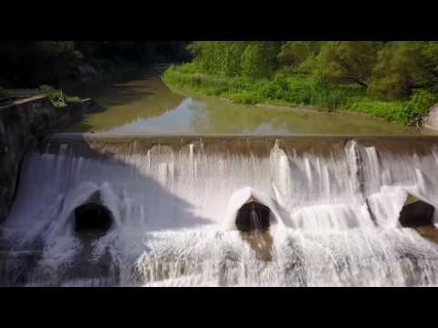
Size/Types: A 38 ft high, 128 ft long man-made concrete dam with a curvy L-shaped slope that creates a very pleasing cascade.
Best time to visit: Year-round.
Flow: Fairly good all year.
Waterway: Cattaraugus Creek, which has its origins 20 miles to the northeast at Java Lake in Wyoming County. Prior to reaching this park, the creek passes by the West Valley Nuclear Waste Site, which has yet to be cleaned up. From here it flows west for about 20 miles, passing through Irving and emptying into Lake Erie at Sunset Bay.
Time: About 15 minutes to see the dam. 30-45 minutes to hike the full trail and back.
Seasons/Hours: Daylight hours, year-round.
Admission: Free.
Handicap Accessibility: The trail is mostly dirt and gravel, but you can see the dam from the parking area. A proposed ADA fishing platform near the parking area may offer a better view of the falls in the future. An asphalt paving of the trail is also planned.
Pets: Allowed on a leash. Since this park is used frequently by fisherman, please keep your dog under control.
Accommodations: A trail; fishing access on Cattaraugus Creek; picnic tables.
Description
Scoby Dam, a unique example of early 20th century technology, is going to change drastically.
The 38 ft dam and ruins of its adjacent power facility are no longer in use, but the dam, which creates a beautiful roaring waterfall on Cattaraugus Creek, attracts many to the adjacent park. Fishing is hot here, with the sport being one of the primary reasons for visits in season. It’s also the reason why the dam will change. Like many dams of the era, it was built without consideration of the natural spawning behavior of native species. In this case the steelhead were impacted the most. To the dam’s credit, it does hold back the lamprey parasites. Unfortunately, migrating steelhead cannot make it up a waterfall 38 ft high and instead tire themselves out attempting. Fortunately, for anglers, this spot right below the dam is prime.
In 2014 a plan was unveiled by the DEC to lower the dam from 38ft to just 8ft and install a fish ladder (it’s really a ramp) to enable migrating populations to move across the dam. Measures are also planned to monitor and control lamprey movement. The 15 ft wide ramp would be on the Erie County side of the dam and include a trapping mechanism for lamprey (the trap would only be enabled during spawning season).
So if dams and their waterfalls are your thing, you may want to get out and see this one before it’s cut down in size.
History
The dam was constructed in 1924 by the Brass Brothers firm as a hydroelectric dam for neighboring Springville. It is listed on the National Register of Historic Places.
Erie County Parks acquired the land in 1998 (after the plant was decommissioned) and opened it as a conservation park, meaning it’s not slated for major development.
In 2014 a plan was unveiled to lower the dam by 30 ft (making it effectively only 8 ft tall) and include a fish ladder in order to bolster the steelhead population in the waterway. As of 2021, it appears that this project has not yet taken place.
The village of Springville and community is looking to develop the park into a “whitewater” area for kayaking, but no formal plans have been revealed.
Hiking / Walking Trails
Difficulty: Easy.
Markings: Well defined path with the creek on one side and woods on the other.
Distance: The dam can be seen from the parking area. Walking to it is about 750 ft from the parking area. The full trail is 3/4 mile, one way.
Description: From the parking area, head toward the creek and look left to see the dam.
Look for the trailhead to the south and follow it.
Along the way, there will be some clearings on the right allowing for access to the creek. See if you can get a view of the dam from any of these.
At about 750 ft, you will reach the dam site in a clearing.
After observing the dam, work your way to the south side of it to the site of the old powerhouse.
Continue south on the trail until the Miller Road bridge comes into sight. The park officially ends a few hundred feet before this bridge.
Head back the way you came.
Map: Interactive.
Scoby Dam Park Interactive Map
Scoby Dam Park Media
Videos

The video at the top of this page is by Spencer Timkey. Check out his channel for more cool drone videos.
Contributor Photos & Art
At this time I have not been able to get out to this site and photograph yet. In the meantime, those with suitable photos or original works of art, who would like to be featured here, please contact me. Photos, paintings, and illustrations would be subject to quality review, and not all will be accepted. Your work can be accompanied by a link to your site/store/insta.
Who to Contact
Erie County Parks, Recreation & Forestry
716-858-8355
[email protected]