Colden Falls


Location: In the hamlet of Colden; town of Colden; Erie County; New York.
Maps: Google Map; Topographic; Interactive map.
GPS Coordinates:
- Colden Falls: (N 42.64439 / W 78.68404)
- View from bridge: (N 42.64448 / W 78.68439)
Directions: From Buffalo: Take I-90 W toward Erie for 2.7 miles.
Keep right to take US-219 S (Orchard Park /Springville). Continue on US-219 S for 15.2 miles.
Take the Rice Rd / Colden Exit.
Turn left onto Rice Hill Rd and then around the bend continue straight onto W Tillen Rd.
Continue on W Tillen Rd for 1.6 miles and it will become Boston Colden Rd. Continue for another 3 miles.
You will reach the hamlet of Colden at which point Boston Colden Rd becomes CR-562.
The falls is just after the red corner building at the Heath Rd Bridge.
Use Google Maps to get you there.
Parking: You can park in the lot on the west side of the Colden Market & Cafe. It’s rarely full, but if it is, you can park behind the town hall, which is down State Rd.
Weather
Information / Accessibility / Accommodations
Number of falls: 1
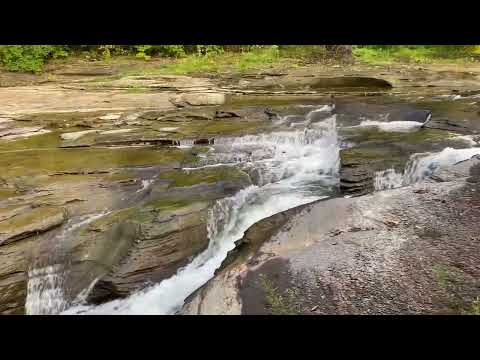
Size/Types: A 15 ft cascade along a bend in the creek. From the road, you see just the last part of that bend but 90% of the falls. Around the bend there are some small drops and holes, far less than a foot tall. Fractures in the rock layers bring the water to the inner edge of the bend. When water is low, it tends to flow just in those fissures, but when high, the falls evens out pretty nicely.
Best time to visit: Year-round.
Flow: Moderate. Sometimes may dry up to a trickle in late summer.
Waterway: West Branch Cazenovia Creek. The East and West branches of Cazenovia Creek come from the southern edge of Erie County, join together in the town of Aurora, and become just Cazenovia Creek. It continues northwest into the city of Buffalo and empties into the Buffalo River just before the Buffalo River empties into Lake Erie. near the Erie Basin Marina, Naval & Military Park, and the Buffalo Lighthouse Park.
Time: A few minutes.
Seasons/Hours: Year-round, visible in daylight hours.
Admission: Free.
Handicap Accessibility: Yes, from the sidewalk on the Heath Rd (CR-562) bridge.
Pets: Pets need to be on a leash in public.
Accommodations: Market, café, restaurant, gift shop located in the hamlet. The Buffalo Ski Club is located several miles north of here.
Description
The quaint hamlet of Colden, situated in the middle of the West Branch Cazenovia Creek Valley, gets quite a bit of traffic in the winter. The hamlet is on NY-240 between the Buffalo Ski Center and Kissing Bridge Snow Sports. While the falls itself is no major tourist attraction, for passers by it is a nice little treat for those who know how to find it.
While located on private property, it is easily seen from the Colden Veterans Bridge (Heath Rd CR-562). At about 15 ft high, it’s usually flowing, even in winter.
History
The first settler in the town was Richard Buffum (from Smithfield, Road Island) who purchased 2,000 acres of land from the Holland Purchase Company. He settled in 1810 with his wife and 11 children. They cut their own road for the last 6-8 miles of their journey to the lot. He constructed an unusually large log cabin (40 ft long by some accounts) and built a sawmill at the falls. Men of his employ come in the following months and took up land surrounding the mill. The village became known as Buffum’s Mill.
Buffum and Bloomfield constructed a gristmill just downstream in 1816. It operated until it burned down in 1868. A brick mill was built by Churchill and Shuttleworth in its place in 1870, but it too burned down in 1878. Shuttleworth built a wood frame mill in its place in 1879. This structure still exists today. It opened in 2013 as the Colden Mill Restaurant.
The town of Colden split from the town of Holland on April 2, 1827.
The village took on the name Colden in 1833 with the establishment of its first post office.
An 1866 map shows a sawmill and mill pond at the location of the falls.
Hiking / Walking Trails
Note: The falls may be on private property, but does not appear to be posted. Some people hike down or swim in the pool below the falls. If you see POSTED signs or any indication you should not be there, turn back and enjoy the view from the bridge.
Difficulty: Easy
Markings: Road signs.
Distance: A few hundred feet.
Description: From the parking lot near the Colden Market, facing the road, go right on the sidewalk, pass the market on your right. Cross NY-240 and keep on the sidewalk heading over the bridge. Look to the right to see the falls.
Map: Interactive.
Colden Falls Interactive Map
Colden Falls Media
Videos
Contributor Photos & Art
At this time I have not been able to get out to this site and photograph yet. In the meantime, those with suitable photos or original works of art, who would like to be featured here, please contact me. Photos, paintings, and illustrations would be subject to quality review, and not all will be accepted. Your work can be accompanied by a link to your site/store/insta.
Who to Contact
No contact information