Schoolmarm Falls


Location: Within Zoar Valley; east of the village of Gowanda; town of Otto; Cattaraugus County; New York.
Maps: Google Map; Topographic; Interactive map.
GPS Coordinate: Schoolmarm Falls: N 42.44526 / W 78.82761
Directions: Getting to Zoar Valley: From Buffalo, take US-62 south to Gowanda, which is the western gateway to the Zoar Valley Multiple Use Area.
Yield right onto Sandhill Rd, then turn left onto Buffalo St.
Make a right onto E Main St, then a right onto Gowanda Zoar Rd. You are now on the north side of the valley and need to get to the south. This will overshoot the falls by a bit.
Follow Gowanda Zoar Rd. for 5 miles.
Turn right onto N Otto Rd, which will cross over Cattaraugus Creek.
The next intersection will have N Otto Rd on the left, and N Otto Rd/Zoar Valley Rd on the right. Make a right onto N Otto Rd/Zoar Valley Rd. Follow it for 1.1 miles.
You will cross a tributary at a bend in the road. The falls will be right after that on your left.
Parking: There are small pullovers on the left and right sides of the falls. Be careful of traffic since this is along a blind curve.
Weather
Information / Accessibility / Accommodations
Number of falls: 1
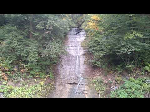
Size/Types: A ribbon cascade estimated at 70 ft. In times of high flow, it can widen significantly and become pretty frothy, which is probably why it was once referred to as Buttermilk Falls/Cascade.
Best time to visit: Spring or after heavy rainfall.
Flow: Low.
Waterway: A small unnamed tributary to Waterman Brook. It only starts at the top of the hill here, so flow is very minimal. Waterman Brook joins with Cattaraugus Creek about a third of a mile north of here. Cattaraugus heads west for 50 miles, passes through Irving, and empties into Lake Erie at Sunset Bay.
Time: A couple of minutes. There’s no hike involved.
Seasons/Hours: Year-round, day and night.
Admission: Free.
Handicap Accessibility: View from the car.
Pets: No rules are posted, but pets need to be on a leash in public.
Accommodations: None here. The closest shops and eateries are located in the village of Gowanda.
Description
AKA: Buttermilk Falls; Buttermilk Cascade; Waterman Cascade.
With over 20 accessible waterfalls spread across Zoar Valley, and several requiring dangerous hikes to find, it’s nice that the Unique Area has a handful of roadside falls that can be seen in a jiffy. Schoolmarm Cascade is one of them. While the proper name is often debated, I’ve decided to go with the less conventional one here. I do this primarily because the Buttermilk moniker just leads to confusion with the 30 other Buttermilk Falls we have in New York, but also the Schoolmarm name is not only unique, it has an interesting legend behind it, and alludes to the dangers that can be found within Zoar Valley.
This 70 ft tall cascade is the true definition of a roadside falls. It’s right up against the road, and so tall, you really have to pull over and stretch your neck to to see it. Because it’s along a very small tributary, it’s either dry or a slight trickle most of the year, but if you happen to pass it after several days of heavy downpours, it can be quite powerful and has been known to spray passing cars with mist.
History
The town of Otto was first settled as early as 1810 by Joseph Adams and his son Blinn (from Madison County), General Phineas Orr (from Hew Hampshire), and Joseph Bartlett (from Canada). At the time, it was a part of the town of Perrysburg (it separated in 1823). East Otto was spun off in 1854. Waterman Brook is named after Ira Waterman (of Cortland County) who settled here before 1819.
An 1869 map shows a sawmill at the falls, as well as one on Waterman Brook near the road.
The Schoolmarm Falls name comes from the legend that a child, trapped atop the falls, was rescued by a schoolmarm, at the cost of her own life. The falls was named after her in memoriam. Not only could I find no credible source for this story, I find it odd that if they wanted to honor and remember her, they could have named it after her, not just “schoolmarm.”

Hiking / Walking Trails
Difficulty: Easy. There is no hike.
Markings: None.
Distance: View it from your car.
Description: Coming from the west, as you drive over the bridge, the falls will be on your left. Pullover spots are on each side of the falls.
From the east: it will be on your right before you get to the bridge.
On the left side of the falls there is a makeshift trail leading a dozen feet to the base of the falls. I am not sure if this is private property or not. If you see POSTED signs, turn back.
Map: Interactive.
Schoolmarm Falls Interactive Map
Schoolmarm Falls Media
Videos
Contributor Photos & Art
At this time I have not been able to get out to this site and photograph yet. In the meantime, those with suitable photos or original works of art, who would like to be featured here, please contact me. Photos, paintings, and illustrations would be subject to quality review, and not all will be accepted. Your work can be accompanied by a link to your site/store/insta.
Who to Contact
No contact information.
This waterfall is located outside of the Zoar Valley Unique Area.