Rockwell Falls


Location: Between the hamlets of Lake Luzerne, town of Lake Luzerne; Warren County and the Hamlet of Hadley, town of Hadley, Saratoga County.
Adirondacks Region; New York.
Maps: Google Map; Topographic; Interactive map.
GPS Coordinates: Rockwell Falls: N 43.31791 / W 73.84288
Viewpoint from the Bridge: N 43.31699 / W 73.84232
Directions: From Saratoga Springs, head north on NY-9N for 14 miles into Corinth where it heads east as it merges onto W Maple St. At the intersection with Main St, make a left onto Main (which is still NY-9N) and follow it north for about 5 miles. The Hudson River will be parallel to your right along this stretch. You will cross over the river as your approach Lake Luzerne. Continue on Bay Rd (CR-16) with the river on your left. It will take you north to an intersection with School St on your right and Bridge St up further on your left. Turn left onto Bridge St. As you pass over the bridge, the falls is visible to the right (north).
Parking: You can’t park on the bridge and there are no dedicated lots for the falls. Just to the west past the bridge there is a wide shoulder for parking adjacent to Circular St. Note that you cannot park along Circular St. Park on Rockwell St. Park here.
Weather
Information / Accessibility / Accommodations
Number of falls: 1
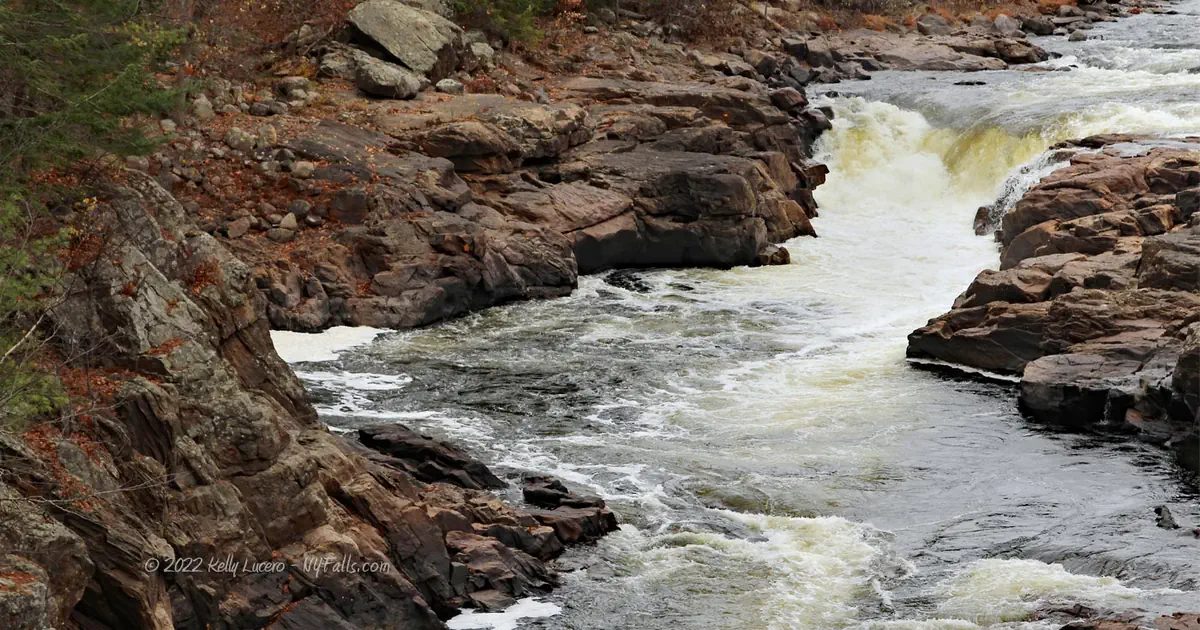
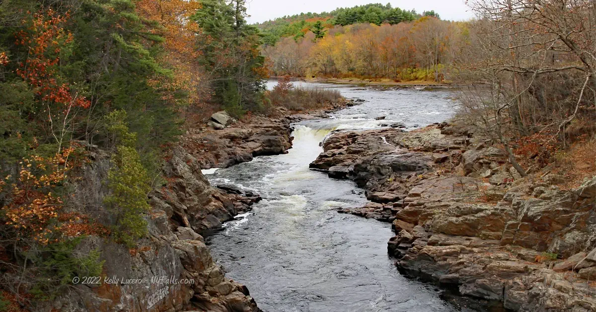
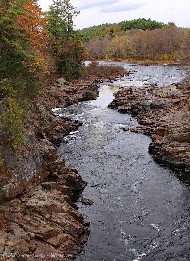
Size/Types: 10-12 ft tall, V-shaped falls between some rocky outcroppings. In lower flow the V-shape is more pronounced. In moderate flow, it looks more like a U.
Best time to visit: Year-round.
Flow: Moderate. It’s always flowing. Because of the narrow gorge in this area the current at the falls is very fast and pretty dangerous.
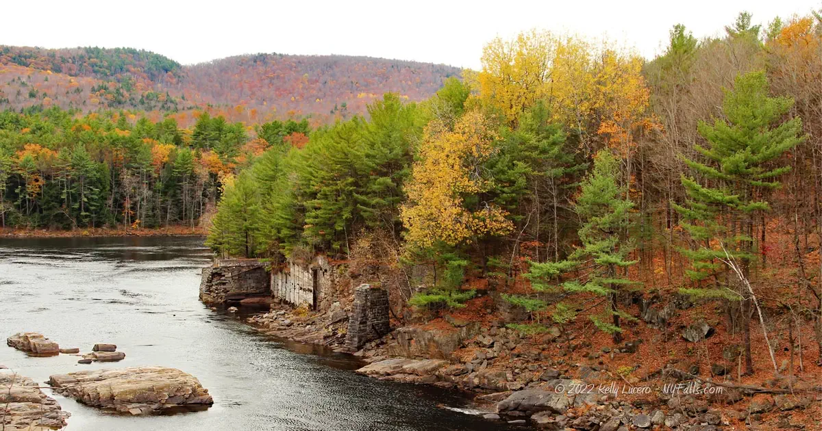
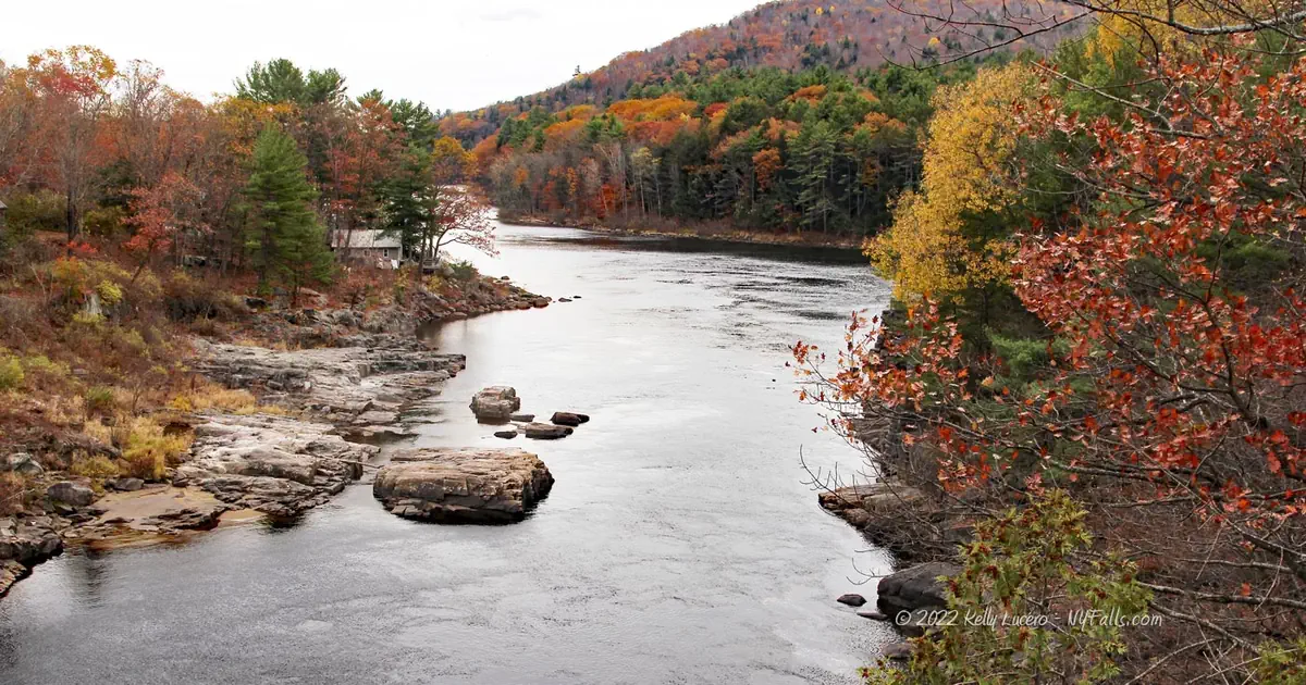
Waterway: The Hudson River, which narrows in this area as it cuts a small gorge in the valley as it passes by Lake Luzerne. The Hudson originates in the Adirondacks at Lake Tear of the Clouds, and flows 315 miles south to New York City and the Atlantic Ocean. Just south of Rockwell Falls, one of the Hudson’s largest tributaries, the Sacandaga River merges with the Hudson. This can be seen by looking south from the bridge.
Time: Just 10-15 minutes to spot the falls from the road.
Seasons/Hours: Year-round. All day. It’s not visible at night.
Admission: Free.
Handicap Accessibility: The Bridge has a paved walkway from which you can see the falls.
Pets: Pets need to be on a leash in public.
Accommodations: There are a few shops on either side of the bridge.
Description
AKA: Jessup’s Little Falls
Rockwell Falls is a relatively small waterfall on the northern Hudson River at the southern end of the Adirondacks near the city of Glens Falls. While not a particularly spectacular waterfall, as it tends to become less prominent when the water levels are moderate to high, it does offer a picturesque view and rich history. Marking the narrowest point of the Hudson River, the falls is easily spotted looking north from the Rockwell St bridge (or as some call it, the “Bridge of Hope”) and the Hudson’s confluence with the Sacandaga River can be seen from the other side. The river kicks up a bit of turbulence as it cuts through a 60 ft gorge. As the water narrows, it deepens and speeds up, making this stretch quite a dangerous one. Obviously, swimming is prohibited.
Need a closer view? Try walking over to the Rockwell Falls Public Library, which has a backyard right up against the falls.
History
Formerly known as Jessup’s Little Falls (or just Jessup’s Falls), the falls was originally named after Edward and Ebenezer Jessup, who acquired much of north and west Warren County, and Johnsburg through a deal with the native Mohawk and Sir William Johnson, (Superintendent of Indian Affairs) in the mid-1760s. They settled Jessup’s Landing, which is near present day Corinth, and built sawmills for their lumbering business, operated a ferry, and explored the region. Being loyalists, the brothers fled to Canada after local patriots burned some of the brother’s mills to the ground. They eventually became officers for the British in the Saratoga Campaign, leading raids into the Adirondacks and Champlain Valley.
The settlements of Hadley and Lake Luzerne started about the same time, with Lake Luzerne perhaps leading in 1770. While in separate townships and counties, for obvious reasons they share a lot of the same history.
Jeremy Rockwell and his wife Betsy Bird Rockwell arrived in 1800 as the first landholders in the new settlement of Hadley. Jeremy’s great grandfather, Deacon William Rockwell, immigrated to America from England in 1630. Rockwell Falls is named after this family, and the family traces their name back to Sir Ralph de Rocheville, a Norman knight. In Hadley, Jeremy served as Justice of the Peace, Town Clerk, Associate Judge, Assembly member, and state constitutional convention member at the time of its framing (1821). He eventually died as Town Supervisor (August 14, 1835). They had 12 children.
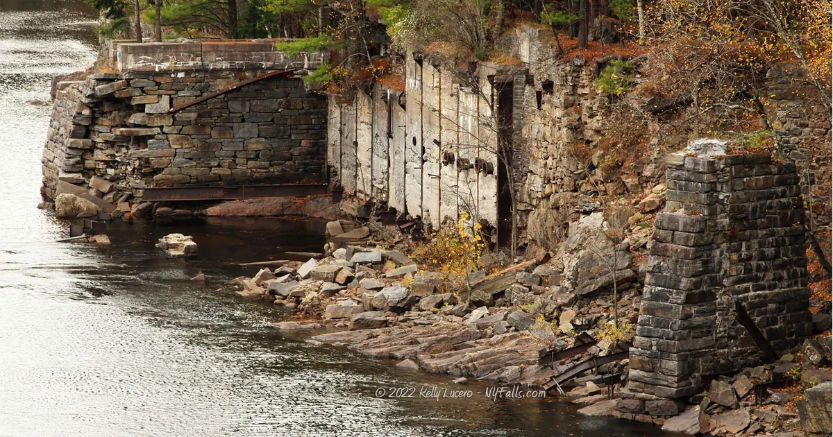
Charles Rockwell, son of Jeremy, and Marcus Gardiner (Rockwell Falls Fiber Company) constructed a papermill on the Hadley side in 1878. A dam was built below the falls to power the mill. The dam was destroyed in a flood in 1930 and was never replaced. The mill was demolished in 1936.
The first bridge connecting the two towns was constructed in 1813 and known as the Bow Bridge. The wood covered bridge was replaced with an iron truss bridge in 1885. The iron bridge was rehabilitated in 1972 and listed on the National Register of Historic Places in 1977. It was rehabilitated again in 2006.
Lake Luzerne, settled around the same time as Hadley, perhaps a bit earlier (around 1770). The town of Fairfield, its original name, was incorporated in 1972, having branched off from the town of Queensbury. In 1808 it changed its name to “Luzerne” and then to “Lake Luzerne” in 1963. The valley as a whole prospered through paper milling and tanneries through the 1800s.
The period after the Civil War brought rail trains and tourism. The Adirondack Railway arrived in Hadley in 1865 and with it brought traffic from NYC to the doorstep of the Adirondacks. Several hotels were built and prospered in both towns. Lake Luzerne, a 111 acre lake just west of the river proved to be an accessible and scenic attraction for bathing and picnics. As rail and roads were eventually extended further north, Adirondacks tourism has moved deeper into the mountains.


Hiking / Walking Trails
Difficulty: Easy.
Markings: Roads signs and sidewalks.
Distance: A few hundred feet or just drive by.
Description: From the roadside west of the falls, head east on Rockwell St towards the River and bridge. Once on the bridge, look north for the falls. Cross and look south for the confluence with the Sacandaga.
Continue east on this same road, which is now Bridge St. Turn left onto Main St. Pass the bank and head up the driveway to the back yard of the Public Library. You should see the falls from here.
Map: Interactive.
Rockwell Falls Interactive Map
Rockwell Falls Media
Videos


Interesting Stuff
Wood Pulp Mill
Lake Luzerne takes claim to the first wood pulp grinder in the United States in around 1869 by Albrecht Pagenstecher. Pagenstecher’s mills in Luzerne and Palmer Falls, Corinth were some of the largest and most successful paper millers and manufacturers in the early history of the United States and Albrecht was often referred to as “the father of the wood-pulp industry in America.”
The claim of being the “first” is not very credible as several sources point to the fact that is was the first pulp mill using American-made equipment, which was based on German patents. Pulp grinders manufactured in Germany and imported into the US, by Pagenstecher and his Partners were used first in 1867 in Curtisville, near Stockbridge, Massachusetts. Regardless, the Lake Luzerne mill is still early and an important note in American paper manufacturing history.
The site of the mill complex is now Mill Park located off of Mill St. The park has remnants of the mill, dam, a small waterfall and museum.
Brick Chimney on Main St
If you drive north on Main St, past the tennis courts, you will come across a large brick chimney on the left, standing on its own. This belonged to the Garnar Leather Work’s tannery which operated on Stewart Brook from 1967-1909. It was the predominant leatherworks of Luzerne, producing fine sheepskin book covers. The complex, which encompassed 20 acres on both sides of Main St., was demolished in 1923.


Who to Contact
Town of Lake Luzerne
518-696-2711
Town of Hadley
518-696-4797