Palmer Falls


Location: On the border of the village of Corinth, town of Corinth, Saratoga County and the town of Lake Luzerne, Warren County, New York.
Maps: Google Map; Topographic; Interactive map.
GPS Coordinates:
- Palmer Falls: N 43.24930 / W 73.82048
- Overlook Trailhead: N 43.25721 / W 73.81772
- Nearby Curtis Falls: N 43.24726 / W 73.82810
Directions: From Saratoga Springs, take NY-9N north for 14 miles to the village of Corinth.
Turn right onto W Maple St and follow it for about a half mile to Main St. Make a left onto Main St and then, shortly after, a right onto River St.
Continue straight over the bridge, which is now East River Dr (CR-16). Continue for 0.8 miles.
At Call St, turn right. In about 0.8 miles, look for a gravel parking area on the right with a blue sign for the scenic overlook.
From Corinth and Curtis Falls:
From Palmer Ave, head north on Main St. and make a right onto River St.
Continue straight over the bridge, which is now East River Dr (CR-16). Continue for 0.8 miles.
At Call St, turn right. In about 0.8 miles, look for a gravel parking area on the right with a blue sign for the scenic overlook.
Parking: The gravel lot at the Call Street trailhead holds about 5 cars. If it’s full, the shoulder on either side will work.
Weather
Information / Accessibility / Accommodations
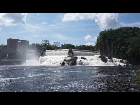
Number of falls: 1 waterfall topped by a man-made dam.
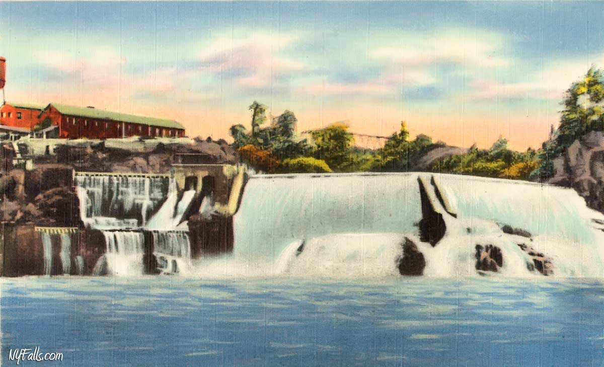
Size/Types: I could not find a solid source for the height of this falls, but it is indeed large. Some estimates put it at 65-70 ft tall, with the concrete dam taking up about half of the height. The dam on top of the falls is segmented into 2 parts, forming a V-shape. On the east side near the hydro facility there is a smooth concrete spillway. The drops from the dam are smooth, but do kick up some frothy water due to their height. Once it hits the bedrock below the dam, the water roars. The western side of the falls is especially irregular with angled striations in the bedrock, while the eastern side is a very steep cascade. In high flow, the man-made spillway contributes to the view with its own waterfall.
Best time to visit: Following Memorial Day or mid-summer after rain.
Flow: Low. The power plant diverts a great deal of the water here. In summer, it’ll likely be dry. A lot depends on both water levels and energy demand. Try to visit this one after several days of rain and when the temperatures aren’t too hot.
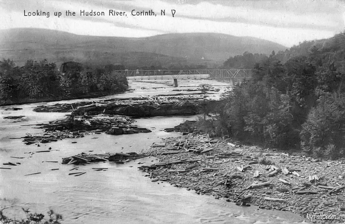
Waterway: The Hudson River. The Hudson originates in the Adirondacks at Lake Tear of the Clouds, and flows 315 miles south to New York City and the Atlantic Ocean. Just south of Rockwell Falls at Lake Luzerne, one of the Hudson’s largest tributaries, the Sacandaga River, merges with the Hudson. The river continues south 5 miles to Curtis Falls and then here to Palmer Falls. The Hudson continues south to New York City and empties into the Atlantic Ocean.
Time: 45 minutes to an hour.
Seasons/Hours: Memorial Day to Labor Day. Daytime hours.
Admission: Free.
Handicap Accessibility: This is downhill dirt/gravel. It is not accessible to wheelchairs.
Pets: No rules are posted, but pets need to be on a leash in public.
Accommodations: There’s nothing but a trail on this side of the river. Head over to Corinth for shops and eateries. See the Curtis Falls page for more information.
Description
AKA: Jessup’s Great Falls, Great Falls, Palmer Mills, Katcheboncook
Palmer Falls was one of the most industrialized waterfalls on the Hudson and a center for the booming Hudson paper manufacturing industry for decades. Today, the massive International Paper Mill complex that towered over the falls from its base on the southern shore has been demolished. It has been replaced by a compact, but still imposing 48 MW hydroelectric plant that is fed by the large modern dam that tops the falls. Innergex operates the plant at Palmer falls and the Curtis plant upstream. While Curtis Falls can be seen from the Corinth side of the river, Palmer Falls faces north, and can only be seen from the other side. Luckily Innergex maintains a public trail and overlook on the hillside that offers a pretty good view of the dam, falls, and hydro plant.
Because of the size of the plant and how it diverts the river, the flow over the dam and falls is somewhat unreliable. With the trail only being open to the public from Memorial Day through Labor Day, you are missing the high flow of early spring. Energy demand also plays into how much water is diverted through the plant. If rain is followed by hot temperatures, the region running air conditioners at MAX may mean all that excess water is going through the plant. It’s best to plan ahead and target this one after a few days of summer rain with moderate temperatures.
It’s a short drive from Curtis Falls and not too far from Rockwell Falls to the north. It’s recommended to catch them all in one shot.
History
Following the French and Indian War, Edward Jessup (1735-1816) who served under the British, received a 500,000 acre land grant from the Crown. In 1764, he and his brother Ebenezer Jessup (1739-1818) sold those land holdings and eventually acquired land along the Hudson at Warren County. Despite being one of the largest landowners in New York at the time, they purchased an additional 1,150,000 acres in the area of Hamilton County from the native Mohawk people in 1771.
From their home and base of operations in Albany, they ran a fruitful logging enterprise on the fringe of the Adirondacks, which shipped goods down the Hudson to Albany and New York City. Waterfalls, for obvious reasons, inhibited this process. To bypass Curtis and Palmer Falls, rafts stopped at Jessup’s Landing (the location of present day Corinth’s public beach) and used wagons to transport the logs around the falls. As loyalists, they fought on the side of the British during the Revolutionary War and were taken prisoner during the Saratoga Campaign (1777) and were removed to Quebec.
The settlement at the Great Falls was taking shape around the water power of the larger waterfall. The first mill on the site was a saw-mill, likely built in 1804 by Ira Haskins. It lasted until 1825, when it was replaced with a new saw-mill by Thomas, Ebenezer, and William Ide. Around 1820, a grist-mill was constructed by Thomas Harshe and a woolen-mill by George W. and Matthew Harshe.
Around 1828, Beriah Palmer (of New York City) purchased the land around the falls and the mill sat idle until 1859. Owning much of the land south of the falls, the settlement became known as Palmer’s Falls. Thomas Brown of Niagara Falls, purchased the property and developed a mill race along the falls, upgraded the mills, and established a tool shop. Things were back and running again in 1860. Brown opened a woolen factory in 1866. On the 7th of November, 1869, Thomas Brown, was leaving the woolen factory late at night with a bundle of clothing, and was mistaken as a burglar by the night-watchman. He was shot and killed. The woolen-factory burned down the following year and was rebuilt just downstream.
The town of Corinth was formed from the town of Hadley in 1818 and was named by Mrs. Washington Chapman, who opened her Bible randomly to the Epistle to the Corinthians and proclaimed “There it is. It shall be called Corinth.” It was incorporated as the Village of Corinth in 1886.
Albrecht Pagenstecher brought a new Voelter pulp grinder technology from Germany to the United States where he established a pulp mill in New Hampshire. It proved to be such a success, he bought the Voelter patent, which went on to become the dominant pulp grinding technology in the US for decades. At the time, the predominant paper raw material was cotton, which was subject to agricultural conditions and costly. Wood pulp was the future, and Pagenstecher had control of the technology to use it.
Pagenstecher licensed the patent to other millers while running and expanding his own pulping operations in the US. Albrecht and his brother Rudolph, came to New York to take advantage of the Adirondacks abundant supply of timber and the Hudson as a mode of transportation to Albany and New York City. They opened a 2-grinder mill to the north at Luzerne and an 18-grinder mill at Palmer Falls in Corinth in 1869. They established the Hudson River Pulp and Paper Company, which would grow to become one of the largest paper manufacturers in the world.
By 1870 Pagenstecher decided to grow past pulp production and into paper manufacturing, constructing a paper factory at the falls on the site of the former Brown tool shop. Paper manufacturing on site proved profitable and an additional mill was constructed on the former Brown woolen factory location (where Brown was mistakenly shot) in 1872. In 1874, the site of the relocated woolen factory was purchased by Pagenstecher’s company and used as a storehouse. The mill experienced a devastating fire in April of 1877, which left damage of the facilities and a collapse in the mill race. Repairs took more than a year to complete, but the mill carried on, grew and modernized.
Log jams were rampant at the falls, as a heavy route for logging combined with the presence of dams above the falls. Jams of millions of logs made the news and brought in tourists to see the jam and hopefully the eventual break. In 1872, a reported 2 million logs jammed the river at the falls. Another massive jam occurred in 1882. Two workers died after falling over Palmer Falls in 1879 while trying to free a log jam at the dam.
In 1898, the International Paper Company was formed from the merger of 17 pulp and paper mills in the northeastern US. Pagenstecher’s mills were acquired in that merger and he was one of the founders. He sat on the board of directors for some time. Albrecht Pagenstecher Jr grew up as a paper tycoon like his father, and was the president of the Manufacturers Paper Company of New York City and vice president of the Central Paper Company of Muskegon, Michigan.
Pagenstecher Park (a decent spot to see nearby Curtis Falls from) was once owned by the Palmers, then the Pagenstechers, was granted to the village and then opened as a public park in the 1850s and was known as “Cedars Grove.”
A modern concrete dam was constructed at the falls in 1914 and the paper business boomed into the 1960s. After tax disputes with the town and shrinking profits in the digital age, the company closed the plant in Corinth in 2002. It was demolished in 2012.
The company, which has since moved operations to Memphis, Tennessee, reported $17 billion in net sales and operated 28 mills in 2020.


The book, History of Saratoga County, NY: With Biographical Sketches of Some of Its Prominent Men and Pioneers, by Nathaniel Bartlett Sylvester, published in 1878 has a description of the river and falls:
The great falls of the Hudson lie about the middle of the eastern boundary. They form a scene of remarkably grand and picturesque beauty. The river from Jessup’s Landing runs swiftly in a series of rapids between high banks until it reaches the falls. The southern bank is a sheer rocky precipice about one hundred and twenty feet high fringed with pine cedar and hemlock at the top. The northern bank though less abrupt is a steep ascent thickly wooded. The river bed is rocky and broken and the waters of the river for fifty rods above the falls rush through a narrow channel, descending some thirty feet in the distance, and hurl themselves over with irresistible force, dashing themselves to foam and spray as they descend the ragged broken and shelving rocks that form the face of the fall. The brink of the fall is in the shape of an arc and in very low water can be crossed on foot dryshod. To the left of and above the fall stands a high dark sternly silent pile of rocks looking down with solemn grandeur upon the turbulent waters dashing themselves fretfully and impotently against its immovable base. Below the falls the bank takes a wide curve to the north and in the broad basin thus formed the great river calms its agitation smooths its ruffled surface and resumes its onward course to the sea. For beauty, and picturesque and grand effects, the scenery of Palmer’s Falls may well rank with any in the States. At one point, a few rods above the falls the river passes through a narrow channel worn in the rocks and a fourteen foot plank will span from one side of it to the other. Here tradition says that several years previous to the Revolution a white trapper was pursued along the eastern bluff, and dashing down the steep banks close to the falls, he made for this spot; and reaching it, in order to escape what was certain capture and certain death, nerved himself for the effort and vaulted over the foaming flood, alighting safely on the other side. None of his savage pursuers dared to venture the leap, and he plunged into the forest and escaped.
A half mile above the falls a deep ravine runs down to the river Its sides are steep and thickly wooded with pines It is called Indian Hollow Many years ago it was a summer camping ground for a tribe of northern Indians who came there to fish and hunt.
Hiking / Walking Trails
Difficulty: Easy.
Markings: Blue sign at the trailhead. Dirt pathway.
Distance: About 1/3 of a mile walk.
Description: From the parking area on Call Street, follow the trail south. At about 600 ft in, you will reach an open area below some large power lines. Continue south. Keep left at the fork and shortly after you will be at the overlook.
Back at the fork, the trail will lead west. Some folks have scrambled down to the river via this route.
Map: Interactive.
Curtis and Palmer Falls Interactive Map
Palmer Falls Media
Coming soon…
Contributor Photos & Art
At this time I have not been able to get out to this site and photograph yet. In the meantime, those with suitable photos or original works of art, who would like to be featured here, please contact me. Photos, paintings, and illustrations would be subject to quality review, and not all will be accepted. Your work can be accompanied by a link to your site/store/insta.
Who to Contact
Innergex/Curtis Palmer Hydroelectric
[email protected]