Pocket Falls at Edwards Lake Cliffs


Location: North of Ithaca and south of Ludlowville; in the town of Lansing; Tompkins County; in the Finger Lakes Region; New York.
Maps: Google Map; Topographic; Trail Map (PDF); Interactive map.
GPS Coordinates:
- Parking: N 42.52104 / W 76.51615
- Pocket Falls: N 42.52448 / W 76.51609
- Pocket Falls trail junction: N 42.52387 / W 76.51801
Directions (from Ithaca):
- Take either NY-13 or N Cayuga St North to NY-33 (East Shore Drive).
- Turn left (North) onto NY-33 (East Shore Drive). Follow it for about 4 miles.
- Turn left onto East Shore Circle. (Note: if you miss this turn, you will come to the other end of E Shore Cir in about 0.4 miles, then the turns below will be reversed).
- Continue on E Shore Circle for 0.2 miles to Teeter Rd.
- Make a left on Teeter Rd and follow it for a half mile to the end where you have a clear view of Cayuga Lake Basin.
Parking: Roadside parking is available at the end of Teeter Rd at Smugglers Path. There’s room for about 8-10 cars. Do not block the road. Do not block driveways of the adjacent houses. Do not park on the grass.

Weather
Information / Accessibility / Accommodations
Number of falls: 1
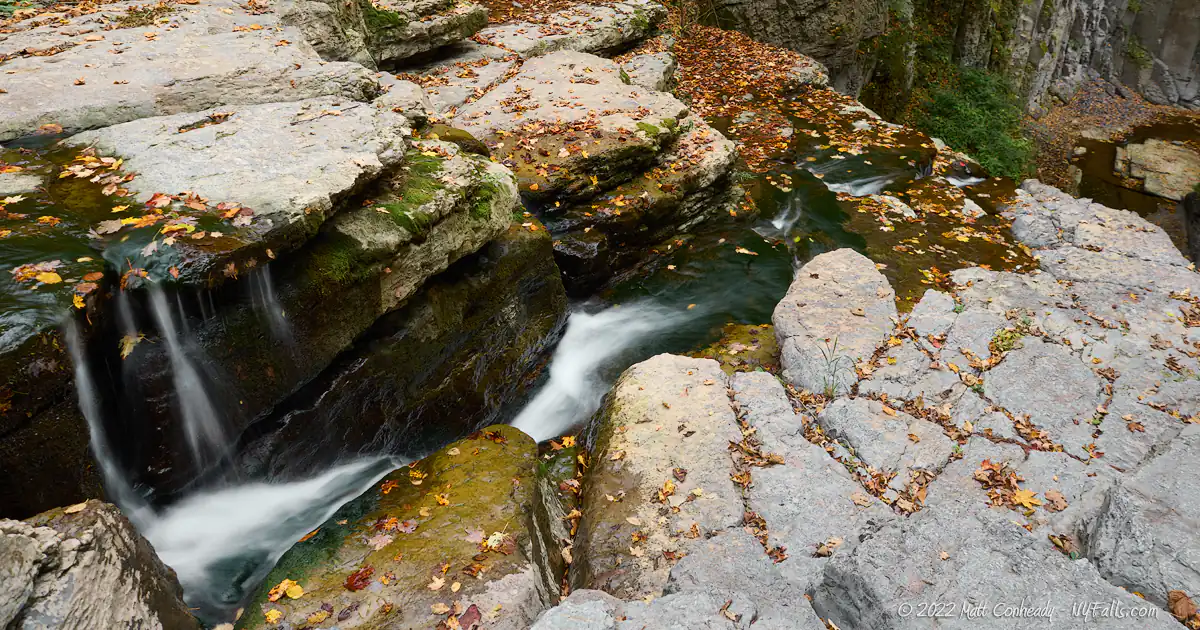
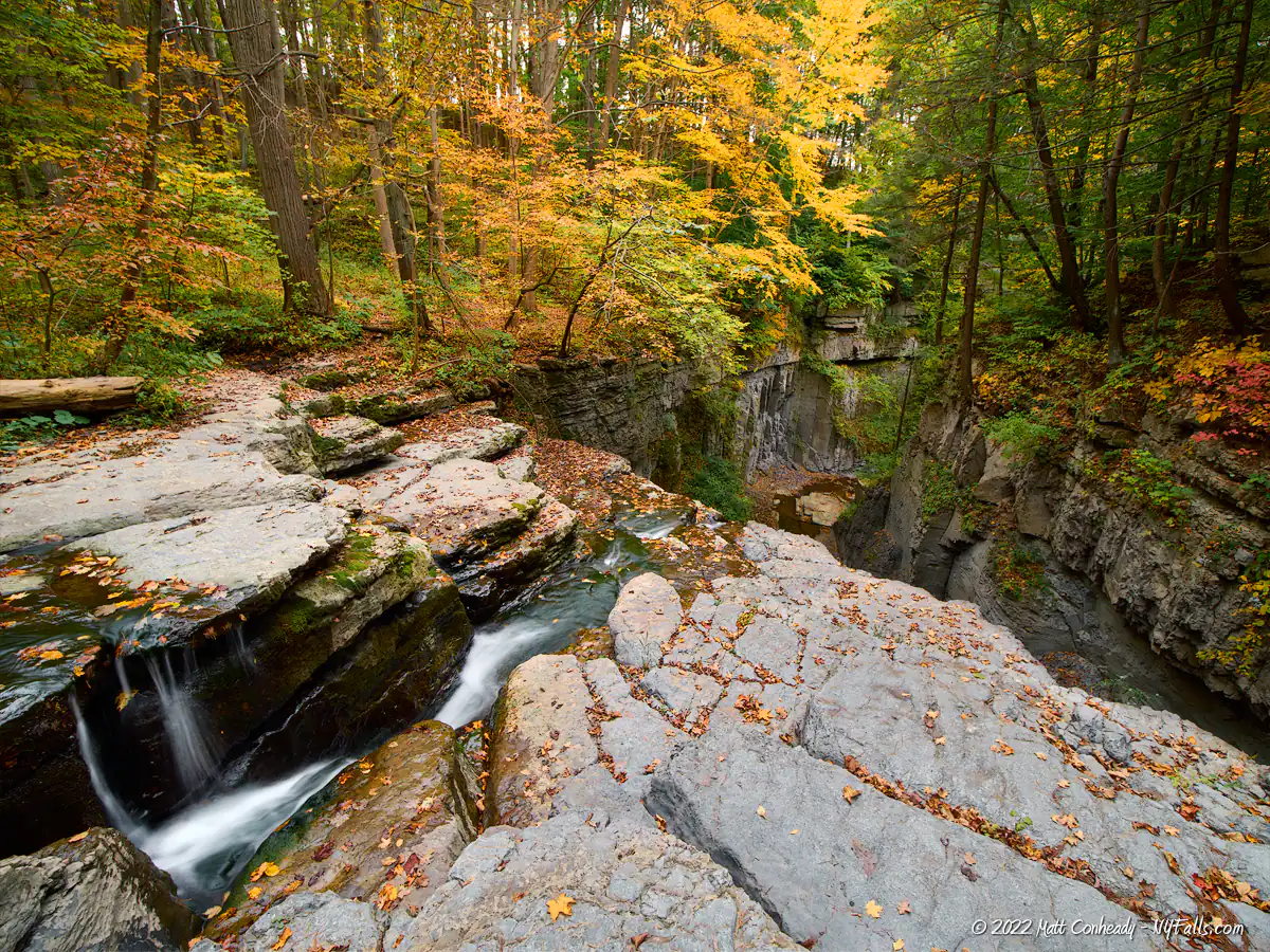
Size/Types: A 35 foot cascade over a large jagged cliff. The falls, and the surrounding cliffs feature well-defined rock joints, fracturing rock and a lot of straight edges. Unfortunately, at this time, there is no way to see the falls in its entirety.
Best time to visit: Year-round.
Flow: Moderate to low. May dry up by August.
Waterway: Gulf Creek, which begins about 5 miles to the southwest in the town of Dryden. It falls down at least 4 waterfalls in the Gulf and empties into Cayuga Lake at Portland Point, the site of an old cement plant and shipping harbor.
Time: 30 minutes to the falls and back. An hour and a half to hike more of the preserve.
Seasons/Hours: Daylight hours, 7 days a week. Closed when firearm deer hunting is allowed (Late Nov-through Dec and parts of Jan). Check here for specific dates.
Admission: Free.
Handicap Accessibility: None.
Pets: Dogs must be leashed.
Accommodations: Trails. Deer hunting (with permit) is allowed Oct to late December, then mid-January to the end of January.
Description
AKA Edwards Lake Cliffs Natural Area; Gulf Creek; Shurger Glen; Edwards Cliff
Edwards Lake Cliffs Preserve is an 84-acre natural sanctuary along the steep eastern shore of Cayuga Lake within the town of Lansing, downstream from Emilie Jonas Falls. The preserve’s upper reaches dip into Shurger Glen, a moderately-sized hanging valley above the lake, lined with steep limestone cliffs. Pocket Falls is a 35 ft cascade, the only accessible falls from several along Gulf Creek, that cascades down such a striking cliff. Unfortunately, the preserve only offers access to the top of the falls, and while several people have obtained a full view from a hike up the gully from below at Portland Point, which requires a climb up Lower Pocket Falls, (safety aside) it most definitely traverses private property. What I found striking about this location is that the view from above the falls is quite worth the short hike. The cliffs (Tully Limestone Hamilton group) are astonishingly bold with their natural joints forming sharp rectangular edges and thick overhangs, with life clinging to every corner. It’s a great place to sit and relax with the sound of rushing water echoing from the falls below your feet.
While the cliffs of Edwards Lake “Cliffs” could stand for those along the glen, it’s likely the name primarily refers to the steep cliffs along Cayuga Lake (just south of Portland Point), which the yellow trail leads to but does not offer a view of. The cliffs along the east side of the Cayuga Lake are a rare and interesting habitat for some plant species and warrant protection. One could say the same about Shurger Glen or Gulf Creek as a whole.
History
The preserve was gifted to Cornell Plantations by Donald A. and Helen T. Edwards in 2003.
Just to the north of the gorge and the likely owners of the lower, off-limits sections and falls, is the Cayuga Crushed Stone Incorporated limestone quarry and plant. Lime kilns appear on maps here as early as the mid-1800s, with a storehouse appearing at the outlet of the creek on Cayuga Lake on an 1866 map. These were likely established by Joseph Shergour, who also operated an orchard north of the gulf. This section of Gulf Creek is sometimes referred to as “Shurger Glen” (sic).
Originally a ferryboat stop known as Koplin’s Point, at the mouth of the creek became known as Shergour’s Point, likely reflecting the prosperity of his business, which had a shipyard there. Through family succession, the point eventually took on the name Collin’s Point, after Shergour’s daughter’s married name. His grandson, Sherman Collins, formed the Portland Cement Company in 1910, and from then on it became known as Portland Point. A large storehouse, rail line, and post office operated here, facilitating the cement business, which operated until 1947. The Penn-Dixie Cement Company then took over the facilities there.
Hiking / Walking Trails
Difficulty: Easy. Low gradient grass and dirt trail. The trails can be a bit confusing at some junctures. Study the guide and map below to keep this simple and avoid getting lost.
Markings: Color trail markings.
Distance: About a 3rd of a mile straight to the falls. The preserve has a web of trails that total about 3 miles.
Description: From the road and parking area head west towards the lake and trail. This is the red trail, but markers are scarce.
The trail passes a nice view of the lake beyond a small field. It turns right towards a wooded area. Ignore the first junction at the field and keep going straight into the woods after the bend.
Shortly you’ll pass another junction on the left. Keep going straight. Then another junction, skip this one too. Go straight.
The fourth junction will be with the blue trail. On maps it kind of looks like you keep going straight. In the field I found it felt more like a right. Regardless, follow the marker to the blue trail. It leads a few hundred feet towards the gorge and deeper woods.
Take a right at the next junction. This takes you down a switchback into the gorge to the top of the falls. If you pass this junction you will end up looping back to the red trail.
There’s no way down to the base of the falls from here and it’s dangerous to attempt descending these sheer cliffs. Enjoy the falls from above.
I’ve seen photos of the top of the falls from the front taken from off trail at the terminus of the blue trail at the top of the falls. When I visited in fall of 2022, this trail was a bit risky and I didn’t bother. Use caution.
To get back, go the way you came, or explore the small network of trails. The Yellow Lake View trail offers some beautiful views.
Map: Interactive; Trail Map (PDF).

Edward Cliffs Natural Area Interactive Map
Pocket Falls and Edwards Falls Cliffs Media
Edwards Falls Cliff Videos


Emilie Jonas Falls Nature Preserve
This beautiful 65-ft cascade resides on the same creek, just west of here, and you can hike down to the base of the falls.
Photography Tips
Sunsets Over Cayuga Lake
- This is a great location to get some nice views of the sunset over the lake valley. Hike the yellow trail to get to the best spot.
Full View of the Falls
- Hiking up from below is not an option here due to dangerous cliffs or traversing private property. If you are handy with a drone, you may be able to get that coveted shot.
Silky Water Effect
- To get that smooth cotton-candy look to the falls, you need to use a Neutral Density (ND) filter on your lens. The ND filter will block some of the light from entering the lens without altering the color, and thus allows your shutter to stay open longer. This blurs the water and creates a soft white gloss to the foamy areas of the falls. Check out the article for all of the details.
More tips
- See the Articles for more photography tips.

10 Must-Visit Waterfalls Around Ithaca, NY
A selection of the most popular and accessible waterfalls around Ithaca in the Finger Lakes Region of New York.
Who to Contact
Cornell Botanical Gardens
607-255-2400
[email protected]