Cayuga Shores WMA (Bell Station Preserve)

Location: On the east side of Cayuga Lake; town of Lansing; Tompkins County; Finger Lakes Region; New York.
Maps: Google Map; Topographic; Brochure (PDF); Interactive map.
GPS Coordinates:
- First waterfall: N 42.61901 / W 76.64107
- Second waterfall: N 42.61805 / W 76.64027
- Third waterfall: N 42.61635 / W 76.63960
Directions: From Ithaca, take NY-34 north to South Lansing, then NY-34B (Ridge Rd) north for 8 miles. Go left onto CR-185 (Lake Ridge Rd) and then just under a mile, make a left onto Nut Ridge Rd. Follow it to the end.
From the the north, take NY-90 south to King Ferry. Continue straight onto CR-157 (Lake Rd) and follow it for a half mile to Nut Ridge Rd. Make a right and go to the end of the road.
Use Google Maps to get you there.
Parking: Roadside parking at the end of Nut Ridge Road. Do not park in front of the entrance to the preserve. Do not block the driveway across from the preserve. It’s a steep hill so be sure to engage your emergency brake.

Weather
Information / Accessibility / Accommodations
Number of falls: 3 waterfalls along the main trail. There are a few smaller ledges upstream and mostly off-trail. Not really worth seeking out.
Size/Types: The first waterfall, is a small 5 ft shelf, over which flows a seasonal creek. You walk over this early in the hike and if you had an easy time passing it (there is no bridge or boardwalk) then it was likely dry.
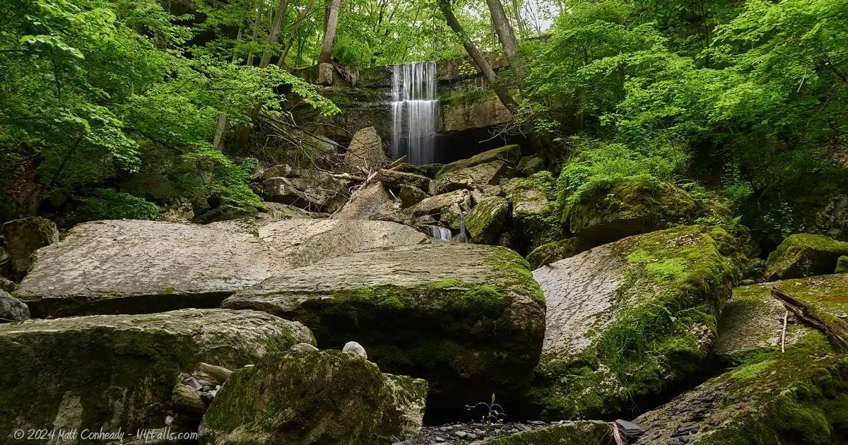
The second waterfall is the waterfall that defines this preserve. At over 40 ft in total height, it starts out with a 15-20 ft drop down a large shelf of Tully Limestone and onto a pile of massive fallen stones. It continues to wind around, under, and over those and the debris for another 20-25 ft. This stream can also be considered seasonal, drying up by late spring.
The third waterfall is a smaller version of the second, at about 2/3 the height and only a small stone pile at its base. It’s a seasonal stream and often a trickle on most days.
Best time to visit: During snowmelt, in very early spring, or after a bout of heavy rain that will thoroughly soak the ground in the region.
Flow: Very low.
Waterway: The preserve spans a series of unnamed runoff streams that go directly into Cayuga Lake.
Time: From the parking area, you can walk the trail that skims the tops of all three falls in 20 minutes or less. Allow for about an hour or more to take the trail lower in the park to the waterfront and a hike up at least one of the small gorges.
Seasons/Hours: Open from dawn to dusk, daily.
Admission: Free.
Handicap Accessibility: There are no chair accessible trails or facilities here.
Pets: All dogs must be on a leash and kept in full control by their owners. Please do not allow your dog to chase wildlife or intimidate other visitors.
Accommodations: Fishing, hunting, trapping. The nearest shops and eateries are just to the northwest in King Ferry. Restrooms, and picnicking facilities can be found 15 minutes to the north at Long Point State Park.

Description
In June of 2024, the DEC took over management of Bell Station Preserve. Along with that they have changed the name to Cayuga Shores Wildlife Management Area.
Cayuga Shores Wildlife Management Area is a remarkable natural area located on the east side of Cayuga Lake, at the northern end of Tompkins County, 15 miles north of Ithaca. Spanning over 470 acres, it features wooded hillsides, grasslands, several small gorges with waterfalls, and 3,400 feet of undeveloped shoreline. The WMA is one of the largest continuous tracts of undeveloped land on the eastern shore of Cayuga Lake. It was once slated for development but was preserved through the efforts of conservation groups and the local community. Today, it stands as a testament to the value of preserving natural habitats for future generations.
From the parking area, a short trail takes visitors through the woodland, crossing over the tops of three small streams, the middle of which forms a small gorge and moderately-sized waterfall. While all three streams have waterfalls, they tend to dry up very quickly. The largest of them flows a bit longer into the spring, and when you catch it with a decent torrent, it can be well worth the trek. We had to visit several times, with one attempt being after a week’s worth of rain, before we found the largest stream to have just enough water flowing for it to be photogenic. Even with just a little water, it’s an exhilarating sight. The water pours over a massive overhanging slab of Tully Limestone, drops over a shallow cave, and then gets tangled in a massive heap of fallen boulders as it winds down towards the beach, drowning out all surrounding sounds and creating a peaceful place to relax and photograph.
Trails descend from the main artery that crosses the crests of each waterfall. They converge near the lake where an opening reveals a small natural beach with a beautiful view of the lake, and no shortage of skipping stones. From there, a trail extends along the shoreline for the length of the property, with small areas here and there to scramble down closer to the lake. From this trail, visitors can creek-walk up the streams. I found only the largest one (near the wooden footbridge) to be worth the trek up. The rest may be fruitless unless there is so much water flow that, well, the trek up would be a wet and difficult one.

Cayuga Shores WMA Media
Bell Station Preserve Audio
2nd Waterfall in low flow
Cayuga Shores WMA Preserve Video

Cayuga Shores WMA Photos
A friendly reminder that the photos on this page are under copyright of the creator and unauthorized commercial use will result in a bill being sent for license fees. I do grant you the right to use an image from this page (commercial or non-commercial) as long as you link back to this page.
History
The property was originally acquired by New York State Electric & Gas (NYSEG) for a nuclear power plant, but those plans never came to fruition due to resistance from the local community. In 2021, NYSEG announced plans to auction the property to the highest bidder and a grassroots effort led by the Finger Lakes Land Trust to acquire and preserve the land began. Civic groups, elected officials, and a petition of over 4,000 signatures called for the cancellation of the auction, and the governor responded by securing a commitment from NYSEG to cancel the auction and instead negotiate directly with the Land Trust for the sale of the entire 480-acre property.
The Land Trust had been pursuing the conservation of Bell Station for several years. Their interest was shared by the New York State Department of Environmental Conservation (DEC), which designated the Land Trust as its agent to pursue acquisition of the land. In May 2022, the organization successfully purchased the property and opened at as Bell Station Preserve. In partnership with the Town of Lansing, the organization is also exploring the feasibility of utilizing 200 acres of the upper property for solar energy production, while the lower portion along the lakefront was over to the state DEC for management on June 3, 2024. As a part of that handoff, the DEC designated the property a Wildlife Management Area (now allowing hunting, fishing, and trapping) and change the name to Cayuga Shores Wildlife Management Area.
In 2023, the Land trust began the process to acquire the adjacent 110-acre Cedar View property just north of the preserve, on the other side of Nut Ridge Rd. The property was the home to Cedar View Golf Course, which operated for more than 50 years before closing in 2021. The plan for this property is to expand the existing meadowlands to create habitats for migratory songbirds.

Hiking / Walking Trails
Difficulty: Easy to moderate. Well through spring many spots along the trail can get muddy. In fact, if you are visiting for the falls, you’ll want to plan for wet conditions. At a few points along the trail, you’ll need to cross the small streams that span the park. The higher the water, the likelier the falls will be flowing, the more wet your feet may get. If you choose to take the trail down to the lake, a very short part at the end of that trail is a steeper gradient than the trails above.
Note: as of June 3, 2024 the DEC has taken over management of this former preserve and hunting is now allowed. Be sure to wear bright clothing when hiking during hunting seasons.
Markings: Well-defined dirt path. No blazes as of 2024.
Distance: If you walk all of the recommended hike, it’ll be about 1 mile one way.
Description: Our recommended walk takes you directly across the streams just above each waterfall. Then it heads down towards the lake. If water is flowing, you may also opt to creek walk up at least 1 of the streams to get a close look at the falls.
- From the Trailhead at the end of Nut Ridge Rd., head into the preserve and continue south. (Follow the Green trail marked on the map below).
- At about 350ft, you will cross over the first stream. The waterfall is just right of the trail. If water is trickling over it, that’s a good sign.
- Shortly after the stream, there will be a fork on your right. This leads down to the lake. You’ll return to this junction later on. Continue on.
- You will then pass another junction with a trail on your left. This heads upland. Continue on the current path.
- 300 ft after the last junction, the trail will reach the second, and largest, waterfall.
- Walk upstream a little until you see the trail continue on the other side. Cross the stream and head uphill.
- About 600 ft after the 2nd falls you will find yourself above the 3rd falls. You can cross this stream and continue another 300 ft to the end of the trail, but there’s nothing left to see here. Turn around and head back to the second junction.
- Once at the second junction (after the larger waterfall) turn left and head downhill. Note that people have blazed some shortcuts down, so there may be additional junctions in this area. Don’t worry, just head on whatever trail leads down. They all lead to the same spot.
- Head southwest and down towards the lake. After about 550ft the trail will split. One path is a bit steep. The other switches back a little to make the ascent a bit easier. When you have reached the bottom, you should see an opening in the woods revealing the lake. There’s also a small wooden footbridge going over the stream from the second falls.
- If you are up for it, creek walk up this stream to see the 2nd falls from below.
- Cross over the footbridge and follow the trail south to the 3rd stream. If water is flowing, creek walk up to see the 3rd falls from below.
Retrace your steps or use the map below to get back to where you started.
Map: Interactive; Brochure (PDF).

Cayuga Shores WMA Interactive Map
Interesting Stuff
Cedar View Golf Course (abandoned)
Across Nut Ridge Road is the former Cedar View Golf Course. The 9-hole course, designed by Earl H. Larsen of Cayuga County, opened in 1965 and closed in 2021. The course was noted for being a great course for beginners and a favorite place for locals to play. As of 2024, the Finger Lakes Land Trust is in the process of acquiring the property and adding the land to the preserve. The namesake cedar trees that line the course will likely be removed as the property transitions into a meadowland habitat for migratory songbirds.
More Cayuga Lake Parks, Beaches, and Preserves
Our guide to all the spots to enjoy the second largest of the Finger Lakes, from Montezuma National Wildlife Refuge in the north to Ithaca and its many gorges in the south.

Photography Tips
Watch the Weather
- These waterfalls dry up fast. Plan to visit this park either during snowmelt or watch the weather for a few days before you plan to visit. You are going to want the ground to be saturated before taking a chance on these falls.
- If you do happen to visit when water is ample, you are going to need to wear water shoes. The trail passes over 2 of the streams, and if the water level is high, a creek walk up the small gorge is likely going to result in wet feet.
Silky Water Effect
- To get that smooth cotton-candy look to the falls, you need to use a Neutral Density (ND) filter on your lens. The ND filter will block some of the light from entering the lens without altering the color, and thus allows your shutter to stay open longer. This blurs the water and creates a soft white gloss to the foamy areas of the falls. Check out the article for all of the details.
More tips
- See the Articles for more photography tips.

10 Must-Visit Waterfalls Around Ithaca, NY
A selection of the most popular and accessible waterfalls around Ithaca in the Finger Lakes Region of New York.
Who to Contact
DEC Region 7 Cortland Office
M-F, 8:30AM – 4:30PM
607- 753-3095
[email protected]
Search, rescue, wildfire, and enforcement matters
911 or 1-833-NYS-RANGERS (1-833-697-7264)


