Waterfalls of Partridge Run WMA


Location: In the Partridge Run State Wildlife Management Area; town of Berne; Albany County; New York.
Maps: Google Map; Topographic; Interactive map; WMA Map by Andy Author; DEC map (east); DEC map (west).
GPS Coordinates:
- Parking for the North Falls: N 42.57459, W 74.15527
- North Falls (upper): N 42.57435, W 74.15439
- North Falls (lower): N 42.57407, W 74.15304
- Parking for the South Falls: N 42.56176, W 74.15081
- South Falls (upper): N 42.56238 W 74.14804
- South Falls (lower): N 42.56365, W 74.14735
- Waterfalls at the entrance to The Gulf (approximate): N 42.57833, W 74.14855
Directions: From Albany:
Take NY-443 west for 13 miles into Clarksville.
Make a left onto Cass Hill Road (CR-11) and follow it past Hannacroix Ravine and through Reidsville (about 4 miles). It’ll become NY-85.
You will come to a fork with NY-143 on your left and NY-85 on your right. Keep right on NY-85.
Follow NY-85 west for 6.6 miles until you reach the Rensselaerville Body Shop and the junction with Shufelt Rd.
Take a right onto Shufelt Rd and then an immediate left onto CR-6/Ravine Rd. Follow it north for 2.5 miles.
This will get you into the first parking area as you enter the preserve to the south.
Parking: Use the parking lot on the right side of CR-6/Ravine Rd immediately as you enter the preserve. This lot is for Partridge Run and will put you right at the trailhead for visiting the main/south falls. For the other falls, check out the trail section below.
Weather
Information / Accessibility / Accommodations
Number of falls: There are considered to be 7 distinct waterfalls, although the largest one could be easily categorized as multiple falls based on your requirements. There may be several more runoff falls and some yet to be re-discovered within The Gulf.
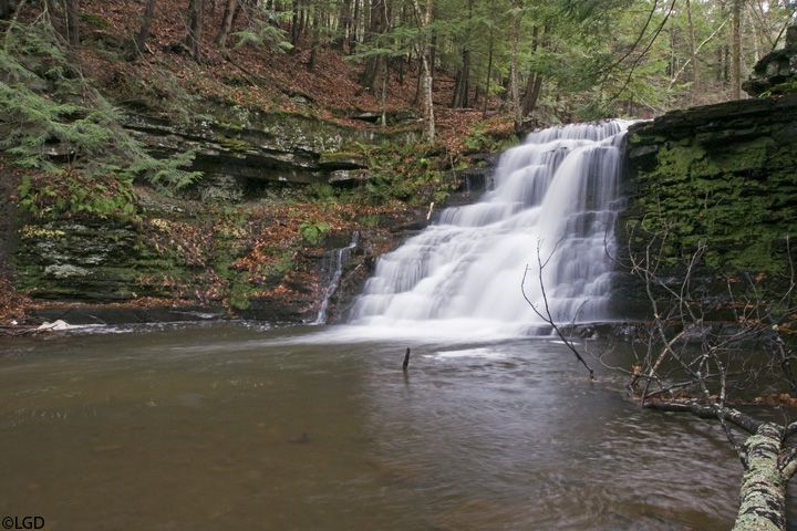
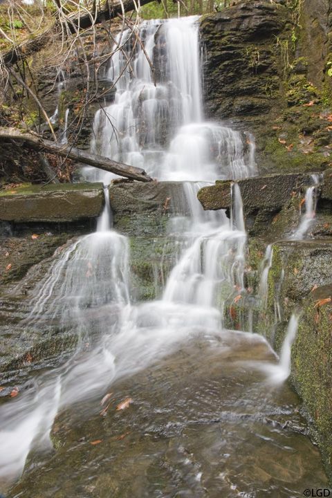
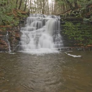
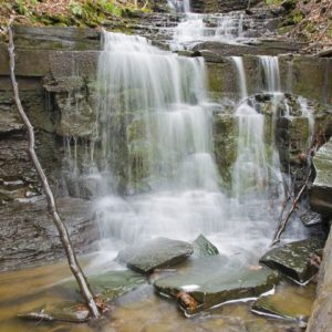
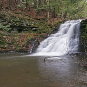
Size/Types: Cascades that look typical to the CNY/Finger Lakes region. They range from 4 to 15 ft in height.
The southern falls (on Switz Kill) are 8 and 12 ft high.
The northern falls are 10 ft (a 6 and 4 ft drop), and a 24 ft (two 12 ft drops) tall. There is a series of small ledges located by the northern falls.
Similarly sized falls have been reported at the top of The Gulf, at least 2, but details are slim as the terrain is off-trail and not well documented at this time.
Best time to visit: Warmer months as you may need to traverse the creek to get a good view. Avoid dry days as the northern falls will tend to dry up quickly.
Flow: Northern falls are low. Southern falls are moderate. The Gulf is low.
Waterway: These are all tributaries to Switz Kill, which has its source to the east at Onderdonk Lake. The name’s origins come from the region’s first settlers, who were Swiss. Switz Kill flows northwest meeting Fox Creek just west of Berne. Fox Creek flows west into Schoharie County where it turns northwest, eventually emptying into Schoharie Creek at Schoharie. Schoharie Creek flows north to the Mohawk River, which then takes the water back eastward through Schenectady and into the Hudson River. The Hudson flows south to the Atlantic Ocean and New York City.
Time: Plan for a few hours.
Seasons/Hours: The preserve is open year-round; daylight hours. Note that hunting is allowed in this preserve.
Admission: Free.
Handicap Accessibility: None.
Pets: Allowed.
Accommodations: Trails; hunting; trapping; fishing.
Description
The Partridge Run Wildlife Management Area consists of 4,500 acres of upland and wetland habitat and home to several tributaries to Switz Kill. Located in the Helderberg Mountains, an escarpment with geologic ties to the Onondaga and Niagara Escarpments that create those regions’ dramatic waterfalls. Managed by the state DEC for the purposes of wildlife management, wildlife habitat management, and wildlife-dependent recreation, it is home to several waterfalls in 3 distinct locations within. 2 of those locations are widely known and often visited for their waterfalls. A third, known historically as “The Gulf” is a steep ravine in the northern reaches of the area, and has been shown to have at least 2 waterfalls at the top, with possibly more to explore and re-discover below.
One of the better locations in Albany County for seeing several waterfalls in close proximity and in natural surroundings, Partridge Run is on the list for many CNY waterfall enthusiasts. While not terribly difficult to get great views of the falls, the short but often off-the-path treks are still exhilarating and adventurous. The Gulf location is relatively undocumented online and in modern guide-books and potentially holds more waterfalls than the 2 that are known.

History
The land that is now the WMA was mostly used as farmland since the first Swiss and Dutch settlers arrived in Berne in the late 1600s. Peter Ball was a descendant of one of those settlers and had a farm near The Gulf. He was a part of the Anti-renter movement and his refusal to pay rent on his land went to state Supreme Court in 1859. He lost and he and his family were forcibly removed from their home in the middle of a blizzard in 1860. An account is written in Bi-centennial History of Albany: History of the County of Albany, N.Y., from 1609 to 1886 · Volume 1, by George Rogers Howell & Jonathan Tenney (1886):
On the 17th day of February, 1860, one of the coldest days of the winter, the principal adventurer in the claims accompanied by the Sheriff and his posse, some fourteen or fifteen in number, armed with pistols and clubs, and handcuffs to bind any that might be found to oppose made, a sudden descent upon the farm and premises of Peter Ball, situated on the Helderbergs, near the village of Berne. The farm had been his and his forefathers for generations but then and there in the midst of a furious mountain snow-storm, they cast him with his family, consisting of his wife a sick daughter, and an aged colored servant, from the dwelling out upon the public highway.
The value of this farm, within the very limits of the village, with its new, convenient and handsome dwelling house, and other improvements, made by Peter Ball himself, was very considerable. It was one of the most desirable and picturesque places on the Helderbergs; and as the poor, old people the sick daughter and the aged servant were forced to leave, their cries and their tears touched many a tender heart.
It may be truthfully asserted that when the Patroon sold his lands on the Helderbergs, there was not probably an acre that was worth more than twenty five cents. The value was given afterward by the buildings and other improvements put upon the lands by the purchasers.
It was necessary it was said to make an example of Peter Ball, because he had been a leading and persistent anti-renter, for the influence it might exert at the time upon other anti-renters to come forward and settle exacted claims.
This land was once managed by the federal government as a game management area. A wildlife Research Center conducted studies onsite. They also maintained spruce and pine plantations here. It was transferred to the state of New York in 1962.
Hiking / Walking Trails
Difficulty: Moderate. There are two well-known and short hikes into small ravines. Each requires a bit of a scramble down. More so if you want to get to the base of each waterfall. You could hike the road from the south to the north ravines, but I recommend you just drive as there are parking lots at each and not much to see along the way.
Exploring “The Gulf” area further than the first 2 falls is likely difficult.
Markings: Some trail/road signs/color blazes.
Distance: Seeing the north and south falls is less than a fifth of a mile in total (ignoring the drive between them).
The Gulf is about a half mile long.
Description
The Southern Falls at Partridge Run Rd: From the parking area at the south of the preserve, head east on the dirt Partridge Run Rd.
At about 0.1 mile, you should begin to hear the first waterfall.
Keep an eye on your right, as you will need to head cautiously to the rim of the ravine to see it.
The next waterfalls, a grouping of two, will be about 0.6 miles further down. If conditions are right, you may be able find a safe path to get down below the falls. Obviously you do this at your own risk and have read through this.
Head back the way you came.
Drive to the next location.
The Northern Falls along the Redbelly Trail: From the lot at the southern falls, drive north on Ravine Rd for just about a mile until you reach Sickle Hill Rd on your left.
Park along the side of the road at the junction.
The Redbelly Trail is a snowmobile trail that heads east from here. Take it into the woods and keep an eye out for the first falls on your left at about 100-125 ft in. A smaller falls will follow as the ravine gets deeper. You can scramble down into the ravine to get to the creek bed and an old dam, now breached. Creek walk about 150 ft further downstream past small drops in the creek to a pair of 12-15 footers. Getting to the base of those falls depends on conditions. Most cross over to the north side and then make their way down. Use caution and proceed at your own risk.
Go back the way you came.
The Gulf: The Gulf is such a steep ravine that it is mentioned in some local history books as being one of the defining features of the county. At this time, I am aware of 2 sizable waterfalls near the top. I could not find much in the way of what else the half-mile ravine contains within. If you choose to head off-trail and explore it, follow the safety guidelines, and do so at your own risk.
Head north on Ravine Rd from the parking area at Sickle Hill Rd; it’ll turn right.
Park on the side of the road at Kingfisher Rd.
On foot, follow Kingfisher east. The Gulf will be on your left.
At about 0.10 of a mile in, The Gulf begins to steepen and turn north. You need to find a way to scramble down before this point.
The first 2 waterfalls are within the next 0.2 miles down. Beyond that is unknown to me.
Map: Interactive; WMA Map by Andy Author; DEC map (east); DEC map (west).

Waterfalls of Partridge Run WMA Interactive Map
Partridge Run WMA Waterfall Media
Videos
None yet.


Who to Contact
DEC Region 4
Schenectady Office (M-F, 8:30AM – 4:30PM)
607-652-2182
[email protected]
Enforcement Matters
518-408-5850


