
Java Falls (Angel Falls)


Location: In the hamlet of Java Village; town of Java; Wyoming County; New York.
Maps: Google Map; Topographic; Interactive map.
GPS Coordinates: Java Falls (N 42.67194 / W 78.43551)
Angel Falls – Private Property (N 42.66989 / W 78.43399)
Directions: From the west: Take US-20A east to NY-78 South to Strykersville. Follow NY-78 south for 9.5 miles into Java Village. Just south of Welch Rd, NY-78 will cross over Beaver Meadow Creek at the falls.
From the east: Take US-20A west past Varysburg and Byrncliff Golf Resort. Make a left on NY-77 to head south. After 6.8 miles, turn right onto Welch Rd and follow it for 2.3 miles. Make a left onto NY-78 in Java Village. You will immediately cross the bridge at the falls.
Parking: For more than a passing view, find roadside parking along NY-78. Some sources claim that parking at the adjacent Java Agency is allowed, but it’s a small lot and they may need that for customers.
Weather
Information / Accessibility / Accommodations
Number of falls: 3 waterfalls – 2 of which are not accessible.
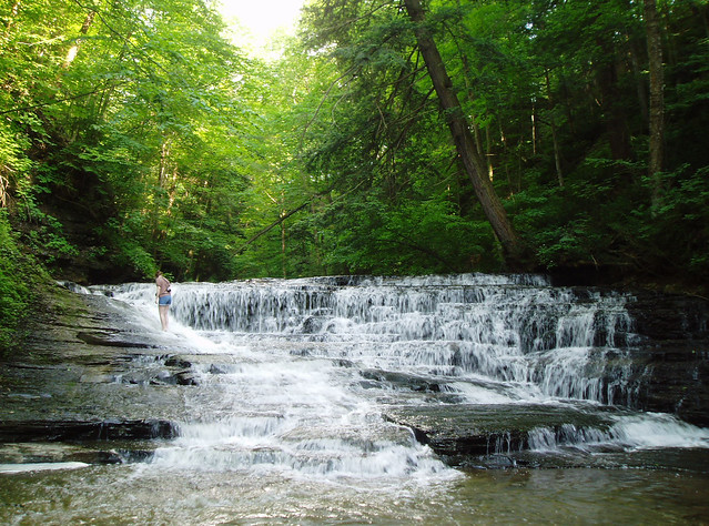
Size/Types: Java Falls, which is visible from the roadside, consists of a 5-6 ft drop, followed by a 3 ft drop. Some broken chunks of limestone tend to gather at the second drop, twisting the creek as it falls. Upstream are some very small ledges that create a run of small rapids.
Up the creek are two more falls within 1/5 mile. One is a chute-like falls with a gradual slope over multiple ledges and the second is Angel Falls, which is listed on USGS maps. Angel Falls is a wide, 30 ft tall cascade surrounded by trees. Both of these upstream falls are on private property.
Best time to visit: Year-round. Avoid dry summer days.
Flow: Moderate
Waterway: Beaver Meadow Creek, which is fed by wetlands 3 miles to the east at Beaver Meadow. It cuts a sizable mile long gorge in the hillside here, leveling out at its confluence with Buffalo Creek just west of NY-78. Buffalo Creek heads northwest to Elma, where it turns west and heads through the south end of the city of Buffalo. It empties into Lake Erie at the Erie Basin Marina and Buffalo Lighthouse.
Time: 10-15 minutes to see Java Falls.
Seasons/Hours: Year-round.
Admission: Free.
Handicap Accessibility: Yes, via roadside view.
Pets: Keep them in the car.
Accommodations: There are some establishments in Java Village, but not much. Hogan’s Deli, which is just up the road, looks pretty good.

Description
Java Falls is often called ‘Angel Falls’ on maps and in some guides. There’s clearly some confusion as to which of the falls here is in fact Angel Falls. Java Falls seems to be a modern moniker for the roadside falls, but not by any official sources. The consensus is that Angel Falls is quite a distance upstream, and that this roadside waterfall, while not officially named, fits well with the ‘Java Falls’ moniker.
Java Falls is not huge. It’s not very photogenic either, at least from the angles afforded by the roadside. There’s no creek-walking, no climbing, and no deep pools to cool off in. It’s an easy waterfall to see in a little hamlet and it’s easy to check off your list.
The two upper falls are in a shaded glen, undeveloped, and much more pleasing to the eye. Angel Falls was at one time accessible. The landowner would allow access through their property. As of 2012, the family asked visitors to no longer walk across their land, rather to only access it from a creek-walk up from Java Falls. We waterfall enthusiasts couldn’t complain about that adventure. Unfortunately, recently the land has been posted and access is by permission only.
History
The town of China was split out from the town of Sheldon in 1818. The town of Java was formed from the town of China in 1832. It was named after the island of Java. The town of China changed to Arcade in 1866.
An excerpt from History of Wyoming County, N.Y., with Illustrations, Biographical Sketches, published in 1880 by F.W. Beers & Co., describes the mill history of this stretch of Beaver Meadow Creek:
HISTORY OF BUSINESS AT JAVA VILLAGE The first grist mill in the town of Java was built at this place in 1816 by Samuel H Wooster. It stood not far from the east bank of Buffalo creek from which the water was conveyed through pump logs to the overshot water wheel. The stones used were chiseled from native rocks and moose wood bark constituted most of the belting and fastenings. Many laughable stories are yet told of the capacity and workings of this mill. It continued to do execution for two or three years when Mr Wooster built another near the site of the present one. It was a square building of hewed logs and the power and machinery were sufficient for the demand for a time. This mill he operated until about 1822 when he sold it to Gourney & Whitney. They were succeeded by Joseph Barber and Charles Richardson. The construction of the present grist mill was begun by Barber & Richardson in 1835 and completed by Mr. Richardson in 1836. Harry Eddy built a saw mill at this place as early as 1820 which he operated several years. It was afterward owned by DW Hall and still later by L Cleft on whose hands it burned down. Lyman D Wood located here about 1825 and soon after built a mill for wool carding and cloth dressing which he carried on many years. The building was converted into a saw mill by Peter G Clark and is now owned and operated by Richardson Howard as a saw mill and cheese box factory.
In the early 1900s an electric rail line was started. The route would link Java Center, Java Village, and Strykersville, with East Aurora. The land was graded for it in Wyoming County, but it seems to have stopped there. A 1912 map shows the line, and some evidence of the grading can be seen on modern satellite imagery.
The 1902 map also shows the town hall on the site of the Java Agency building.

Hiking / Walking Trails
Difficulty: Easy.
Markings: Just road signs and the Java Agency building, which is right next to Java Falls.
Distance: Depends on how far you park down the road. It can be a few dozen feet.
Description: Find a spot on the side of NY-78 and walk to the bridge over Beaver Meadow Creek. Java Falls is right there on the side of the road next to the Java Agency. The falls is on private property, so keep out.
Map: Interactive.

Java Falls Interactive Map
Java Falls (Angel Falls) Media
Videos

Contributor Photos & Art
In 2011, NYFalls Talk message board member, Chris B (cbobcat49) made the creek walk to the real Angel Falls. Here are his photos of that trek:


Interesting Stuff
Java School No. 1
Listed on the National Register of Historic Places in 2001, this white, two-story, frame schoolhouse was constructed around 1950 in the Italian Villa style. It operated as a school until 1967. It now serves as the Java Historical Society Museum. It is open by appointment only. Map
Who to Contact
No contact information
