Hume Falls (Cold Creek Falls)

Location: Hamlet of Hume; town of Hume; Allegany County; New York
Maps: Google Map; Topographic; Interactive map.
GPS: Upper Falls: (N 42.47307 / W 78.13645)
Lower Falls: (N 42.47301 / W 78.13611)
Town of Hume Highway Dept: (N 42.46873 / W 78.12939)
Directions: The hamlet of Hume is just west of the hamlet of Fillmore and south of Letchworth State Park.
From Letchworth/Portageville: Take NY-19A south for 9 miles.
In Fillmore, turn right onto W Main St (NY-19) and follow it for 1 mile.
Look for a garage complex on the left with a sign that says “Town of Hume.”
Turn left into this complex.
From the south: Use I-86 to exit 30 for NY-19 toward Belmont/Wellsville.
Head north on NY-19 for 18 miles to Fillmore.
In Fillmore, turn left onto W Main St (NY-19) and follow it for 1 mile.
Look for a garage complex on the left with a sign that says “Town of Hume.”
Turn left into this complex.
Use Google Maps.
Parking: The best parking spot with access to the creek is through the town’s highway department facility. I’m not 100% sure if parking is allowed, but some have parked here with no issue. It’s best to visit on weekends when the facility is empty and your car won’t get in the way. You should park off to the side and out of the way of anything. Maybe leave a note on your windshield with your cell number on it, just in case.
Weather
Information / Accessibility / Accommodations
Number of falls: 2, separated by 100 ft or so.
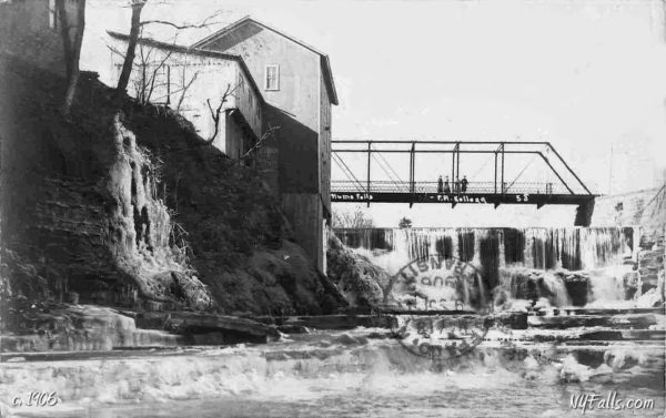
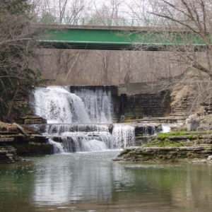
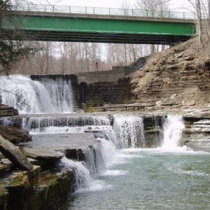
Size/Types: The upper falls drops slightly over the remnants of an old dam with some of the flow dropping straight down. The left side of the falls is less steep and bounces over a protruding rock formation. The upper falls is estimated at 22 ft high. The lower falls is a 5 ft high cascade with an irregular face and a large and deep pool below it.
Best time to visit: Spring through summer. Weekends (because of parking).
Flow: Moderate.
Waterway: Cold Creek, which starts out north in the hills of southern Wyoming County, travels 10 miles southeast through Hume and to the hamlet of Fillmore, where it empties into the Genesee River. The Genesee flows north through Letchworth State Park and Rochester, emptying into Lake Ontario at Ontario Beach Park 60 miles north of here.
Time: An hour.
Seasons/Hours: Daylight hours. Year-round. Best for parking on weekends.
Admission: Free.
Handicap Accessibility: None.
Pets: No rules are posted, but pets need to be on a leash in public.
Accommodations: There are some restaurants and shops in Fillmore to the east.
Description
AKA: Cold Creek Falls.
A beautiful set of falls next to the CR-23 bridge is the highlight of this small hamlet. From the bridge, the falls tumbles 22 ft down an irregular shape, travels downstream across a flat creek bed, only to drop another 5 ft into a deep emerald pool.
Not too far out of the way from Wiscoy Falls, Hume Falls is not as big or popular—being more of a local secret. In summer it’s common to see people swimming in the pool below the falls. While the bridge is right there, the best way for visitors to access it is via a 0.4 mile walk upstream from the highway department complex. Expect to get wet.
History
The Town of Hume, probably named after Scottish philosopher and historian David Hume, was first settled by Roger Mills in 1806. At the time, Hume was a part of the town of Angelica. The first settler in the hamlet was Sylvanus Hammond (from Middlebury) around 1820. The hamlet was originally known as Cold Creek.
The first bridge over Cold Creek was constructed here by George Dennis and George Barker in 1823. It was constructed using large pine logs. The seams were packed with mud and sticks, much like the construction of a log cabin wall.
The first sawmill in the village was erected near the falls in 1823 by Blakely and Doake. The first gristmill was built in 1829 by Ozro Thomas and John Freeman.
On June 9, 1892 a huge flood struck Cold Creek, causing massive damage to the Village of Hume. An account of the flood, as told in the biography of one of its survivors, Augustus Henry, was shared in the book “Allegany County and Its People: A Centennial Memorial History of Allegany County, New York” (published in1896):
Mr. Henry was one of the victims and the only survivor of the most memorable disaster in the history of Hume June 9 1892. A cloudburst in Centerville changed Sixth Town Creek to a torrent and raised Cold Creek to a rushing river. A crowd of people stood on either bank of the mad stream watching its wild plunge over the falls, little dreaming that the terrible current was swiftly cutting the earth from under their feet. Without warning, at 6:30 PM the bank fell, precipitating 5 men into the flood, George Meech and his son Hartley, Elias Craft, A. W. Henry and his brother in law Burdett Ayer. The latter two grasped each other went over the falls together and were not separated till near the whirlpool. Mr. Henry’s arm caught between two rocks crushing his hand and the bones of his right arm. Burdett was hurried down the stream and rescued near Fillmore in an unconscious condition. He died Saturday evening from injuries to his head. After the seething waters had torn Mr. Henry from between the rocks, he was carried several times around the whirlpool and then shot down the stream to an island a hundred rods below where he managed to crawl to a place of safety. A great crowd gathered but it was 4 hours before the stream lowered enough to allow a man to reach the island on a powerful horse, by which means he was rescued. His recovery was painful and slow, and his hand and arm are still crippled.
Hiking / Walking Trails
Difficulty: Moderate to difficult. If the creek level is high, you will need to get wet and either avoid deep pockets or swim.
Markings: None. It’s a creekwalk.
Distance: 4/10 mile one way.
Description: You can see the falls from above on the CR-23 bridge, but just the lower section and it’s almost a straight-down view.
Creekwalk to the base of the falls: Park somewhere out of the way at the town highway department. Visiting on weekends is best so there’s less of a chance of business happening at the facility.
Head down the gravel/dirt utility road toward the gravel piles and river. There should be a dirt path leading down the creek.
Once down there head upstream, which will be to the right. There’s a chance, even if the creek level is low, that you may need to ford it at some point. Be prepared to get wet. Use caution when stepping in the creek as there are some areas that are unexpectedly deep. If water levels are very high, maybe skip this one?
The creek will bend left as you get about 2/10 mile up. Keep going. Around that bend, you will see the falls and the bridge in the distance.
Arrive at the falls and pool at about 0.4 mile.
Retrace your steps to get back.
Map: Interactive.
Hume Falls Interactive Map
Hume Falls Media
Videos

Explore More
Letchworth State Park
Referred to as “The Grand Canyon of the East,” Letchworth is nowhere near as large or interesting as the National Park. But for the region, it is a beautiful giant park, with a dozen or so waterfalls, plenty of trails, and some of the best sights in the northeast. Think you’ve seen it all before? You most likely haven’t. Check out this guide to find all of the waterfalls in the park.
Wiscoy Falls
A beautiful and large roadside falls just east of Mills Mills Falls. Take the small trail up the north side of Wiscoy Creek to see even more falls.
Who to Contact
Town of Hume
585-567-2666


