Fellows Falls, Onondaga County


Location: Tully, Onondaga County, New York
Maps: Google Map; Topographic; Interactive.
GPS Coordinates:
- Fellows Falls: N 42.81576 / W 76.16069
- Large Falls: N 42.81614 / W 76.15778
- Parking: N 42.81573 / W 76.16237
Directions – Located near the south end of Woodmancy Road in Tully. The easiest way to get there is to take NY-5/20 until it intersects with Route 80. Take NY-80 south until you reach the south end of Woodmancy Road. Head north on Woodmancy. It’s a short drive to the two noticeable sets of guardrails on the right side of the road.
Or use Google Maps.
Parking: Scarce. Pull off to the side of Woodmancy Road in the small dirt area near where it crosses over the creek.
Weather
Information / Accessibility / Accommodations
Description
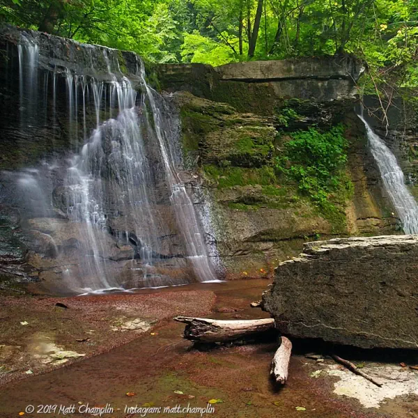
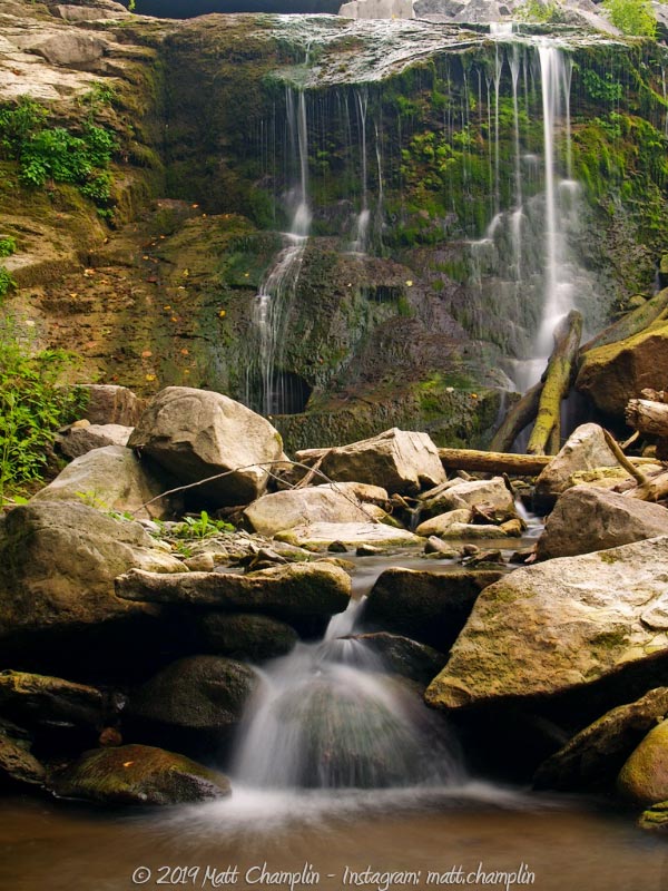
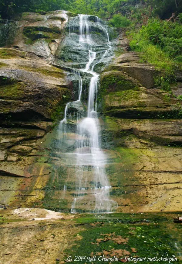
Fellows Falls is just one in a series of ravines and glens that course water down from the Tully Hills, through the valley, and then into the city of Syracuse. We were able to find 4 waterfalls, ranging in size from 10-65 feet in height. Three of them follow the typical shale-makeup of most Finger Lakes region waterfalls, but the main attraction, the 65 foot Fellow Falls, cascades down steep, multi-hued layers of rock, creating a beautiful sight. The material is called ‘Tully Limestone’ and is unique to this portion of New York State. It contains rare fossils not found anywhere else.
The portion of the gully near Woodmancy Road suffered from a landslide about 10 years ago that destroyed part of the road itself and required extensive repair, which unfortunately disrupts the view of the upper falls. It’s also important to note that the mud and clay make-up of the land in this area is very unstable at times of high rainfall. Be careful and check the weather prior to exploring this gully.
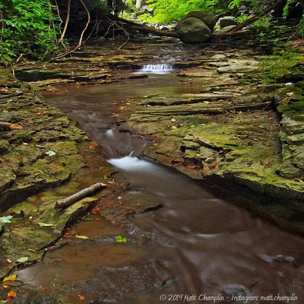
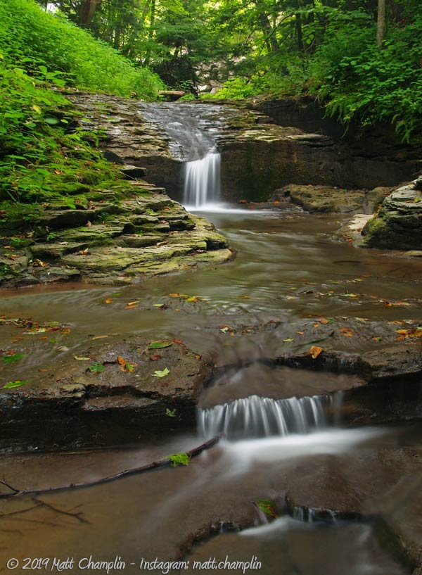
Many people are not even aware of the lower reaches of the ravine that are in a much more natural and beautiful state (compared to the heavily constructed upper falls). The lower gully is surrounded by mature forests which command a beautiful view down into the Tully Valley. There are a few large pools for wading, and since you will be walking downstream, you approach the falls from the top and can enjoy beautiful vistas as you look downstream into the gorge.
History
During the last ice age, the edge of a giant glacier stood at Tully Valley and had built up an enormous end moraine about 600 feet high across the valley. As the torrents of melt water flowed south, they spread quantities of gravel and sand that now make up much of the valley floor. It is the most extensive area of glacial outwash in Central New York. The ravines above the floor of the valley have gradually eroded, forming steep gorges that make up the numerous waterfalls in the area, consisting of both Tully Limestone and shale. Just south of the moraine and Fellows Falls, lie the Tully Lakes, pothole and kettle lakes formed from enormous melt-waterfalls and chunks of ice from the receding glacier.
The area around Onondaga Creek in Tully has always been known for its salt deposits. Native American and early settlers to the region were aware of salt wells at the south end of where Fellows Falls lies. About 380 million years ago, the area below Fellows Falls contained a shallow sea, which condensed to form salt mineral. This area was historically favored for excellent salt deposits. It wasn’t until 1889 that the Solvay Process Company began mining the salt (1300 feet below the surface). Mining continued until the mid-1980’s. The wells were plugged in the late 1990’s when the DEC became concerned about seepage into streams and ground water. For more information about the pollution of the Onondaga watershed, read this.
The area has recently been known for landslides that dropped portions of the clay-based hillsides down into the valley, the biggest being in 1993. This area, as well as the whole Onondaga Creek watershed, are often disturbed by farm run off, gravel mining, and denuding of the hillside for housing developments.

Hiking / Walking Trails
Note: Land surrounding Fellows Falls is posted. Some of the ravine is land that was once owned by Allied Chemical, and more recently, Honeywell International. Unfortunately I haven’t been able to verify if the falls are accessible or not. Most recent reports say that 2 of the falls closest to Woodmancy Rd are, but require a dangerous climb to continue further. Respect land rights and do not trespass onto posted land. Be safe.
Difficulty: Difficult.
Markings: None.
Distance: A half-mile creek-walk to the last of the waterfalls.
There are no well-defined trails. Viewing the roadside falls is easily done from the top of Woodmancy Road. Getting down to the creek bed below is a different story, due to the recent landslide. There are newly built rock retaining walls that provide for a way to scramble down, but it should be done with extreme care.
Once in the ravine, creek walking down some slippery shale will reward you with a much better environment than that closest to the road. There are numerous cascades that you’ll have to carefully scale down to reach the top of the main waterfall. About a quarter of a mile from the road, you will reach the crest of the 65 foot Fellows Falls, which you won’t be able to see to well. To get a decent view, cross the creek and walk to the right where you will see an opening in the woods and a rough game trail. If you carefully follow the wooded ridge that descends to the right of the gorge, you will be rewarded with brief peeks at the falls through the woods. Continue the descent on the ridge and eventually you will reach an area where you can get to the bottom of the ravine and walk right to the base of the falls. To view the final waterfall, continue downstream a short distance and walk on the hill to the right of the gorge. This will take you to the bottom of the fourth waterfall.
Map: Interactive.
Fellows Falls Interactive Map
Fellows Falls Media

Interesting Stuff
Glacial pool lakes
Green Lake Beach is located to the south and is an excellent location to view kettle lakes, formed by melting chunks of glacial ice as well as lakes formed by the plunge pools of massive waterfalls that streamed down the melting glacier. Check out Green Lakes State Park for more information on these types of formations in Central New York.
Photography Tips
Capturing the falls
- The upper falls does not provide much in the way of nice shooting during the hot summer months. It is in the open, water is coming from a culvert, and the flow is very low. Early spring or fall, when rainfall is more ample, are the best times to photograph the upper waterfall. Attempt to position your camera so you don’t capture the area where the landslide was, as it detracts from the scene.
- The lower waterfalls in the gully are much nicer, surrounded by trees and mosses. It is narrower here, and the falls look good, even in low flow.
- Try shooting from the top of Fellows Falls, looking down the ravine into the Tully Valley.
- To capture the Fellows Falls, you must reach the bottom of it. You’ll need a wide-angle lens and a polarizer. Portrait shots works best. The moss at the base of the falls adds nice contrast to the picture.
Overcast skies
- Daylight will cast uneven shadows through the canopy and cause sunspots in your shots. It is best to wait for an overcast sky for this one.
Getting wet
- Be sure to carry your camera in a waterproof pack. You’ll have to tread through water.
Silky Water Effect
- To get that smooth cotton-candy look to the falls, you need to use a Neutral Density (ND) filter on your lens. The ND filter will block some of the light from entering the lens without altering the color, and thus allow your shutter to stay open longer. This blurs the water and creates a soft white gloss to the foamy areas of the falls. Check out the article for the all the details.
More tips
- See the Articles for more photography tips.

Who to Contact
None.