Holley Canal Falls


Location: West of Rochester; in Falls Park; in the village of Holley, Town of Murray, Orleans County, New York.
Maps: Google Map; Topographic; Interactive map;
GPS Coordinates:
- Parking: (N 43.22550 / W 78.01931)
- Holley Canal Falls: (N 43.22503 / W 78.01835)
- Canal waste weir: (N 43.22503 / W 78.01835)
Directions: From Rochester…
- Take I-490 west to Rt 531 and follow that for 8 miles until it ends in Brockport.
- Continue on NY-31 west for 6 miles and follow it as it turns north, then west, then north again leading into the village of Holley.
- Turn right onto Frisbee Terrace and follow it to the end, staying to the right. It will head down into a wooded area where you will see the falls.
From Buffalo…
- Take I-90 east to Batavia.
- Turn North onto NY-98 and follow it to NY-31 in Albion.
- Turn right (east) and follow NY-31 to the village of Holley.
- Turn right onto Frisbee Terrace and follow it to the end, staying to the right.
Or use Google Mapss.
Parking: Park directly across from the falls in the lot at the end of Frisbee Terrace. You can also park in the lot off of East Ave near Perry St and walk from Canal Park south to the glen.

Weather
Information / Accessibility / Accommodations
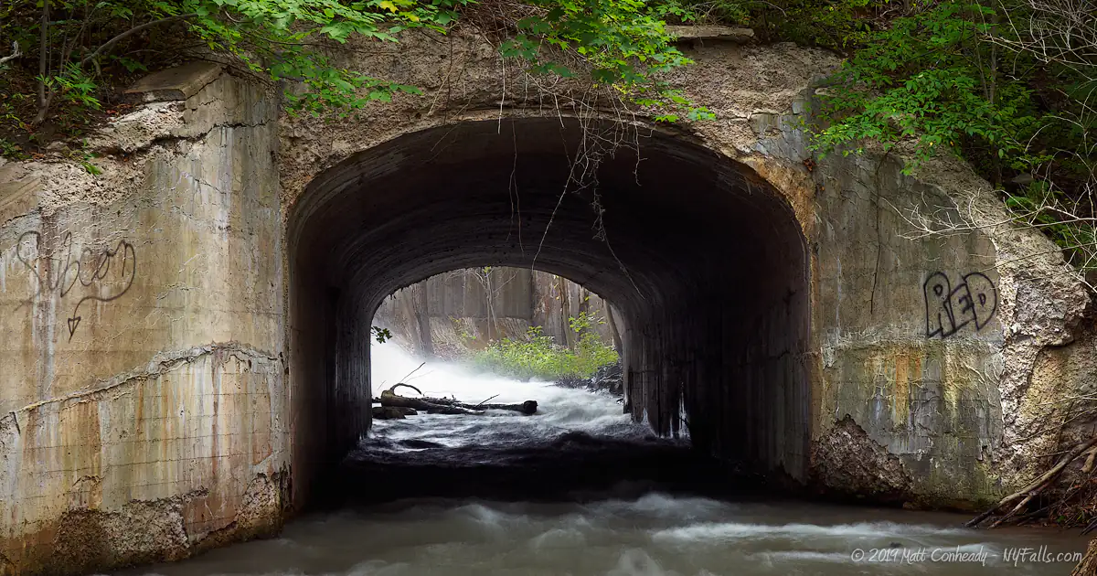
Number of falls: 1 major waterfall, a few small drops upstream, and then the waste weir of the canal, which is more plumbing than waterfall.
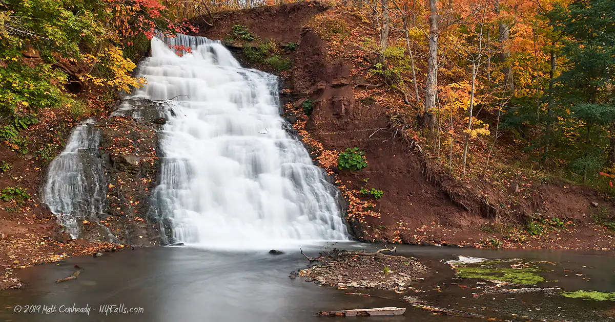
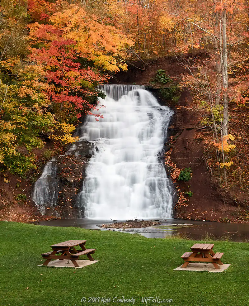
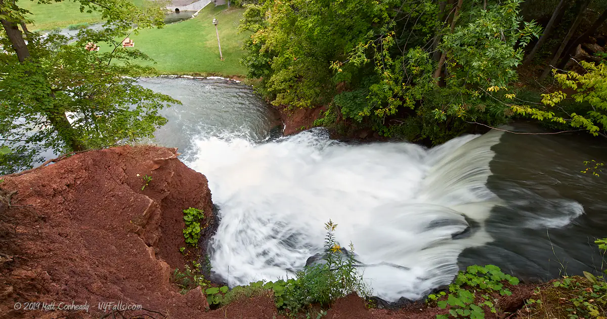
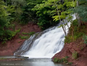
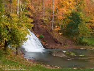
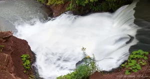
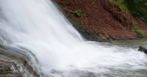
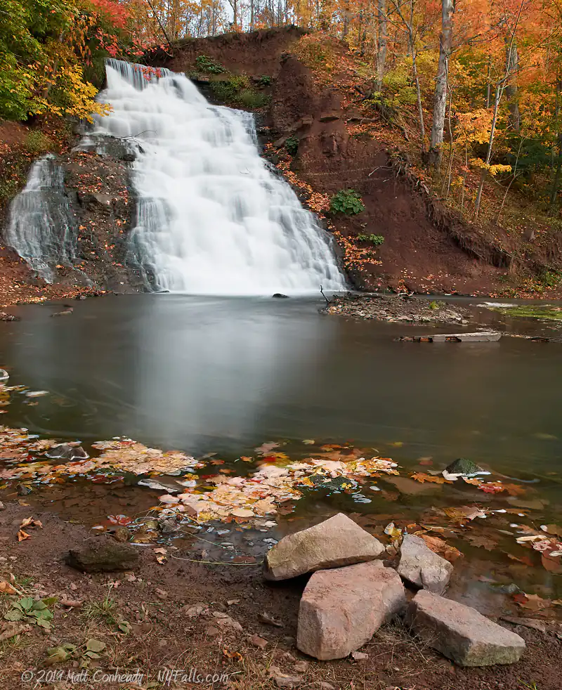
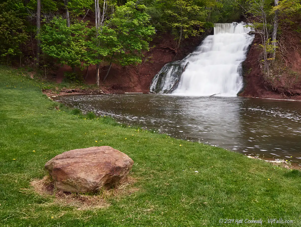
Size/Types: Holley Canal Falls is a man-made, 35 ft cascade over red medina sandstone and surrounded on each side by lush wooded landscape. Just above it is a split in the waterway that yields a few small drops. The waste weir of the canal is about a 5-10 ft drop from a pipe into the waterway that feeds the falls.
Best time to visit: Spring through fall. When the canal is drained, the falls stop flowing. The canal runs from April through mid-November, although these dates may change. In 2024 the canal was set to open in May.
Flow: Constant heavy flow from April to Mid- November.
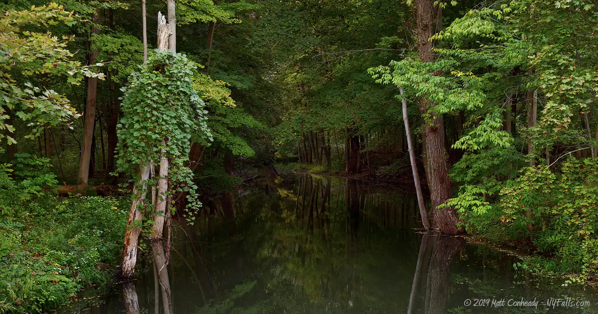
Waterway: Overflow water from the Erie Canal, which empties into the East Branch of Sandy Creek, and eventually makes its way to Lake Ontario east of Hamlin Beach State Park.
Time: Anywhere from 10 minutes to one hour (if you were to hike a loop to Canal Park and back).
Seasons/Hours: Open year-round, from sunrise until 10pm.
Admission: Free.
Handicap accessibility: Yes, the waterfall is completely visible from the parking area, and the canal-side trail is paved.
Pets: Allowed if on a leash. For your pet’s safety, and the safety of other hikers, keep your pet on the leash! It doesn’t matter if your dog is “friendly,” it’s the law. Please clean up after.
Swimming: The pool is deep enough to wade in, but there’s a sewage discharge right there. Don’t swim in the canal either.
Accommodations: There are restrooms located in the canal park, but they are designated for boaters. If you really need to use them, ask the East Ave bridge attendant; historical markers; trails; fishing; picnic tables; grills; pavilion; boat dock (at the Canal Park).
Description
AKA: Holley Falls; Canal Falls; Glen Falls; Holley’s Glen Falls
The land just south of Lake Ontario in Western New York is relatively flat, with dirt and clay glacial drumlins creating most of the relief. Waterfalls in this basin, that traverse large rock escarpments, such as Holley, Waterport and Wolcott Falls, are rarities. The glen that contains Holley Falls, was actually carved out long ago by Sandy Creek as it cut along a north-south ridge east of present-day Holley. The natural waterfall that most-likely led the excavation of the glen has since receded over a mile south to the crossing at S Holley Road, where a dam taps it for power-generation. Although the glen’s origins predate history, Holley Canal Falls’ beginnings can be traced back to about 1918, with the construction of the Barge Canal.
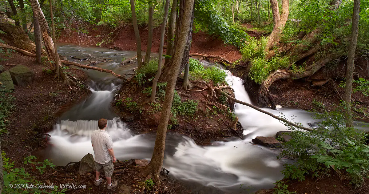
As one enters Glen Park, the scene is striking. Out of a densely wooded hillside, a large frothy cascade tumbles down reddish rock and into a shallow pool, which then meanders around a small park and joins a passing creek. The creek then seems to disappear below that very same hillside to the north. This picturesque setting is actually the result of a marvel of engineering, of which the waterfall is just a side-effect. Holley Falls is, in fact, man-made—the unintended result of excess water emptying from the Erie Canal. Water empties from the canal through an adjustable weir just up the embankment and tumbles down several drops as it works its way through the tree-covered hilltop. Here it even splits in two briefly only to rejoin before it drops 35 feet over the escarpment creating Holley Falls.
The red rock and soil that create such a striking view (especially against the fresh green foliage of spring) is the result of Medina Sandstone, which contains high amounts of oxidized iron (rust). Occasionally, sudden bouts of high rain will wash large quantities of the red soil into the falls, briefly turning the waters pink, but for the most part the falls is a frothy white, leaving a trail of suds that swirl in the waters underneath. The canal’s water-flow joins Sandy Creek just 20 yards from the falls, and it then exits the glen underneath a man-made section of the canal’s embankment.
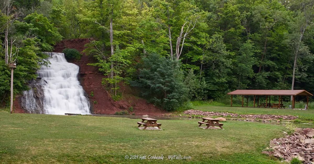
A few benches, picnic tables and a covered pavilion are great ways to enjoy the sights and sounds of the falls with friends and family, and a series of well-maintained trails take you up the embankment for better views of the canal and the falls from the top. A few offshoots will get you to the rushing waters just above the falls, and with a bit of shuffling upstream, you can see the waste weir clearly. Trails also connect the glen with the Canal Park on the waterfront to the northwest, making this an excellent picnicking and hiking outing.
History
Although the town of Murray was first settled around 1809, it wasn’t until after the completion of the Erie Canal in 1825 that the community of Holley began to take hold. Originally a sparse settlement called Saltport, named for the salt springs discovered along Sandy Creek, the settlers would collect brine, boil away the water, and then use the salt to preserve meat and produce. The proximity of Holley to the cool, moist air of Lake Ontario blessed it with excellent conditions for fruit orchards, from which it would prosper once the canal allowed for better distribution of the goods.
As the canal was surveyed and construction took place on the massive abutment over Sandy Creek, workers camped in Saltport, boosting the economy and demonstrating the potential that the canal had as an economic catalyst. Some workers even stayed to settle in the area. This abrupt and unexpected success of the canal was obviously exciting to the early residents of Saltport, who renamed the settlement “Holleyville,” after Canal Commissioner Myron Holley. It was incorporated in 1850 as the Village of Holley. The principal industry in Holley, from the onset of the canal up through today, is agriculture with an emphasis on fruit orchards, evident with the large number of fruit stands and farm markets peddling fresh apples and cherries.
It wasn’t until the Barge Canal system, a significant upgrade to the Erie Canal, was completed in 1918 that Holley Falls was formed. One particular upgrade to the old Erie Canal was a drainage system that handled overflow and allowed for the canal to be drained in winter. This system was key in preventing flooding and freezing damage to the canal and its surroundings. A waste weir was installed in Holley, and water poured out and down the escarpment below and into Sandy Creek. It probably took several years for the water to erode away the soil and plant life and the falls to take shape. During this time the land that is now the park was wild and wooded. In 1985 the village began to clear the grounds, revealing the hidden falls to the public. In the late 90s the State of New York began a campaign to assist canal-side communities in developing the canal as parks and entertainment districts. Holley was awarded a grant under this program and began work developing the glen and canal parks as well as a network of trails.
Hiking / Walking Trails
Should you go in the water? Well, It’s water from the canal, then there’s a wastewater treatment outlet where the canal water meets the creek. Yeah it’s a little downstream from the falls, but it’s right there. I wouldn’t recommend it.
Difficulty: Easy.
Distance: Less than a mile, to get to the falls, nearly two miles to loop to Canal Park and back.
Markings: Wide dirt, gravel and paved pathways.
Description: From the parking area, head left towards the wooded embankment and follow the gravel path to the small grassy area in front of the falls. There are a few dirt trails that lead right up the embankment. It’s up to you if you want to take the tough climb up. An easier way is to head back to the parking area and then cross the bridge over Sandy Creek towards the pavilion.
Just before the pavilion, the trail shoots off into the wooded area to the right. At the fork, go left. Going right will lead you to an open field. The trail will have a moderate incline at this point as it leads up the scarp. Near the top, you should be able to hear the falls and follow the small offshoot to the crest.
Continue up the trail which then crosses over the weir’s waters, to make it to the Canal Trail, which is wide and paved. If you lean over the railing here, you can catch a glimpse of the waste weir. Where the first picnic table is, you can shuffle down the embankment a bit to see the small drops and the crest of Holley Falls.
You have several options for getting back. If you are in the woods above the falls, steep trails will take you down the hillside and put you in the grassy area next to the falls. The Canal Trail, heading north-west will get you to Canal Park, and a looping trail that leads back to the parking area at Glen Park. Or just turn around and head back the way you came.
Map: Interactive.
Holley Falls Park Interactive Map
Holley Canal Falls Media


Interesting Stuff
The Murray-Holley Historical Society
A 1907 train depot is restored and houses local historical displays, artifacts and genealogies. Located near the park on Geddes St Ext. By appointment.
Wastewater
The quality of the water here is in question. Think about it before you get wet. Although Sandy Creek is a natural waterway, the Holley Falls is waste-water from the canal. Just downstream from where the canal water joins the creek is where the village’s wastewater (from the treatment plant up the road) empties into the Creek as well. The large stones are there to discourage upstream mixing of the municipal wastewater with the waterfall’s pool.
Bird-watching
At dusk, cedar waxwings like to fly just over the rocks at the intersection of the canal water and the stream. From the benches you can watch their aerial acrobatics as they dash back and forth catching insects mid-air.
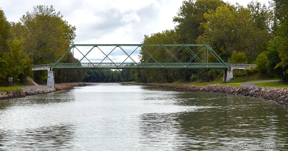
Canal Park
The trail to canal park is an enjoyable walk that leads to a recently developed mini-port on the canal. The park features a gazebo, picnic tables, grills, and campsites, restrooms and showers for passing boaters. The bridge that takes East Ave over the canal lifts to allow boat traffic to pass.

Photography Tips
Foreground
- Don’t just zoom into the falls, there’s plenty to work into the foreground of your shots, including the stream, picnic tables and the large orange boulder.
The creek
- Don’t just concentrate on the waterfalls, there are plenty of small drops, twists in the creek, interesting stones and trees along the way.
From the top
- Take the trail up to the top of the falls. There’s an opening in the woods near the crest for top-down views.
Silky Water Effect
- To get that smooth cotton-candy look to the falls, you need to use a Neutral Density (ND) filter on your lens. The ND filter will block some of the light from entering the lens without altering the color, and thus allow your shutter to stay open longer. This blurs the water and creates a soft white gloss to the foamy areas of the falls. Check out the article for the all the details.
More tips
- See the Articles for more photography tips.
Who to Contact
The park
Village Of Holley
72 Public Square
Holley, NY 14470
Phone: (585) 638-6367
villageofholley.org
Canal Tourism Information, Canal Conditions, Canalway Trail
NYS Canal Corporation
Phone: 1 (800)-422-6254
canals.ny.gov


