Stuyvesant Falls


Location: In the hamlet of Stuyvesant Falls; Town of Stuyvesant; Columbia County; New York.
Maps: Google Map; Topographic; Interactive map.
GPS Coordinates:
- Upper Stuyvesant Falls: N 42.35913 / W 73.73118
- Lower Stuyvesant Falls: N 42.35690 / W 73.73399
- Hudson Ave Bridge: N 42.35721 / W 73.73334
Directions: Take US-9 to Stuyvesant Falls and turn onto New Street. Follow New Street past a few houses.
It turns a corner and becomes Woods Ln. Pass an old factory building on the right and the road will veer right onto a steel bridge. This is 25A/Hudson Ave. Just after the bridge, turn left onto Lindenwald Ave. Immediately after that turn is the entrance to Stuyvesant Falls Park.
Parking: Stuyvesant Falls Park has a lot with room for about 30 cars. Drive into the park entrance and follow the dirt road to the lot at the end.
Weather
Information / Accessibility / Accommodations
Number of falls: 2 waterfalls visible (1 partially) along Kinderhook Creek. In high flow, there are a handful of smaller falls in the gully directly south of the crest of lower falls, parallel to Hudson Ave and Hotel Lane. These are not visible or accessible.
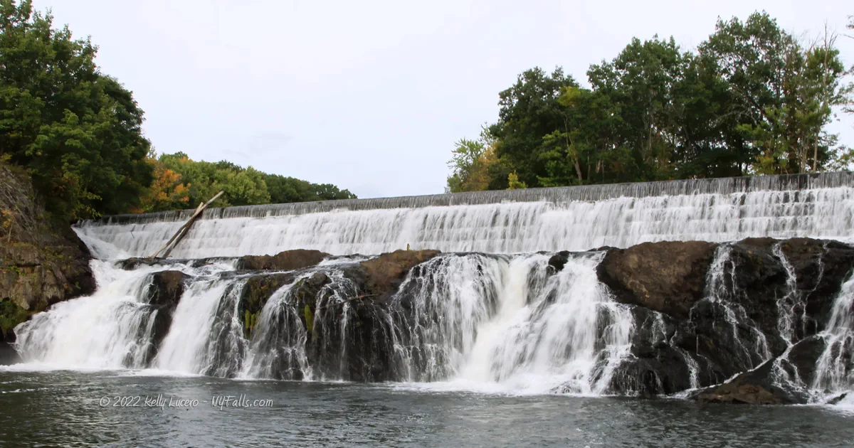
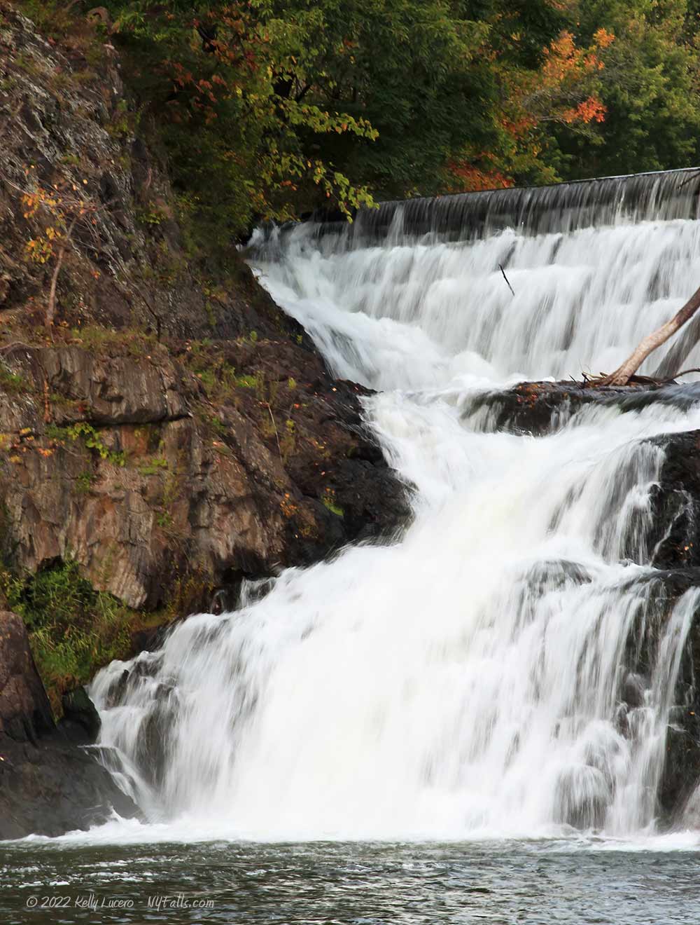
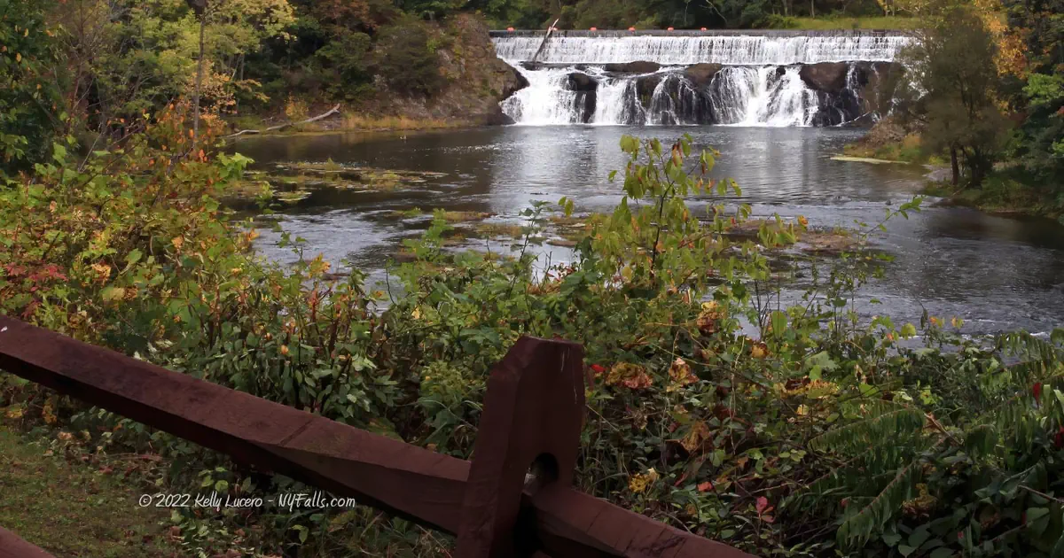
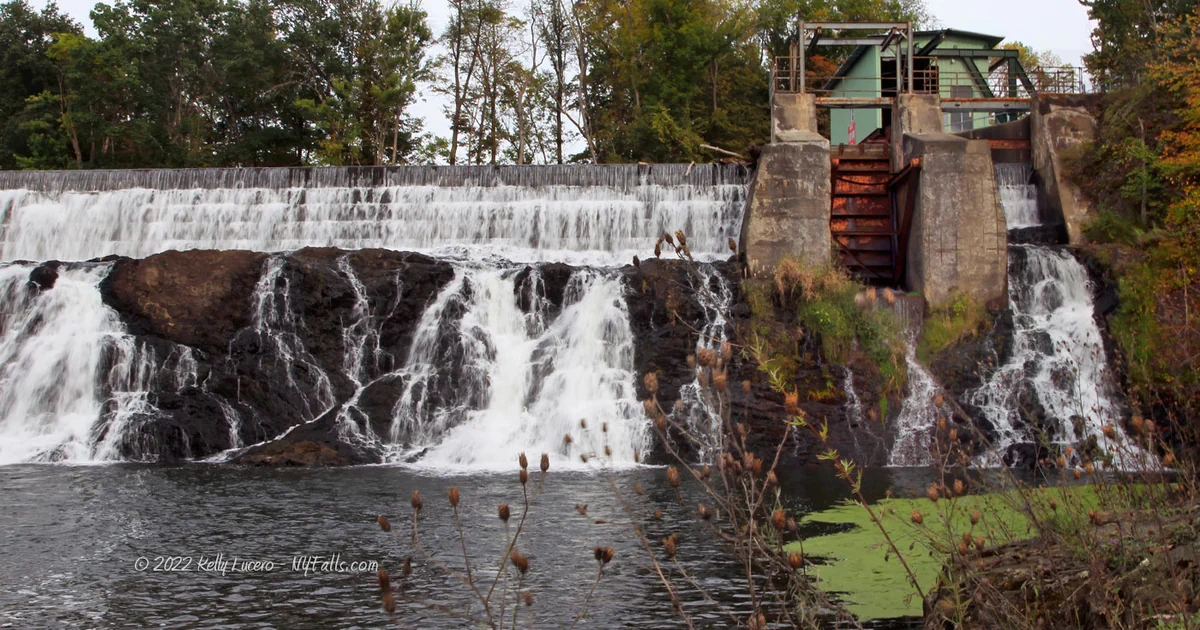
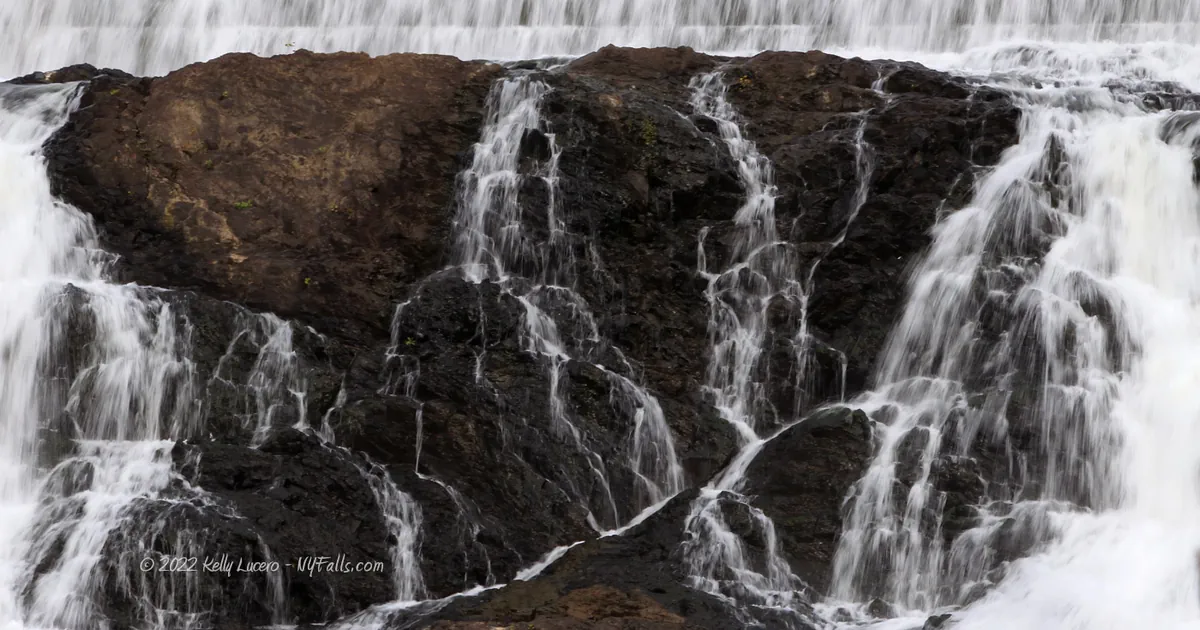
Size/Types: The upper falls (which is visible from the park) is a 220 ft long cascade over tall and uneven bedrock. About 26 ft high, the top 6ft or so is a man-made concrete dam that holds water back for the small powerhouse on the south flank. The dam isn’t a single slab of filled concrete, rather it’s formed by bricks. Water cascades down the 6 striations of bricks on the dam, filling the area with the pleasing sound of rushing water.
The lower falls, which can be seen from the Hudson Ave bridge, is about the same height with a more uneven face, some of which is rounded overhangs. This odd shape often splits the creek into two channels that plunge into the gorge below. It’s not possible to get a good view of it. It is 45 ft high.
Best time to visit: Year-round.
Flow: Moderate. It’s usually flowing, although the falls may not be fully covered in dry late summers.
Waterway: Kinderhook Creek, which has a total length of 49 miles. It starts 25 miles northeast in Hancock, Massachusetts in the Hancock State Wildlife Management Area. It meanders west into New York, passing through many small towns it helped power throughout the years. After Stuyvesant Falls, it heads south for 2.5 miles where it merges with Claverack Creek into Stockport Creek in Stockport, NY. Stockport Creek heads west for 1.5 miles, emptying into the Hudson River at the Stockport Flats Estuarine Sanctuary. The Hudson River flows south to the Atlantic Ocean at New York City.
Time: 15 minutes.
Seasons/Hours: Daylight hours.
Admission: Free.
Handicap Accessibility: It’s not recommended. There are no paved pathways. The bridge is steel and not constructed for wheelchair accessibility.
Pets: No rules are posted, but pets need to be on a leash in public.
Accommodations: The park is pretty basic and does not offer much beyond views. If you need food or a rest stop head north on US-9 to Kinderhook and Valatie.
Description
Stuyvesant Falls is a set of two sizable waterfalls on Kinderhook Creek in the hamlet of Stuyvesant Falls, north of Hudson. The Upper Falls and the man-made dam that caps it have excellent views from both sides of the creek. A small town park on the south end is the easiest spot to view it from, allowing you to get right up to the creek bank for an unobscured sight. The falls is wide at just over 200ft and has changed drastically from its natural state to the era of manufacturing mills and once again as it transitioned to hydroelectric power. Water from the retaining pool above the upper falls is channeled underground to the power plant at the base of the lower falls. You can see old foundations and even a sluiceway surrounding the falls.
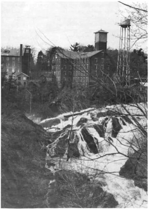
Once over the falls, the creek passes over uneven bedrock, creating a thousand feet of rapids in high flow. The creek passes under an iron truss bridge (constructed in 1899) just before tumbling over the lower falls. While the top of the lower falls can be easily seen from the bridge, full views of the falls from downstream are unfortunately not possible for the public. An old mill building on Woods Lane must have a nice line of sight to the falls, but it’s a private business and off limits. Albany Engineering Corp, which has rehabilitated and operates the hydro-power facilities at the falls has a photo of it on their website.
Just before the lower falls, the creek splits and a small branch heads directly south, creating a small island below the falls. Within the steep gorge in this branch there are several chute-like falls, which tumble down to the the modern hydroelectric plant below. These falls can’t be seen and this section of the creek is not accessible.
The steel truss bridge was constructed in 1899, replacing a wooden one. It was reconstructed in 2000.
Stuyvesant Falls History
The settlement was originally named Glencadia before being renamed Stuyvesant Falls (sometime after 1848). Prior to 1667 the cataracts here were known as Major Abram’s (Straats) Kill after one of the first Dutch settlers in new colonies. The falls were then referred to (in the 1820s) as 2nd Falls (lower falls) and 3rd Falls (upper falls). In this context, the 1st Falls was the falls downstream at Rossman, NY.
Accounts of the falls in its natural state (prior to the dam) is that it was “Horseshoe Fall of Niagara in Miniature” (Edward Augustus Collier · 1914).
There are accounts of a saw mill being first constructed at the falls as early as 1680, but there are not concrete records of this. While settlements began in the greater area after 1650, records of settlers in this immediate area begin in 1765. The town was named after Peter Stuyvesant, the Dutch Director-General of the colony of New Netherland. Many landmarks in the greater NYC area are named after him.
Around 1800 William Van Hoesen constructed a cotton mill and clothing shop at the foot of the island below the lower falls. A dam was constructed on the small rocky channel that runs south from the top of the lower falls. The business prospered producing fine cotton products using hand looms, then powered looms as soon as they were available. The business grew, the shop moved north to the crest of the falls, and his sons eventually took it over. The business was eventually purchased by A.T. Stewart & Co. of New York, who ran it until 1874. The building was sold to the Albany & Hudson Railway and Power Company, with intent to turn it into a hydro-elctric plant for powering rail cars, which it did in 1901.
In 1801 Pitkin & Edmonds built the first paper mill in the region. It was, for a time, thought to be the first in the country, but it was beat by over 100 years by William Rittenhouse of Germantown, Pennsylvania. A grist mill at the upper falls was converted to mill pulp. It operated until 1806 when it relocated downstream to the falls at Rossman, NY.
The lower falls was briefly home to saw, grist, and plaster mills on the east side of lower falls prior to 1873, owned by Martin Van Alstyne and Jacob Rossman. Coventry & Mandeville constructed a paper mill alongside those mills. It operated until 1863 and then it burned to the ground.
A. A. Van Alen dammed the upper falls to power the first of his cotton mills, erected on the east side below the falls in 1827. Another cotton mill was built around the same time on the crest of the lower falls by James and John Waddell. A. A. Van Alen built a large brick factory adjacent to the stone Waddell mill. A third mill was constructed by the venture in the adjacent lot in 1845. The complex manufactured print cloth and at one time had 400 looms producing 100,000 yards per week. This complex on Woods Lane is now home to Allied Healthcare Products.
The park near the upper falls, which was dedicated in 1976, is the site of the first Alen mill and cotton factory.
Hotel Lane is named for being the location of the first inn and tavern, built and operated by Peter Acker, then replaced in 1976 by a larger hotel by William Cullen, at the corner of Hotel Lane and Hudson Ave. It’s now a private residence.
Note that some maps and documents have “Alen” spelled as “Allen.”
The steel truss bridge was erected in 1899 and renovated in 2000
The hydro station here first supplied electricity to the region 1901.


Hiking / Walking Trails
Difficulty: Easy.
Markings: Roads.
Distance: A few hundred feet. Maybe 2,000 feet to get an alternate view of the falls.
Description: From the parking area at the Park, you should see the creek to the north, walk towards it and the Upper Falls will be to your right.
Backtrack out of the park road towards Lindenwald Ave and head 100 ft west to Hudson Ave. Turn right and head onto the steel bridge. Downstream is the crest of the lower falls. Unfortunately this is the best view you can get of it.
For an alternate view of the upper falls, continue crossing the bridge and head right at the fork in the road. You can get a decent view of the upper falls through a break in the trees on your right as you approach Frisbee Lane. This road is named after Henry D. Frisbee, town clerk from 1896-1899.
Map: Interactive.
Stuyvesant Falls Interactive Map
Stuyvesant Falls Media

Video by Kelly Lucero
Contributor Photos & Art
Photo of the lower falls taken in the 1990s by NYFalls community member L_G_D.

Who to Contact
Town of Stuyvesant
(518) 758-6248
stuyvesantny.us