Rensselaerville Falls


Location: About 27 mi SW of Albany; in the hamlet of Rensselaerville; Town of Rensselaerville; Albany County; New York.
Maps: Google Map; Topographic; Trail Map (PDF); Interactive map.
GPS Coordinates: Rensselaerville Falls: N 42.51489 / W 74.14369
Parking area: N 42.51531 / W 74.14043
Directions: From Albany: Take I‑87 to exit 1S then NY 85W for 26 miles.
Turn left on NY 143 (Delaware Tpk) for 2.8 mi into Rensselaerville.
Just before the stone bridge over Tenmile Creek, turn right at the small white “E. N. Huyck Preserve” sign in front of the white house and follow the gravel lane to the kiosk.
Address: 5053 Co Rd 353, Rensselaerville, New York. Use Google Maps for precise directions.
Parking: Just beyond the entrance is a gravel lot capable of holding 20+ cars.
Weather
Information / Accessibility / Accommodations
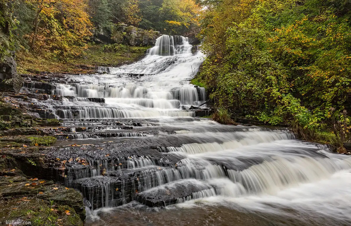
Number of falls: 1 major waterfall with three tiers. 1 man-made dam around the bend above it.
Size/Types: Rensselaerville Falls is about 120 ft total height. The upper 55 ft is the steepest, forming a horsetail shape as it falls from a thick dolomite ledge. The middle 30 ft is a sliding cascade. The lower 35 ft becomes a staircase cascade, but often looks more like a gradual slide in high flow. The entirety of the falls stretches over 400 ft down the gorge, making it look misleadingly smaller than it actually is.
Best time to visit: April–June snowmelt or after heavy summer rain; colorful foliage in October.
Flow: Moderate year‑round, with high flow in March through April.
Waterway: Tenmile Creek, which starts just up the hill at Lake Myosotis (a man-made reservoir). The creek turns south at Rensselaerville and flows straight to Greene County where it joins Catskill Creek. Castkill Creek flows southwest, meeting Cauterskill Creek at the village of Catskill, and then into the Hudson River. The Hudson flows south, through NYC and into the Atlantic Ocean.
Time: From the parking area it’s only a short walk to see the falls, making this a potentially very quick stop. There are 5 miles of hiking trails and two small gullies to explore, so the park can easily occupy several hours.
Seasons/Hours: Open all year from dawn until dusk.
Admission: Free.
Handicap Accessibility: Trails and most facilities in the preserve are not accessible.
Pets: Allowed on a leash.
Swimming: There is a swimming beach on the east side of Lake Myosotis. Beach passes are required and are available to Huyck Preserve members only (membership and pass end up costing over $100 in total).
Boat Launch: A hand craft launch can be found just north of the beach on the east side of Lake Myosotis. While the beach is only for preserve members, the launch seems to be open to the public, but the canoe racks are not.
Accommodations/Attractions: Preserve office; Hiking trails; Swimming (preserve members only); Picnic tables (near the beach); birdwatching; Cross-country skiing; Snowshoeing (rentals available at the visitors’ center). Restrooms and eateries can be found in the neighboring hamlet, at Kuhar Family Farm.
The preserve has three homes/cottages available for rental for corporate or educational events or overnight accommodations. Additionally, the Eldridge Research Station, which is equipped with some scientific equipment, is also available for rental. More info.
Description
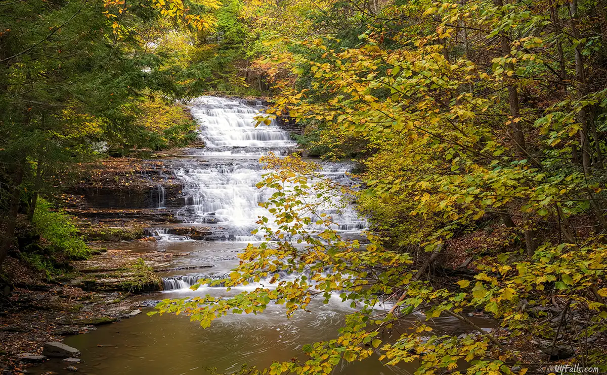
Tenmile Creek leaves the concrete spillway of man‑made Lake Myosotis a large former mill pond, and loses about 120 feet in three stages. First comes a tall, ribbon‑like horsetail that pours straight off the dam breast, followed by a twisting, S‑shaped chute that channels the current between mossy sandstone walls. The water then widens into a graceful sheet that glides over thin shale ledges before slipping beneath the lower footbridge. Because the lake regulates outflow, the falls keep a lively volume in most seasons—an inviting subject for photographers who want silky water without waiting for spring melt. The curving shape of the falls as it emerges from the surrounding woodland creates one of the most picturesque scenes in the region. Best of all, it’s an easy and short hike from the parking area.
Reaching the falls is straightforward: the red‑blazed Falls Trail is a 0.6‑mile round‑trip footpath with crushed‑stone tread, boardwalks, and modest grades of under ten percent. Handrails, two sturdy bridges, and clear signage make it comfortable for families and casual hikers, yet three separate overlooks still give varied angles on the plunges and the moss‑clad ruins of an 1870 felt‑mill foundation, a hint of the past life of the creek prior to its preservation.
Beyond the gorge, the 2,000‑acre Edmund Niles Huyck Preserve protects hardwood ridges, old‑growth hemlock stands, beaver meadows around Lincoln Pond, and spruce plantations planted in the 1930s. More than 12 miles of well‑maintained trails include the easy Lake Trail that loops through ferny wetlands and pine groves around Lake Myosotis, where members can paddle canoes or kayaks, cast for bass and perch, or swim at a small guarded beach in summer. Wildlife watchers scan for beavers, great blue herons, and bald eagles over the water, while researchers at the on‑site biological station track decades‑long studies of forest succession, amphibians, and water quality.
History
Long before the hamlet existed, Mohican and other Algonquian peoples crossed the Helderberg hill country along seasonal paths, likely fishing Ten Mile Creek and gathering hemlock bark for trade. In 1629 the land was folded into the vast Manor of Rensselaerswyck when Dutch merchant Kilian van Rensselaer secured the land on both sides of the Hudson. More than a century later Stephen van Rensselaer III began marketing 160‑acre leaseholds here, tempting post‑Revolution veterans with seven years’ rent‑free farming on what he promoted as fertile upland. By 1787, a scattering of pioneer cabins stood among the woodland hills, and by 1792 settlers were worshipping in a log meeting‑house on nearby Kropp’s Hill. Those “incomplete sales,” which required perpetual tribute of wheat, fat fowls, and a day’s labor, later fed the Anti‑Rent Rebellion that rocked upstate New York for fifty years.
Water was the young community’s engine. Between 1790 and 1830 Ten Mile Creek powered an echelon of grist, saw, fulling, and tannery works that lined the gorge; stands of hemlock supplied bark for leather, while surrounding farms shipped flour and wool to landings at the Hudson River. Reservoir dams—precursors of today’s Lake Myosotis and Lincoln Pond—were finished around 1800 to guarantee year‑round flow for the mills.
Industry peaked when Albany merchant Francis Conkling Huyck and partner Henry Waterbury opened one of North America’s earliest papermaking‑felt factories at the foot of the falls in 1870. Their stone mill turned quiet Rensselaerville into a boom village, but repeated floods—including a devastating one in 1878—splintered the dams and forced the operation to relocate to Albany. The exodus halved the local population, leaving moss‑covered foundations that hikers still pass today.
Francis’s son, Edmund Niles “Ted” Huyck, inherited the property and used it as a summer retreat. When he died in 1930, his widow Jessie Van Antwerp Huyck honored his wish that “the pond and its shores be enjoyed by the people” by deeding 500 acres as the non‑profit Edmund Niles Huyck Preserve in 1931. Its charter pledged to safeguard Rensselaerville Falls, Lake Myosotis, and Lincoln Pond “in their natural beauty” and to foster public appreciation of nature.

Scientific inquiry soon followed. Cornell mammologist, W. J. Hamilton Jr., surveyed the property in 1937 and, the next year, launched one of the nation’s first independent field stations here. Early fellows included ecologist Eugene Odum, later called the “father of ecosystem science,” and zoologist Donald Griffin, whose bat studies unlocked the mystery of echolocation. Continuous research, summer education, and community hikes have run ever since, while strategic purchases and gifts have expanded the Preserve to more than 2,000 acres.
Hiking / Walking Trails
Difficulty: Easy‑moderate (short climbs, some slick roots).
Markings: Trails in the preserve are marked Yellow and Red. On the map they have various colors that are not represented with blazes:
Yellow (Falls Trail), Green (Upper Falls Trail), Orange (Middle Falls Trail). It’s best to have the map loaded on your phone and reference it. Junctions also have signs.
Distance: 0.5 mile one‑way to all three overlooks. There are over 12 miles of trails along various loops in the preserve. Check the map below and explore a bit more while you are there.
How to get to Rensselaerville Falls
Trailhead → Lower Bridge (0.1 mile)
From the parking area behind the white Mill House, head towards the trail and kiosk. Follow the red/yellow-blazed Falls Trail along creekside flats to a narrow wooden footbridge with a head‑on view of the lower cascade.
Lower Bridge → Middle Overlook (+0.05 mile)
Cross the bridge; on this side you will find the ruins to the felt mill that was once powered by the falls. At the junction, left goes downstream, but there’s not much to see there, so turn right and climb the Middle Falls Trail to a rocky balcony that frames the twisting upper two‑thirds of the falls.
Middle Overlook → Upper Falls (+0.15 mi)
Return down to the bridge and continue straight (opposite the bridge) on Upper Falls Trail. A steady climb around a hill will eventually lead to a boardwalk. Eventually you will reach a junction with the Lake Trail West. Go right, cross a second bridge over the Tenmile Creek, and into an area by a small dam. Hook around right, down a few steps, and you’ll be at a wooden viewing platform at the top of the falls.
Return to the parking area (0.25 mi)
Retrace the Upper Falls Trail down to the lower bridge, cross it and follow that trail back to the parking lot.
Maps: Interactive; Trail Map (PDF).

Huyck Preserve Interactive Map

The Huyck Preserve and Biological Research Station has created this digital map that works with your device’s GPS. It’s a very well-done map, so no need for me to reinvent it.
The Huyck Preserve and Biological Research Station is a 501(c)(3) non-profit organization, funded through grants and the support of their members and the public. To help fund operations at the Preserve, make a donation.
Interesting Stuff
Rensselaerville Grist‑Mill Museum
The red three‑story Rensselaerville Grist‑Mill you see across the street from the preserve entrance today was put up in 1880 after an earlier 18th‑century mill burned down. Powered first by an overshot wheel and later by an iron water‑turbine, it turned out flour, cracked corn, and the buckwheat that made this Helderberg hamlet a farm‑market hub. Huyck family owners sometimes ran the mill at a loss just so local growers could keep grinding. Regular production finally ended on November 1, 1945, closing more than 150 years of continuous milling on Tenmile Creek.
After Edmund Niles Huyck’s death, his widow Jessie deeded the building to the new Huyck Preserve, which in 1975 passed it to the volunteer‑run Rensselaerville Historical Society for $1. A community restoration in the late 1970s shored up the cedar flume, re‑hung millstones, and returned water through the turbine for demonstration grinds. Open on summer weekends (May–October), the museum now offers free docent tours of the original machinery, rotating exhibits on local crafts, and a research room housing photographs, deeds, and genealogical files for the entire town—an easy, history‑rich add‑on to any hike at Rensselaerville Falls.
Carey Institute for Global Good… and Beer!
Set on a 100‑acre hilltop estate overlooking Lake Myosotis, the Carey Institute for Global Good—originally born of the “Country Forums on Human Relations” convened by Laura Talmage Huyck in 1924. It evolved into the Institute on Man and Science in 1963 and, after philanthropist William P. Carey purchased and refurbished the campus in 2012, re‑emerged under its current name. The stone carriage houses, 19th‑century cottages, and light‑filled conference hall that once hosted United Nations diplomats now accommodate writers‑in‑residence, documentary journalists, rural‑community researchers, and arts festivals, all united by the Institute’s mission to strengthen an informed, just society. As part of its Sustainable Communities initiative the Institute added the Helderberg Brewery Taproom in 2016—more incubator than pub—where field‑to‑glass workshops and casual lawn concerts illustrate how local agriculture can anchor regional revival.

Photography Tips
Don’t expect to capture it all
- The falls curves around the glen and isn’t easy to capture in its entirety. Arrive in winter, early spring, or late fall, when the leaves are off the trees to capture more of it.
Get your feet wet
- Angles from the trails are great, but just one or two steps into the creek make them better.
Historic buildings
- Take a stroll down Main St. The historic mills and rowhouses are a part of the Rensselaerville Historic District, 86 buildings in total, listed on the National Register of Historic Places.
Silky water effect
- To get that smooth cotton-candy look to the falls, you need to use a Neutral Density (ND) filter on your lens. The ND filter will block some of the light from entering the lens without altering the color, and thus allows your shutter to stay open longer. This blurs the water and creates a soft white gloss to the foamy areas of the falls. Check out the article for all of the details.
- For larger falls with ample water flow, shoot shorter shutter speeds, or you risk softening the feel of power. 1/5 to 1/3 of the second is just enough for this one.
More tips
- See the Articles for more photography tips.

10 Must-Visit Waterfalls In New York State
A selection of the most popular and accessible waterfalls around the State of New York. From Niagara Falls in Western NY to Kaaterskill Falls in the Hudson Valley Region.
Who to Contact
Huyck Preserve Visitors’ Center
5052 Delaware Turnpike
Rensselaerville, NY 12147
Phone: 518-797-3440
Email: [email protected]