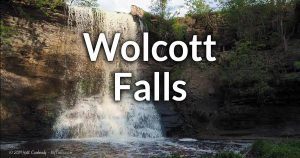
Maxwell Creek Falls


Location: On the south side of Lake Rd, across from Camp Beechwood State Park; town of Sodus; Wayne County; New York.
Maps: Google Map; Topographic; Interactive map.
GPS Coordinates:
- Maxwell Creek Falls: N 43.26285 / W 77.02534
- Parking: N 43.26445 / W 77.02545
Directions: Take NY-104 into the village of Sodus, and then head north on Maple Ave (CR-134). Make a right onto Maple Ave Cuttoff and then another right onto Lake Rd (CR-101). Follow Lake Rd for 1.9 miles and as you pass Camp Beechwood State Park on your left, look for a small gravel parking area on your right. If you pass over the creek or pass the Maxwell Bay Fishing access site, you have gone too far. Or use Google Maps.
Parking: A small gravel parking area has room for about 6 cars. It may get packed in fishing season. There’s a small historic marker on the east end of the lot.

Weather
Information / Accessibility / Accommodations
Number of falls: 1.
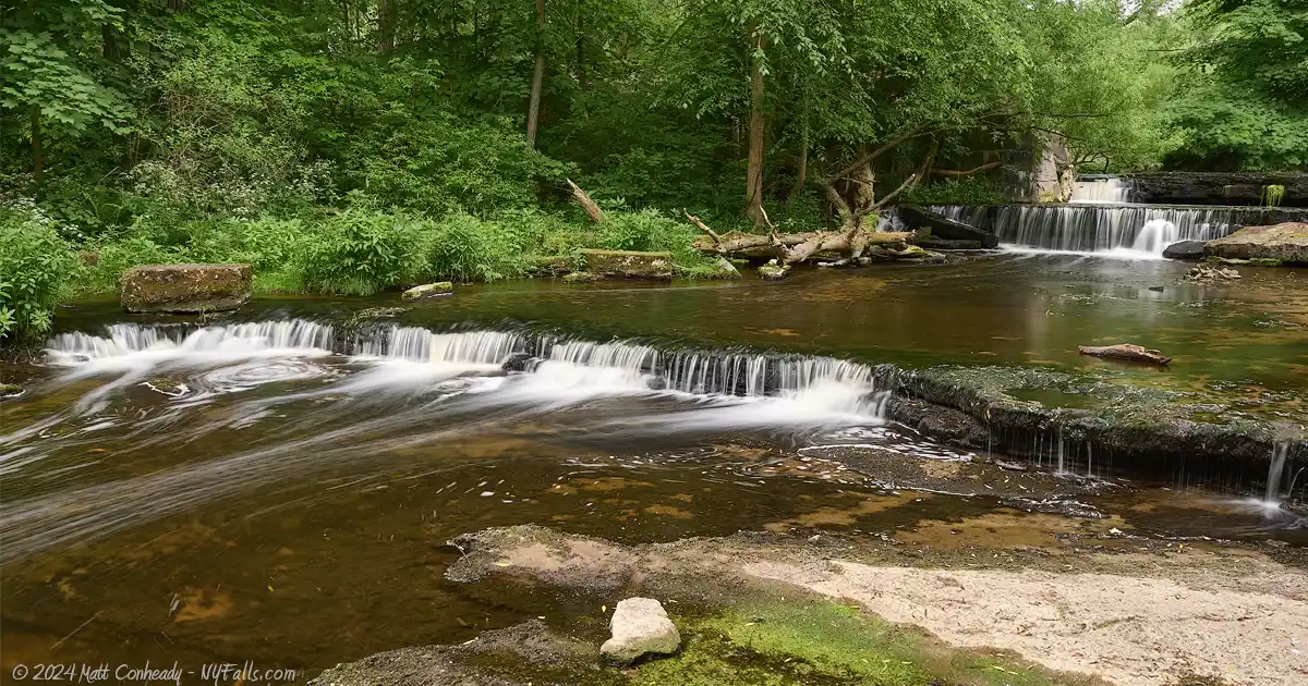
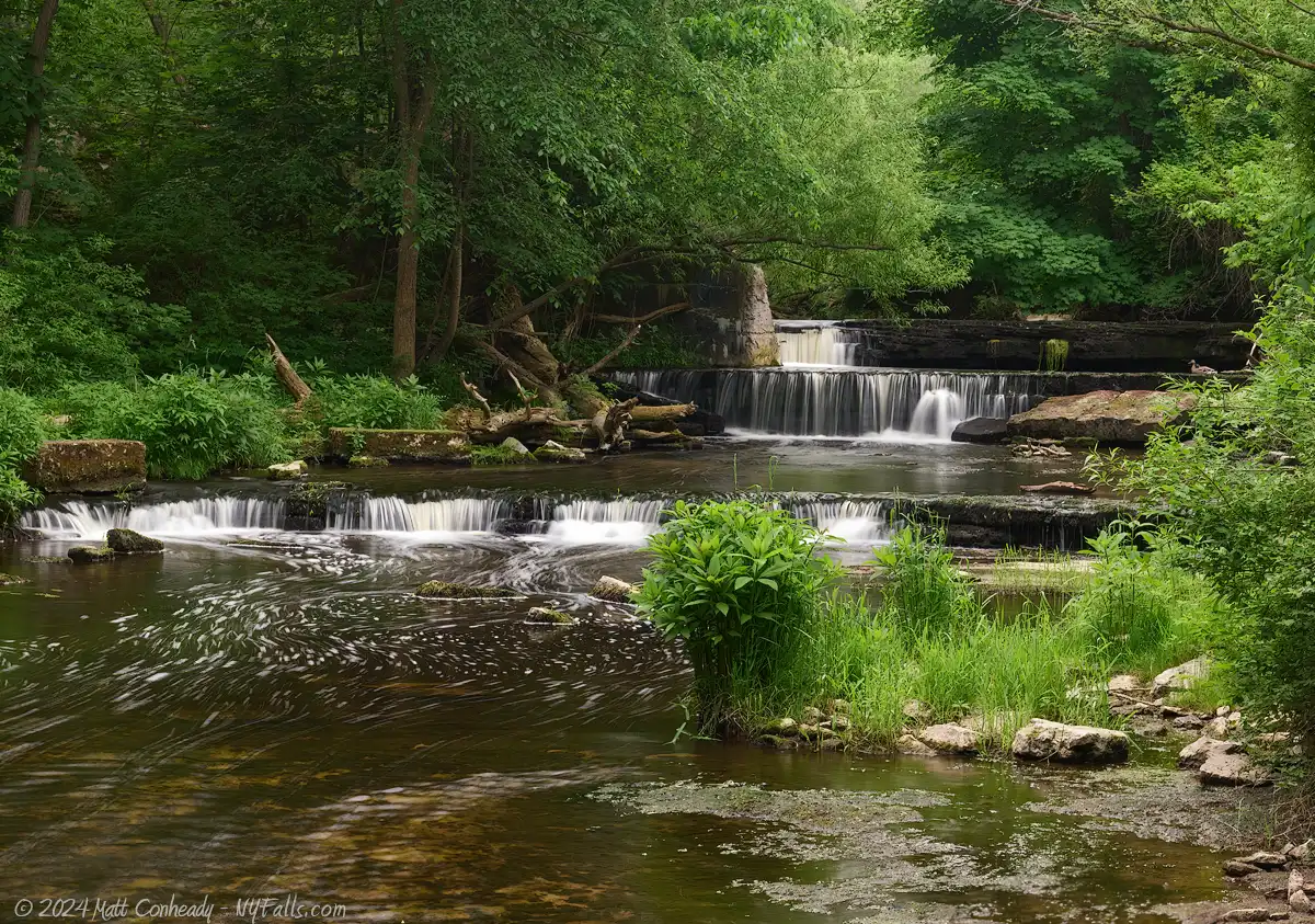
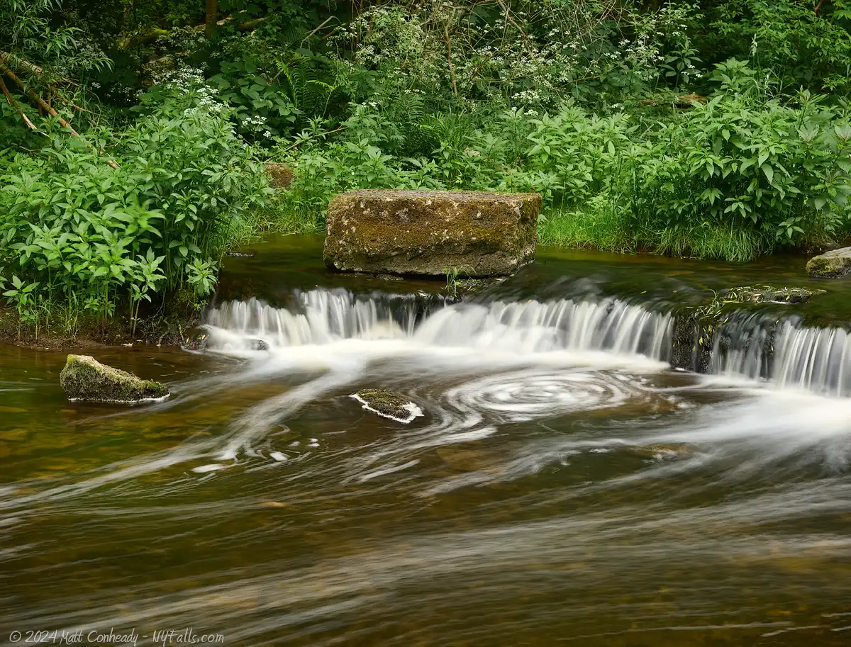
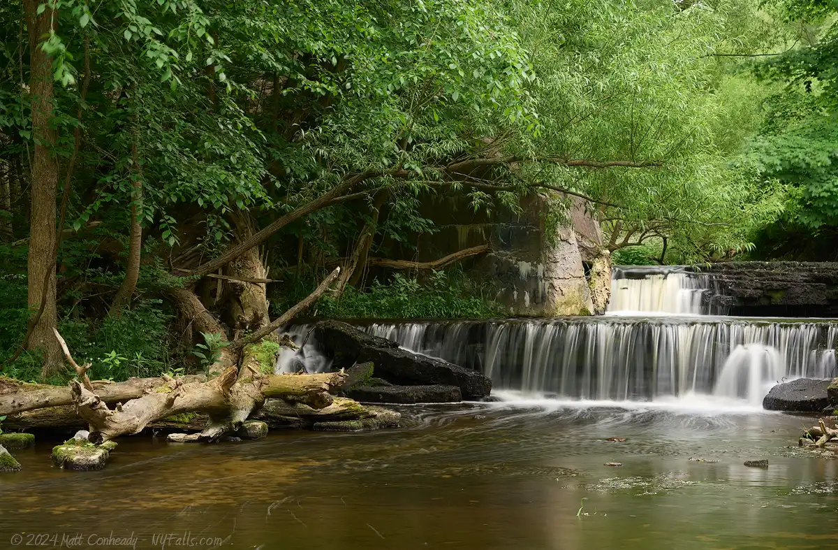
Size/Types: A 15 foot cascade in 3 steps within an old mill/dam complex.
Best time to visit: Spring or after a period of rain.
Flow: Low.
Waterway: Commonly known as Maxwell Creek, the USGS, old maps and history books have this waterway identified as “Salmon Creek.” Salmon Creek originates just southeast of Williamson and flows southeast for about 3 miles, cutting through the town of Marion and making its way into the town of Sodus. There it heads eastward for 6 or 7 miles to Metz Pond. After the pond and falls, it goes directly north for about 4 miles to the falls here. After the falls, it crosses under Lake Rd and empties into Maxwell Bay at Camp Beechwood State Park and the Preston-Gaylord estate on Lake Ontario. Lake Ontario flows eastward through the St Lawrence River and out into the Atlantic Ocean at the Gulf of St. Lawrence.
Time: 1 minute from the lookout deck, 10 minutes taking the trail to the bottom.
Seasons/Hours: Year round.
Parking: Roughly 12 cars.
Admission: Free.
Handicap accessibility: The observation deck is.
Pets: Allowed on leash.
Accommodations: Restrooms; picnic tables; playground; hiking trail; pavilion; historic information kiosk; historic marker; observation deck. There are shops and restaurants not too far from there in the village.
Description
AKA: Falls on Salmon Creek; Salmon Creek Falls.
Salmon Creek (also known as Maxwell Creek) flows through heavy agricultural areas as it meanders around Wayne County, making its way toward Lake Ontario at Maxwell Bay, a small bay in the shadow of the greater Sodus Bay. Because of the fertilizers used, the stream picks up an overwhelming amount of nutrients, leading to algae blooms, turning the stones along the creek a bright green by mid summer. In the fall the algae tends to die off, turning the creek a dark brown. As the old algae blooms decay, they form a layer of slimy mud on the bottom of the creek. Still, the creek here is relatively healthy and landlocked salmon make their run up the bay and stream, with many leaping up the falls to spawn. On the north side of Lake Rd is a DEC fishing access site, that will get very busy in the fall. Those in the know, will fish the south side of the road, here at the falls. Spring is a good time for waterfall fans to visit. The influx of seasonal rainwater clears out much of the gunk and the surrounding flora is lush and peaceful.
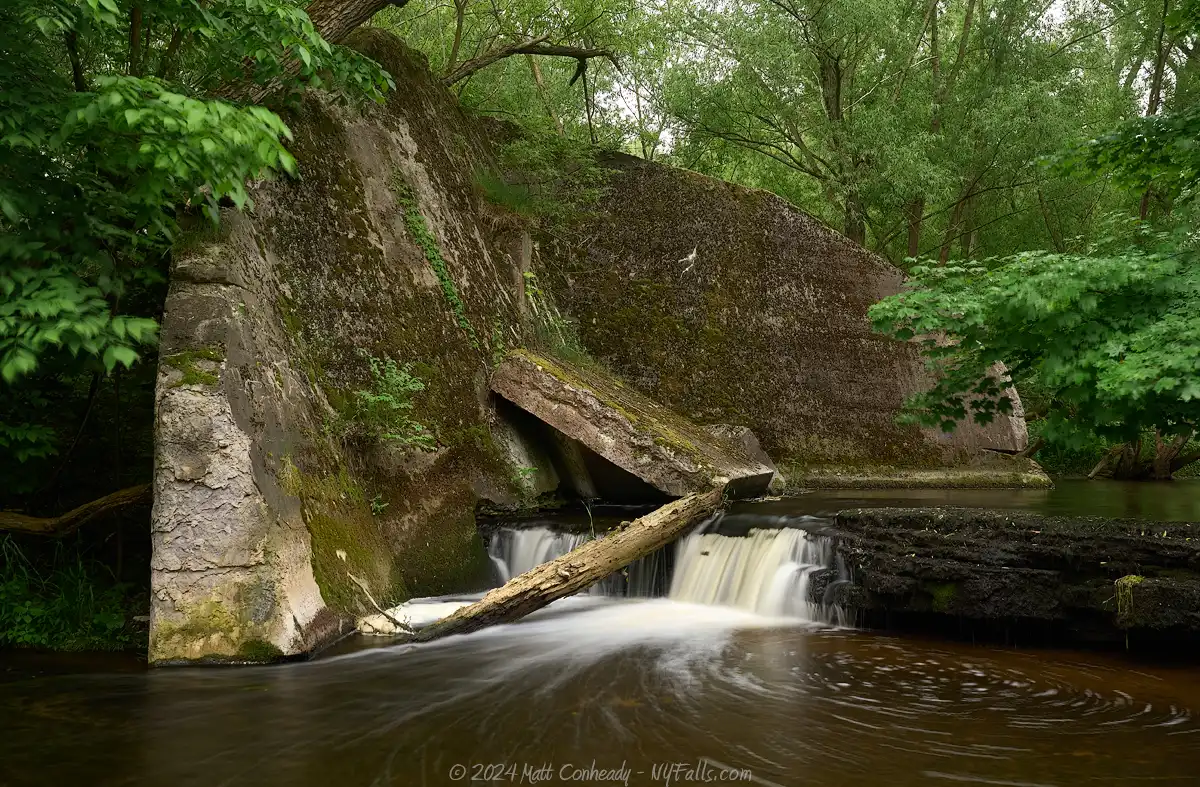
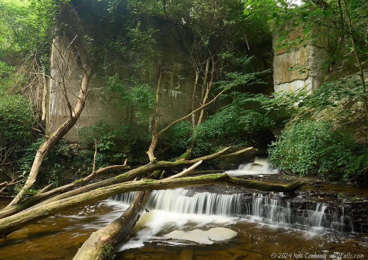
A narrow trail from the parking lot runs up the west side of the creek, but some do creek walk here. If that’s your plan, I would recommend waders or a change of shoes. From the parking lot, the falls is just 500 ft to the south. It falls about 15 feet in three steps. At the very top is a large concrete barrier. It was once a part of a large mill complex, where it diverted half of the creek’s flow to a mill pond. The decaying concrete mill structure is on the other side of the creek, and is accessible if you creek walk, or if the falls is relatively dry.
While this is not the prettiest of falls, it’s one of only a few in the county and a very easy stop if you are passing through or visiting other local parks, such as Camp Beechwood or Sodus Point.
History
The land along Salmon Creek was originally owned by Revolutionary War Captain John Maxwell (1739-1828), who constructed a gristmill on the east side of what is now called Maxwell Bay in 1794.
Dr. William Nixon Lummis (1775-1833), a physician in Philadelphia, came down with a bout of yellow fever, which caused his health to decline. Seeking a peaceful retreat, he moved his family to the Genesee Valley in Pennsylvania, and eventually they migrated north to Sodus Point, where he purchased 1,000 acres on the east side of the bay, in an area now known as Lummisville (where NY-104 passes through). After the death of his wife, he married Sarah Maxwell, daughter of Captain John Maxwell. In 1812, he relocated to Salmon Creek on the Captain’s land, where the original mill was freshly rebuilt that year. When war broke out, and the British attacked Sodus Point, the Lummis estate he left was destroyed. Dr. Lummis ended up buying the mill and land from his father-in-law. Years later, Dr. Lummis also built a sawmill and a forge to the south, near the millpond and falls, as well as a handful of small homes for the workers. Many of the inhabitants of their new hamlet were freed slaves, giving rise to the unofficial name of “colored settlement.” Dr. Lummis named the place “Maxwell” in honor of his wife’s family name. While accurate records of Underground Railroad stops are not easy to come by (for obvious reasons), it is said that the settlement of Maxwell, as well as other homes in the area, were stops. The community had a wood shop, blacksmith, scythe shop, tannery, and several mills along Salmon Creek. It thrived for over a century, but little of it remains now.
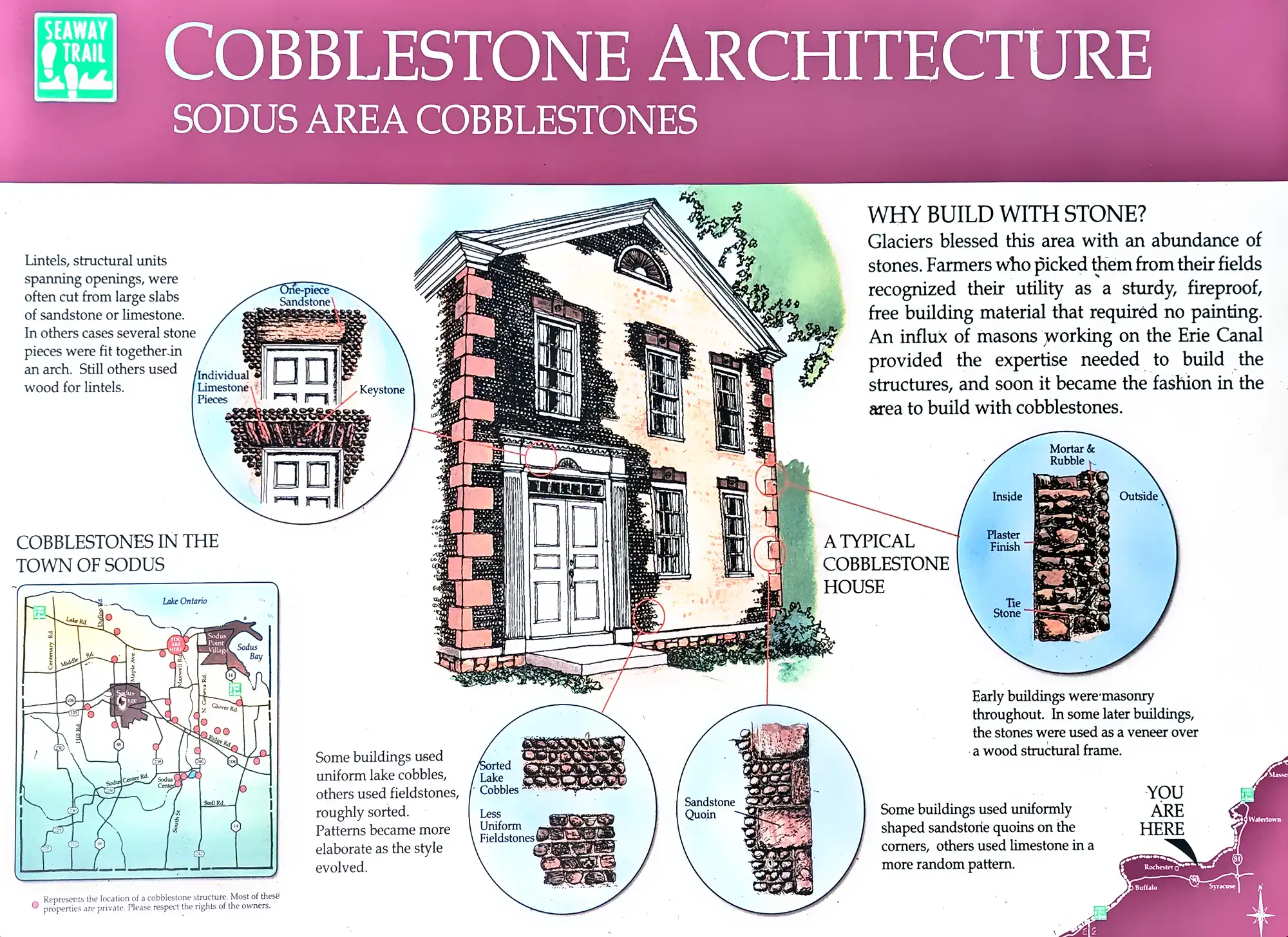
The historical signage in the parking area has information about regional cobblestone houses. It doesn’t explicitly call it out, but just to the north, across Lake Rd and on the east side of the bay is the Preston-Gaylord estate. The cobblestone home was built in 1846 by William Swales for his daughter Elizabeth, who was married to John Preston. The cobbles used in construction were plucked from the beach along the lake. The porch and carriage house were added in the 1870s. The gristmill, originally built in 1794, then rebuilt in 1812, was a part of the estate. The mill ran continuously into the 20th century, gaining a name for producing “the best wheat flour of any mill in this region.” It converted to stream power around 1915, but due to a crumbling foundation, it was torn down in 1920. The foundation is all that remains today. The home remained in the family for over 150 years.
I could not find a source for the construction of the concrete barrier and mill structure found above the falls. If you happen to know, reach out to me.
Hiking / Walking Trails
Difficulty: Easy, but the trail can often get overgrown, especially in spring. Sometimes it’ll be muddy. Dress appropriately and be sure to apply insect repellant.
Distance: About 600 ft from the parking area to the falls.
Markings: None.
Description: From the parking area head south (away from the the road) into the woods. At times there are two paths heading in. Take either one; they go to the same spot. The trail will come close to the creek then back away, but never too far. Keep the creek on your left and listen for the falls. Once at the falls, you can creek walk and climb to the top, or cross the creek to see the old mill structure just beyond the trees on the opposite side.
Maps: Interactive.
Maxwell Creek Falls Interactive Map
Interesting Stuff
Pre-emption line
One of the original territorial lines that divided New York and Pennsylvania runs through this property. In the 17th century, Charles I granted lands to Massachusetts Bay that stretched from the Atlantic to the Pacific. Later, his son Charles II granted similar lands to New York when creating a new colony for his brother James, the Duke of York. This was mostly because maps, and people’s understandings of them, sucked back then.
The conflicting land claims of Massachusetts and New York were settled in 1787 by the Treaty of Hartford. Surveyors marked the Pre-emption Line, which defined New York’s territory once the Seneca land title was acquired. The line, intended to run north from Pennsylvania to Lake Ontario, and ran through this area at Salmon Creek, veered west due to navigational errors or intentional deviation. This created a disputed area known as the Gore. By the time the line was resurveyed in 1794, much of the land had been sold, and early settlements within the Gore were initially uncounted in the 1790 census. It caused a lot of map issues and disputes for the next hundred years or so.
Fishing Access Site on Maxwell Bay
The larger fishing access site on the north side of Lake Rd and the opposite side of the creek has a larger parking area and a short path that leads to the shore of the bay.
Camp Beechwood State Park
Just across the street on Lake Ontario is this former Girl Scout camp, which sat abandoned for years, now opened as a state park and campgrounds for the public. While work has been going on to refurbish the park, several ruins of old structures and many traces of the old camp on Maxwell Bay can still be found if you explore enough.
Photography Tips
Fishermen
- Photograph in fall to capture fishmen along the creek and often fishing near the falls.
Silky Water Effect
- To get that smooth cotton-candy look to the falls, you need to use a Neutral Density (ND) filter on your lens. The ND filter will block some of the light from entering the lens without altering the color, and thus allow your shutter to stay open longer. This blurs the water and creates a soft white gloss to the foamy areas of the falls. Check out the article for the all the details.
More tips
- See the Articles for more photography tips.
Who to Contact
No contact information