Cazenovia Park Falls
Location: In the City of Buffalo; Erie County; New York.
Maps: Google Map; Topographic; Interactive map.
GPS Coordinates : Waterfall: N 42.84940 / W 78.80858
View from Cazenovia St Bridge: N 42.850767 / W 78.809158
Closest parking: N 42.84876 / W 78.80622
Directions: Cazenovia Park is located on the southeast corner of the city of Buffalo.
Warren Spahn Way runs through the park and NY-16 (Seneca St) runs parallel to its northern edge.
Take NY-16 (Seneca St) to Warren Spahn Way, which is the park’s road. Once in the park, turn right to go to the side of the park with the baseball diamonds.
Use Google Maps for specific directions.
Parking: Roadside parking wherever you can find a space along Warren Spahn Way. Pretty much this whole road is lined with parking spots.

Weather
Information / Accessibility / Accommodations
Number of falls: 1
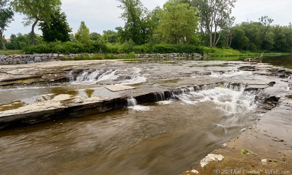
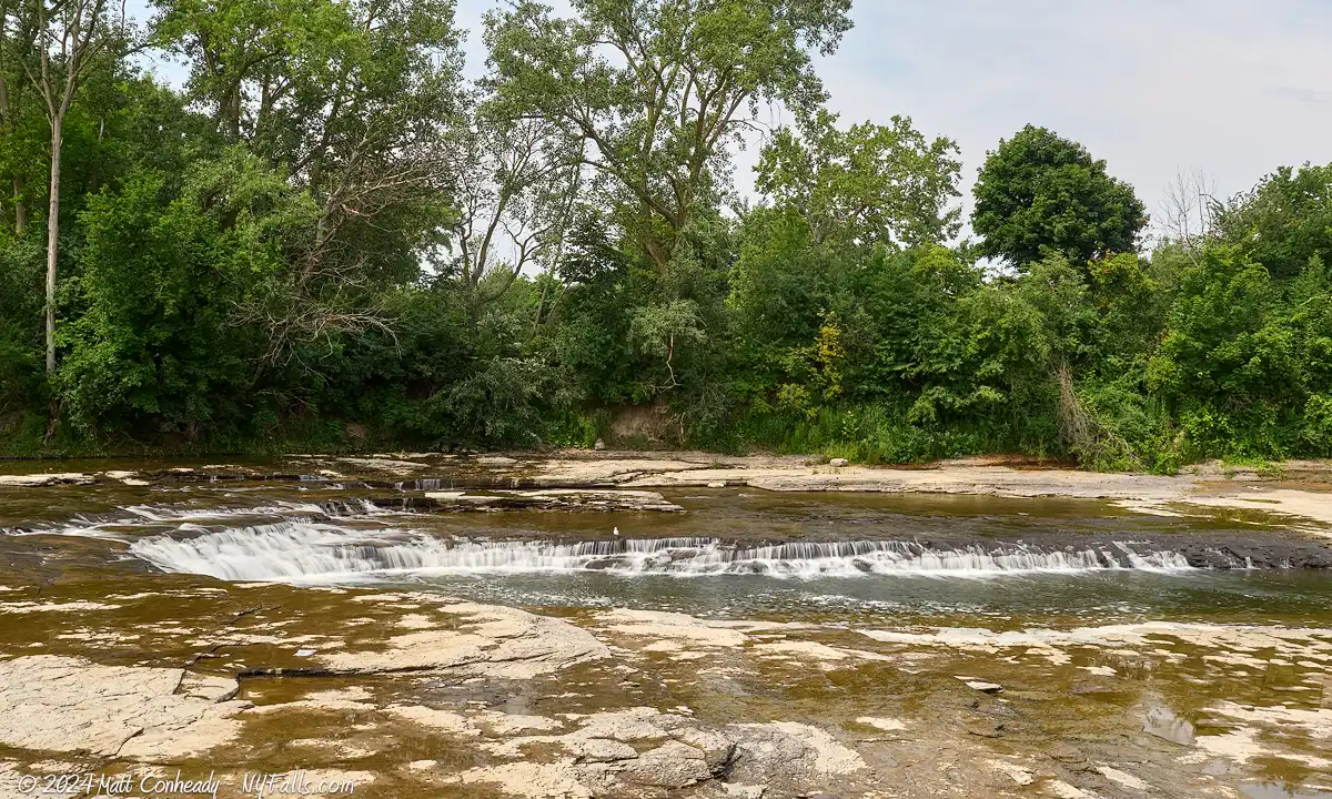
Size/Types: A series of V-shaped shale ledges totaling 4-5 ft in height. The creek at this point can be up to 165 ft across. While high water levels increase the width of this falls, it also tends to make it look simply like a small patch of rapids. The center of the V has a deeper channel (about 6 inches) of water that some people wade in.
Best time to visit: Year-round.
Flow: Good.
Waterway: Cazenovia Creek. The East and West branches of Cazenovia Creek come from the southern edge of Erie County, join together in the town of Aurora becoming just Cazenovia Creek. It continues northwest into the city of Buffalo, through this park, and empties into the Buffalo River just before the Buffalo River empties into Lake Erie, near the Erie Basin Marina, Naval & Military Park, and the Buffalo Lighthouse Park.
Time: 15 minutes.
Seasons/Hours: Year-round, from dawn until dusk.
Admission: Free.
Handicap Accessibility: Yes, there is a paved path alongside the creek.
Pets: Allowed, on a leash.
Accommodations: Restrooms; 9-hole golf course; baseball diamonds; soccer fields; tennis courts; basketball courts; playgrounds; spray pool; swimming pool (indoor); walking path; indoor ice rink; many nearby shops and eateries in the city.
Description
AKA: Caz Park Falls.
Cazenovia Park is a beautiful 83-acre community recreation park in the city of Buffalo. It is one of a handful of Olmsted Firm-designed parks in the Buffalo region. Olmsted parks have a rich history of urban recreation, with their natural design theory and grand buildings. Cazenovia Creek runs through the middle of the park and drops down a short, but wide, waterfall at the northern end of the park. While the falls itself is nothing worth venturing cross-state for, it is a nice thing to stop and check out for those in the area.

Hiking / Walking Trails
Difficulty: Easy. Level, mowed grass.
Markings: None.
Distance: About 800 ft.
Description: Park on the side of the road near the first baseball diamond and the park shelter.
- Work your way to the shelter and find the paved path just south of the shelter/restrooms.
- Take the path west toward the creek where it will turn north.
- Just after that turn the falls will be on your left. An opening in the trees will allow you access.
You can also see the falls from the Cazenovia St Bridge:
- Continue north on the path past the falls. It will loop around the ball fields and head toward the intersection of Cazenovia and Warren Spahn Way.
- Turn left on Cazenovia and follow the sidewalk to the bridge.
Map: Interactive.

Cazenovia Park Falls Interactive Map
History
This land was originally farmland owned by William Hart. It was purchased in 1890 by the city of Buffalo for construction of a park.
Designed by the Olmsted Firm from 1892-1894, a dam was constructed across Cazenovia Creek creating a recreational 20 acre lake for fishing and boating within the park. The dam was located where the Cazenovia St bridge is now (the road did not appear to cross the creek at the time) and flooded a great deal of the northern part of the park (including the current location of the baseball diamonds and the waterfall). The lake extended south to where the Warren Spahn Way bridge is today. Sections of the creek were re-routed as well. Aside from the lake, one of the park’s first structures was a bandstand, surrounded by a shaded sloping lawn.
In 1902, the Shelter House was constructed and used for guests’ meetings and as a rest area. It was much smaller than the park designers had hoped, but this was all the city had a budget for. This still exists in the park today.
In 1912, The Casino was built on the east side of the lake. The two-story building served as a boathouse, had locker rooms, an ice cream parlor, candy shop, and kitchen. It also had lights that shone down on the lake in winter for nighttime ice skating. Its large open 1st floor had seating for park guests. The basement was used to store boats.
From the start, the lake has experienced multiple floods, sewage backups, and silt build-up. It was dredged, and a new dam was constructed to help control flooding. The lake was originally built with 2 islands, but during the restoration work on the lake in 1913, they were merged with the southern bank to create a peninsula, forming a lagoon on the west side of the lake. A stone bridge was added to connect the peninsula with the northern side of the lake.
Baseball diamonds and tennis courts were added in 1915.
In 1953, the bandstand was removed. In 1965, as a part of the city’s efforts to control flooding, the dam was removed and the lagoon drained. The eastern end of the lake was more of a muddy swamp after this. The old lake-bed remained sort of swampy until it was filled in in the 1970s.

Casenovia Park Media
Videos


Photography Tips
Waterflow
- This waterfall is not very tall and has an interesting shape that is, unfortunately, hidden in higher water flow. I photographed in lower flow and the photos lack a bit of drama. I recommend targeting moderate flow for a mix of water action while still being able to see the interesting shapes of the underlying rock.
Silky Water Effect
- To get that smooth cotton-candy look to the falls, you need to use a Neutral Density (ND) filter on your lens. The ND filter will block some of the light from entering the lens without altering the color, and thus allows your shutter to stay open longer. This blurs the water and creates a soft white gloss to the foamy areas of the falls. Check out the article for all of the details.
More tips
- See the Articles for more photography tips.

Who to Contact
Buffalo Olmsted Parks Conservancy (BOPC)
716-838-1249
bfloparks.org/contact/


