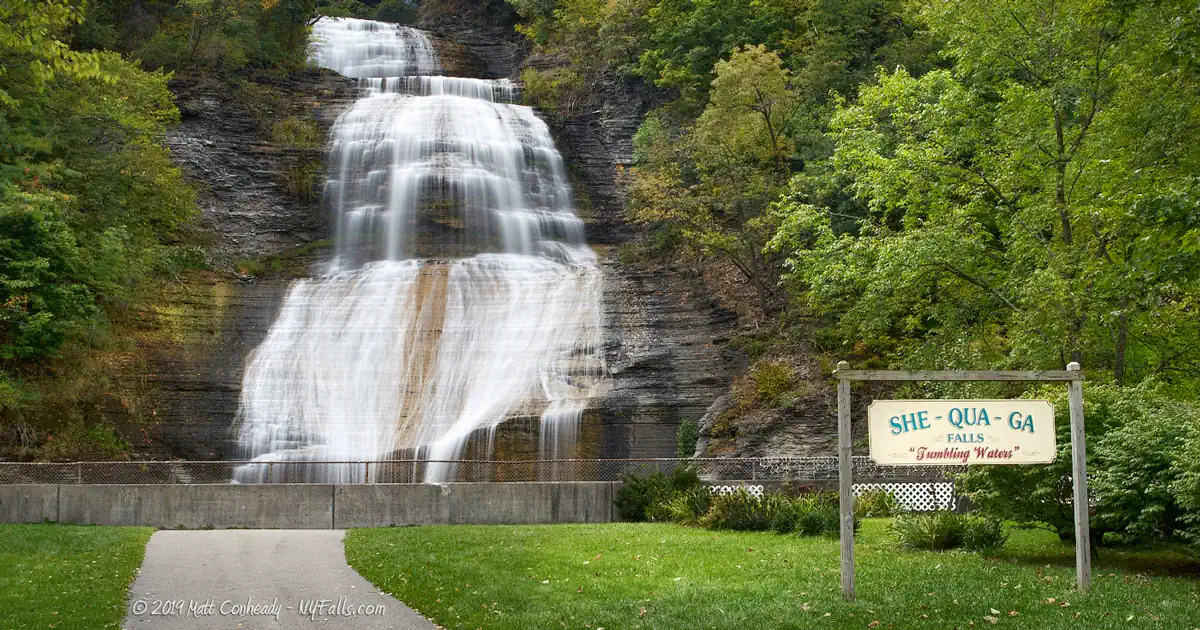
SheQuaGa Falls, Montour Falls


Location: Village of Montour Falls, town of Montour, Schuyler County, New York.
Maps: Google Map; Topographic; Interactive.
GPS Coordinates: Falls: N 42.34453 / W 76.85136
Directions: Take NY-14 to Montour Falls and turn west onto W Main St. You should see the Falls at the end of the road. Park along Genesee St.
Or use Google Maps.
To get to the crest of the falls, head north on Genesee St and make a left on to Steuben St, which will get you to the top of the escarpment. Make a left onto Mill St. Follow Mill St for roughly 600 ft at which point it crosses over the top of the falls.
Parking: Roadside parking only. There are a few dedicated spots along the road in front of the park with 30 min limits. Plenty of side streets to park along within walking distance. Check the signs.

Weather
Information / Accessibility / Accommodations
Number of falls: 1.
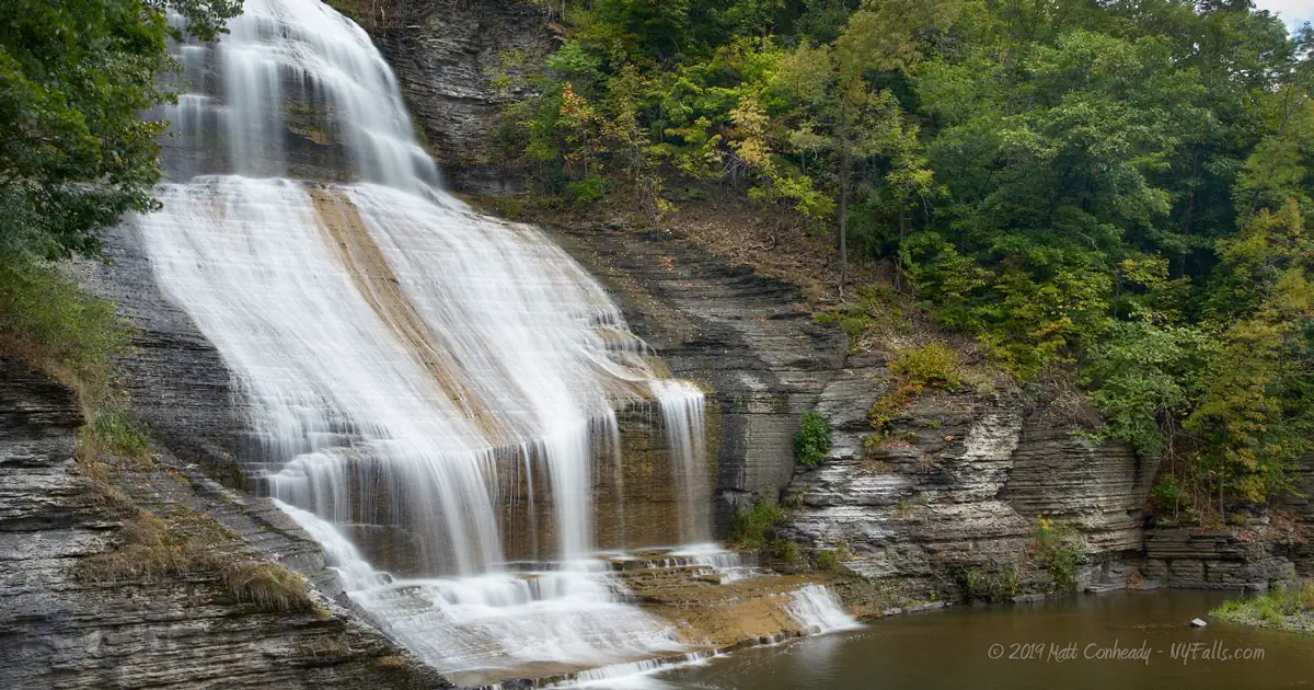
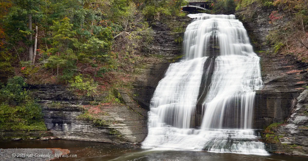
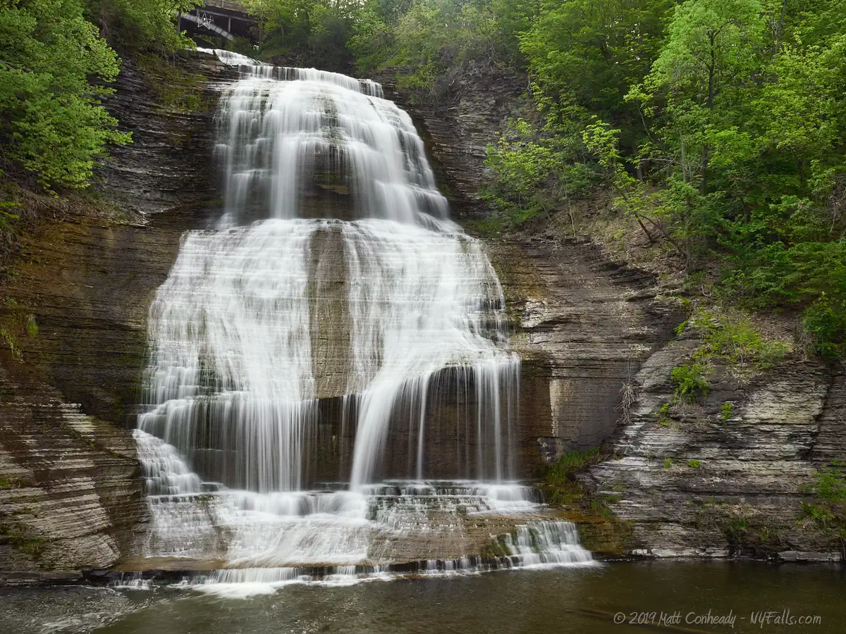
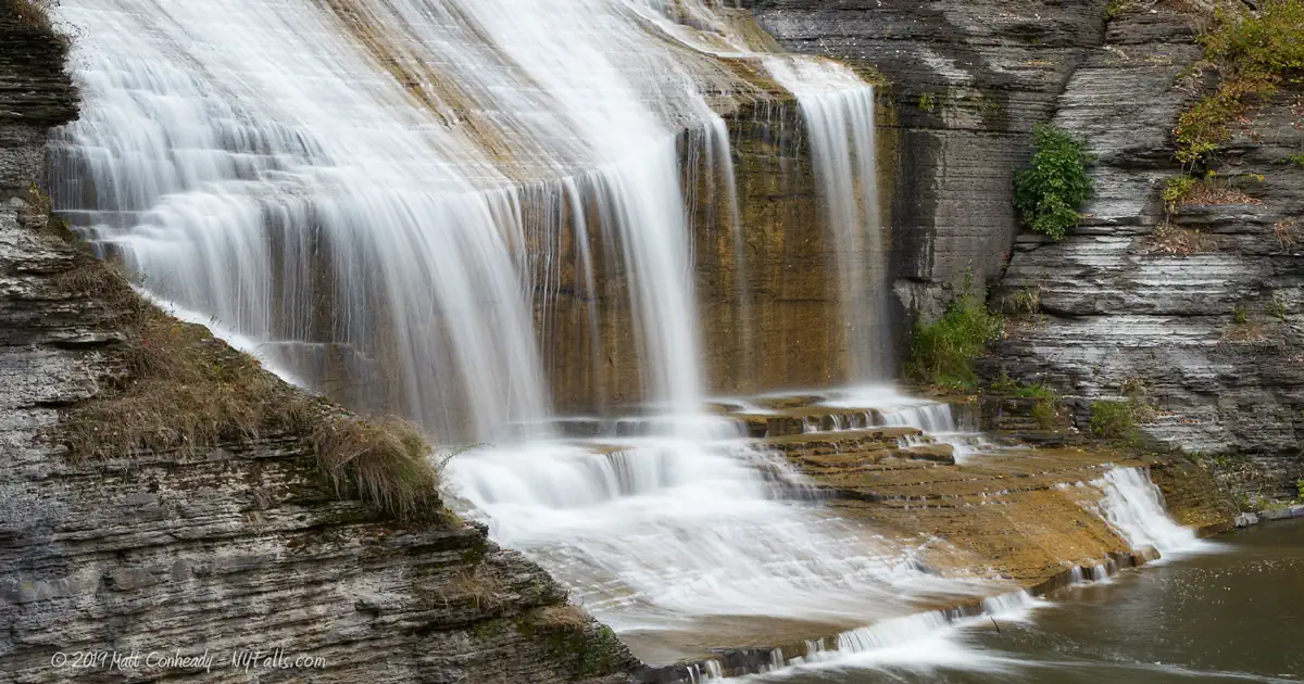
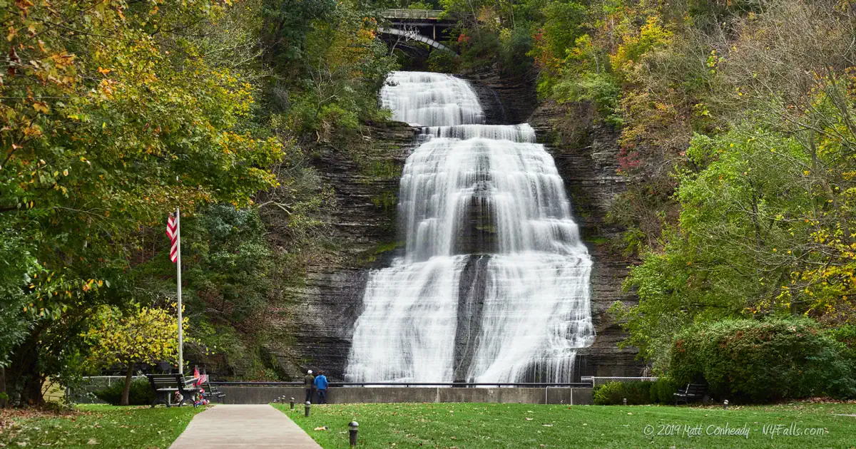
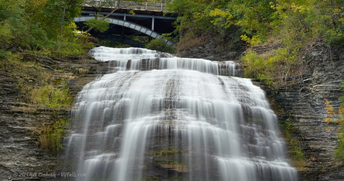
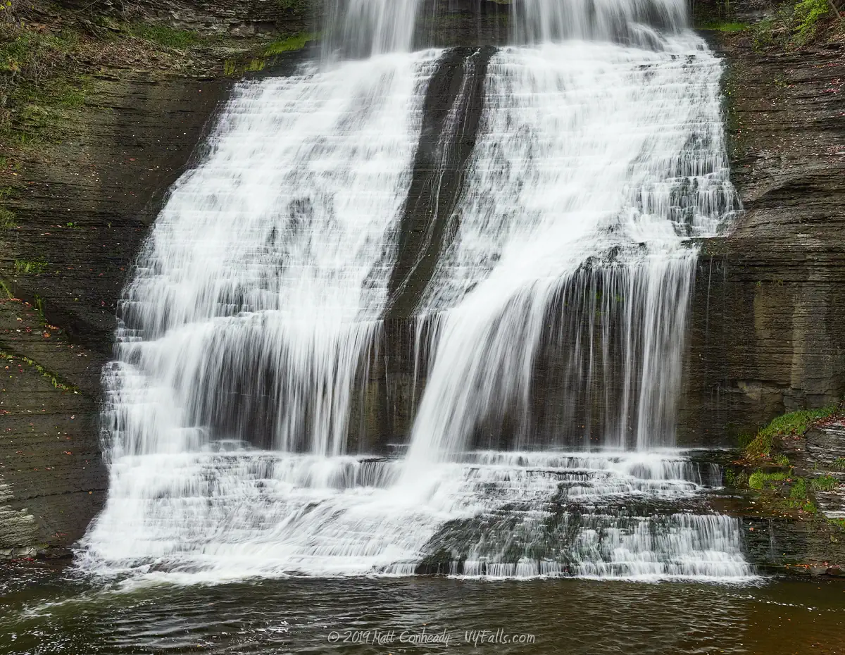
Size/Types: A large frothy cascade, 156 ft in height. It passes under the Mill Street bridge as it starts and empties into a large pool at the bottom. The creek then turns north entering a tunnel that takes it under N Genesee St.
Best time to visit: Year-round.
Flow: Consistent. Rarely completely dry.
Waterway: Shequaga Creek, which begins in the hills 8 miles west of here near Baker Hill in the town of Dix. Shortly after falling over Shequaga Falls, it turns to the north, flowing through a tunnel under the road and meandering north and emptying into the Seneca Lake Inlet just north of the village at the marina. The Seneca Lake Inlet travels almost straight north, through the village of Watkins Glen, and empties into Seneca Lake near Lakeside Park.
Time: You can drive by and see the falls, or park and walk to the falls in under 5 minutes.
Seasons/Hours: Park open year-round. The falls and walkway are illuminated at night.
Admission: Free.
Handicap accessibility: Yes, there is a paved walkway from the street to the end of the park.
Pets: Allowed on leash.
Accommodations: Paved walkway, benches; historical marker. A bed & breakfast operates next door.
Description
AKA: Havana Falls (historically) and sometimes Montour Falls. Often spelled “Chequaga”
Pronounced: She-kwa-gah
Driving down Genesee Street in Montour Falls can be a surprising experience, as the massive Shequaga Falls suddenly emerges from behind the quaint houses lining the road. It almost feels out of place unless you’re familiar with the stunning natural landscape of the area. On Main Street, you’re treated to one of the most picturesque small-town scenes in the state of New York. Montour Falls, despite its seemingly flat appearance, sits just south of Seneca Lake within a dramatic section of the Portage Escarpment, carved by glaciers 18,000 years ago. This region is a true “waterfall mecca,” with towering cliffs over 300 feet high, channeling countless streams and significant waterways down the escarpment.
The crown jewel of Montour Falls is undoubtedly Shequaga Falls, a powerful cascade that crashes down the cliffside on the western edge of town. The falls seem to originate from the iconic arch bridge above, though they actually begin just before it, fanning out as it tumbles over the rugged gray limestone before reaching a shallow plunge pool below. From there, the creek makes a sharp 90-degree turn, continuing its journey northward toward Catharine Creek and eventually emptying into Seneca Lake.
Nestled between the “At the Falls Bed & Breakfast” and a neighboring residence, a small park invites visitors to experience the falls up close. Open to the public, this peaceful oasis stretches from the road to a chain-link fence overlooking the creek below the falls, which is majestically illuminated after dark. It’s a popular spot for travelers, offering a few moments of serenity and awe without requiring much effort—a quick but memorable detour that perfectly captures the charm and natural beauty of Montour Falls.
History
Montour Falls, like the village of Watkins Glen, is nestled within the basin of Seneca Lake. The region was once covered by an ancient ocean, which deposited layers upon layers of sand, silt, and clay which formed the characteristic rock layers that define Finger Lakes region geology. The evaporation of the ocean led to the formation of massive deposits of salt crystals, which are harvested by US Salt at a plant north of Watkins Glen. When the last ice age covered much North America with massive glaciers (around 20,000 years ago) they carved out an old river valley, forming the basin here and leading to the jagged and towering cliffs that our modern day waterfalls call home.
Catharine Montour, or Queen Catharine, was a matriarch of the Seneca tribe of the Iroquois during the late 1700’s. The daughter of Peter Quebec, a Mohawk Chief, and Marguerite Fafard Turpin, a daughter of an Oneida chief and French Canadian, her knowledge of English, French and various native languages made her a critical figure in dealing with native tribes, surveyors, traders, and then white settlers as the area became colonized. Catharine married a Seneca chief Telenemut, aka Thomas Hudson, which led to her colloquial title “Queen Catharine.” When the Seneca tribe called this region home, their settlement here was known as Queanettquaga (or sometimes Che-o-quock, Shughquago, or Sheoquago) as well as Catharine’s Town (or Catharinestown and sometimes Catharine’s Landing) to white settlers. It was located on a hill a bit south of the present-day village. The nearby hamlet of Catharine and also Catharines Creek are also named after Queen Catharine.
The Seneca-inhabited Catharine’s Town was destroyed in August of 1779 during the Sullivan Expedition during the Revolutionary War. Some sources tell of the village being completely abandoned by the time Sullivan’s army arrived, yet still, the troops demolished it completely. Along with the departure of the Seneca, and the subsequent destruction of the villages, much of the pre-colonial history of the region vanished.
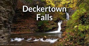
Rebuilt by non-native settlers, who began arriving as early as 1788, the new settlement was then called Mills Landing after early settler George Mills of Pennsylvania, a Revolutionary War soldier who arrived in 1788, but didn’t establish a permanent residence until 1790, when he constructed a shanty and, in 1805, opened a store and tavern (but not a mill). The name comes from George Mills’ propensity to sail Seneca Lake from the Inlet at his property. Despite the obvious presence of water power from Shequaga Falls, for the first several decades of the early settlement, only a small footpath led to the falls and up the hillside.
The first mill was the Decker Flouring-Mills, erected in 1802 or 1803 on Decker Creek (at Deckertown Falls), by Bowers and Kimball. A linseed oil mill was erected near there in 1836 by William T Jackson, and it was converted to a woolen mill a short time after. Jackson, a justice of the peace for the village, and later a US congressman, had a house on the property that is now the park at Shequaga Falls. In 1828, a plaster mill was constructed by David Lee and Nathan Hall at the base of the falls and with that, the next 70 years saw a boom of industry from Mill Street that cuts through the top of Shequaga all the way to what is now Steuben St.
The village was incorporated on May 13, 1838 as Havana, named for the city in Cuba.
From 1827 to 1833 the construction of the Chemung Canal, which connected the Chemung River to Seneca Lake, opened a significant trade route, with Mills Landing being an important stop and trade center. Factories and shops sprung up in the middle of the village and along the canal, including six stoneware manufacturers. Their products became well known in the northeast as “Havana Pottery.”
By 1874 the hillside was packed with mills and factories, including a tannery, saw mill, woolen mill, foundry, plaster mill, and yeast-works. Many of the prominent business owners had homes in front of the falls along Genesee Street. Many of the businesses didn’t survive through the turn of the century and the great depression.
The village (and town) adopted the name Montour Falls, in honor of Catharine Montour, on March 20, 1895.
A historical marker notes: that around 1820, French royal, Louis Philippe, who would later become the last king of France, toured the Finger Lakes region and made a sketch of the falls which is on display at the Louvre Museum in France. Well, the sign is likely wrong. The sketch was most likely done by his brother, the Duc Monpenier, and that and any relevant artwork created by the family pertaining to Schuyler County was stolen or destroyed when the communists burned down most of the Royal Family’s home in 1971. It’s possible the work still exists today, somewhere, but definitely not hanging in the Louvre. Source: the Louvre.
Another truth to another myth. The name Shequaga is a name given to the falls by Thomas Maxwell (1792-1864) an attorney and US Representative who lived in Geneva, NY. Maxwell, was the son of an Irish-born trader who was “adopted” by the Seneca. Maxwell grew up within Seneca culture. As a hobbyist historian, Maxwell contributed his knowledge of the culture and language to white settler history by naming several natural landmarks with Native American names, usually long after the Seneca were extinguished from the area. The name he chose here was likely borrowed from the Casconchiagon (Seneca village at Lower Falls in Rochester), and likely is not the original Seneca name for the falls here.
The famous Seneca chief and orator, Sagoyewatha or Red Jacket was said to practice speaking in front of the roar of the falls. I couldn’t verify this trivia as fact.
Hiking / Walking Trails
Difficulty: Easy.
Markings: None.
Distance: 120 ft from the road.
Description: This falls is easily visible from the road, and a paved walkways will take you to the viewing area at the base. Be mindful of private property on either side of the small park.
There’s more to the falls than what you can see here. If you drive up to the Steuben St bridge where it crosses over the falls, you can see a bit of the upper portion of the falls, but unfortunately there’s no place to park for a longer look.
Maps: Interactive map.
Shequaga Falls Interactive Map
Interesting Stuff
Illumination
Visit at night to see the falls illuminated with white light.
Seasonal Falls
After periods of rain, a thin seasonal falls will flow just to the north. This seasonal stream served as a raceway to power mills that lined Mill and Steuben Streets in the 1800s. You may be able to see it from between the houses on N. Genesee Street if the flow is high enough.
Catharine Valley Trail
When completed, it will extend 12 miles from Watkins Glen State Park to Mark Twain State Park in Horseheads, NY, passing through Montour Falls along the way. The trail follows the old Northern Central Railroad and the Chemung Canal towpaths with multiple historic sites along the way.
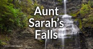
Aunt Sarah’s Falls
Just north of here is this smaller roadside falls that’s easy to see as you drive by or pull over into the small park across the street to relax and enjoy.
Historic Montour Falls Library
The Montour Falls Memorial Library, originally the Bank of Havana, was designed by Charles Cook and built in 1864 by Gillispie and Coreyell. It became a library in 1901 and was added to the National Register of Historic Places in 1993. The building retains much of its original charm, including woodwork, furniture, and a fireplace, with additions like Tiffany stained glass windows and a distinctive south-facing entrance added around 1906. The library’s bricks, along with those of the Village Hall and Village Office Building, were made from locally harvested clay, and all three buildings feature unique round brick pillars. Since its establishment, the Montour Falls Library has been a cornerstone of the community, continuing to serve Schuyler County and beyond with a strong community-focused mission.

10 Must-Visit Waterfalls In New York State
A selection of the most popular and accessible waterfalls around the State of New York. From Niagara Falls in Western NY to Kaaterskill Falls in the Hudson Valley Region.
Photography Tips
Photographing the Falls
- Shoot from the road-side end of the park to include the sign and scenery and to give scale to the falls. The down-side is that the bottom of the falls will be clipped by the barrier.
- Shoot from the barrier to include the bottom of the falls, but you won’t be able to see the top.
Overcast skies
- This frothy waterfall sparkles in sunlight which will cause exposure problems. It is best to wait for an overcast sky for this one.
Silky Water Effect
- To get that smooth cotton-candy look to the falls, you need to use a Neutral Density (ND) filter on your lens. The ND filter will block some of the light from entering the lens without altering the color, and thus allow your shutter to stay open longer. This blurs the water and creates a soft white gloss to the foamy areas of the falls. Check out the article for the all the details.
More tips
- See the Articles for more photography tips.

10 Must-Visit Waterfalls Around Ithaca, NY
A selection of the most popular and accessible waterfalls around Ithaca in the Finger Lakes Region of New York.
Who to Contact
Shequaga Falls Park
Town of Montour
Havana Glen Road
P.O. Box 57
Montour Falls, NY 14865
Phone: (607) 535-9476
townofmontour.com