Whitaker Park Falls


Location: East of the hamlet of Martinsburg; town of Martinsburg; Lewis County; New York.
Maps: Google Map; Topographic; Interactive map.
GPS Coordinates: Waterfall 1 (Approximate): N 43.73462 W 75.44647
Waterfall 2 (Approximate): N 43.73436 W 75.44548
Waterfall 3 (Approximate): N 43.73388 W 75.44381
Directions: From Lowville: Take NY-26 south into Martinsburg. Take a left on CR-32/Glendale Rd. After about 4/5 of a mile, you will go around a bend. The park entrance will be on your left just after the bend.
From Boonville: Take NY-12D north for 8.5 miles and it will become NY-26. Keep going for another 10 miles through Turin and into Martinsville.
Make a right onto CR-32/Glendale Rd. After about 4/5 of a mile, you will go around a bend. The park entrance will be on your left just after the bend.
Use Google Maps.
Parking: From the entrance, head up the park road to the pavilion. There’s parking on either side. If those lots are full, you can park in an area off the camping road, back and to the south.
Weather
Information / Accessibility / Accommodations
Number of falls: 3 waterfalls (Upper, Middle, Lower) and a handful of small drops.
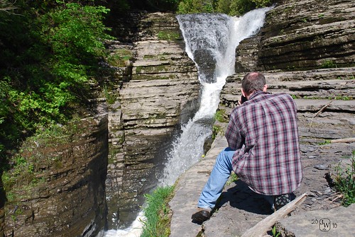
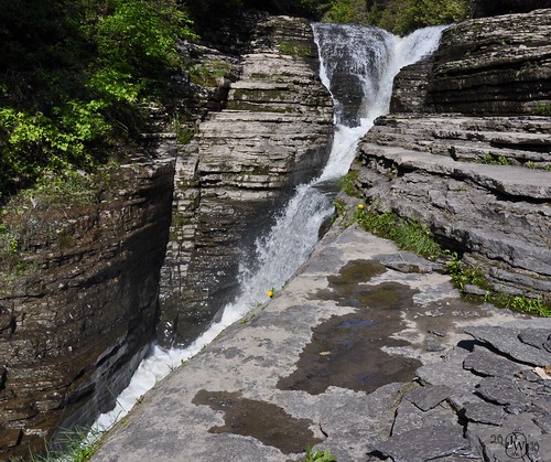
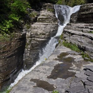
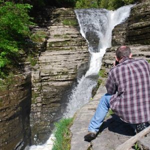
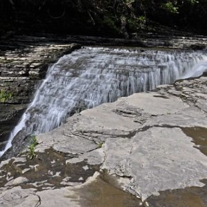
Size/Types: There are three cascades one after another. There is a fissure in the creekbed that the water has worn down, giving these falls a chute-like characteristic in low flow, as the water will gush through this route and drastically change the fall’s appearance. It’s a very striking and unique look to the falls that you don’t see too often. The three falls range in size from 10-15 ft in height and are probably about 40 or so ft tall in total.
Best time to visit: Spring and Fall. Avoid the dry season.
Flow: Moderate. While I would avoid unusually dry summers, like stated above, it may be worth checking out in the lower flow of mid-summer to see the different characteristics the falls takes on in low flow.
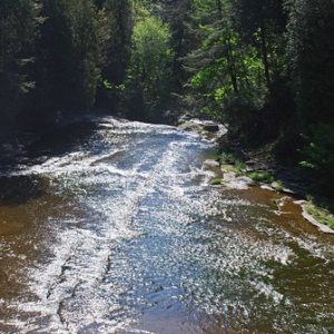
Waterway: Roaring Brook, which has its source in the western part of the town by Haber Pond. It cuts 3 ravines as it heads east to the Black River at East Martinsburg. The Black River travels north to Watertown and empties into Lake Ontario at the Dexter Marsh WMA.
Time: 30 minutes.
Seasons/Hours: The park, which is operated by the town of Martinsburg, is open from Mother’s Day weekend until Columbus Day.
Admission: It’s free to visit for the day. Camping overnight carries a nominal fee ($10-15).
Handicap Accessibility: None.
Pets: Allowed but on a leash or chained to stakes only. Tying to trees is against the rules. Must carry your license.
Accommodations: Trails; picnic tables; playground; campsites (tent and rv); showers; ballfield; pavilions.
Description
AKA: Whittaker Falls
Whitaker Park is a wonderful town park with a beautiful waterfall-filled gorge as its centerpiece. While well-known locally, it’s relatively unheard of for the rest of us. While its 3 waterfalls aren’t super large or picturesque as many other gorges (especially in the Finger Lakes Region) they are quite interesting in appearance. A large natural bedrock fissure runs parallel to the gorge, and thousands of years of water erosion from Roaring Creek has carved it open, resulting in waterfalls that follow a narrow rectangular channel in the rock. Waterfall and geology enthusiasts should definitely make the trip.
The park is kind of out in the middle of nowhere. So, unlike some other destinations, there’s not much to see and do in the area other than the gorge itself. Roaring Brook Falls is just west of here and Whetstone Gulf is to the south. Lyons Falls is even further south. The campsite at Whitaker does serve as a base for visiting a good deal of the area’s waterfalls across multiple days.
History
Martinsburg was originally the town of Turin and the early spelling of the town name was written as “Martinsburgh,” which caused me some headaches finding any info on this place.
The town was named after General Walter Martin (of Massachusetts), who arrived here in 1802, four years prior to Lewis County being formed. He constructed a large stone mansion in the village in 1805. It is listed on the National Register of Historic Places.
The park is named after Daniel Whitaker of Trenton, NY, who settled in Martinsburg in 1818. He owned a mansion and ran a farm adjacent to the park. His family used the gorge as their own private park for a number of years and often invited the community to visit. Upon his death in 1887, he requested of his daughter to grant the land to the town as a park if she were to die without children. She died in 1927, granting the land to the town to become a public park in her father’s name. At some point, the adjacent Peebles property must have also been acquired, either by the Whitakers, or by the town. This property is now the western end of the park.
Whittaker, spelled with two Ts, is sometimes used on maps. This seems to stem from an error in USGS maps. Historic records and maps dating back to the 1850s always spell the family name with one T.

Hiking / Walking Trails
Difficulty: Moderate. A creek-walk that involves slippery surfaces, some climbing, potentially getting wet, and unmarked trails. In wet conditions it becomes difficult.
Markings: A sign or two from the parking area will direct you towards the creek/falls. That’s about it.
Distance: About 2/3 of a mile to see the 3 main falls and go back.
Description: Trails are generally unmarked and not kept. It’s recommended you find your way down to the creek from west of the parking area. The trailheads down are well-defined. Once you reach the creek it becomes a mix of creekwalking and some side trails.
Facing the creek, left (downstream) leads to the 3 main falls. You’ll reach the first one in a 5th of a mile. When you reach the third falls, head back.
Go the other way (upstream) and you’ll be treated to tamer waters and several small drops and rapids. Nothing amazing, but it’s a relaxing and tame creekwalk suited for those not up to climbing downstream.
Map: Interactive.
Whitaker Park Falls Interactive Map
Whitaker Park Falls Media
Videos

Photos by Bremer:


Who to Contact
Whitaker Park
315-286-6487
