Sugar Bush Falls


Location: South of the village of Jordan; Town of Elbridge; Onondaga County; New York.
Maps: Google Map (roadside); Topographic; Interactive map.
GPS Coordinates: Approximate location of the falls: N 43.05360, W 76.46622
Best spot on Valley Dr to view it from: N 43.054139, W 76.465639
Directions: From the village of Skaneateles, head north onto Jordan St (CR-22) and follow it for 2.4 miles. It will become CR-122.
Head right onto Vinegar Hill Rd (CR-142) and follow it for 3 miles to Elbridge.
Here it will become Jordan Rd. Stay on it heading north for 0.7 miles.
You will pass the Maple Grove Cemetery on your right. Just after, turn left onto Crego Rd.
Follow Crego Rd to the end and make a sharp left onto Valley Dr.
You are now heading north on Valley Dr. Keep an eye on your left as you pass the homesteads.
Parking: There is no parking. Do not park in the private driveways. View the falls as you drive by. If you slow down, pull over to the shoulder.
Weather
Information / Accessibility / Accommodations
Note: This waterfall is on private property and is visible from the roadside only. Do not trespass.
Number of falls: 1.
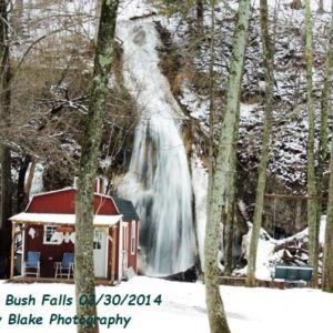
Size/Types: Sugar Bush Falls is an unusual spring-fed ribbon falls over a cone of mineral deposits (Calcareous Tufa). Below the crest of the falls is a small cave. The drop is approximately 50-55 ft in height.
Best time to visit: Year round.
Flow: Low to Moderate.
Waterway: This is a spring fed by a small wetland area above the valley. Agriculture has likely changed the flow of the falls as man-made ponds were constructed in recent decades above the falls. The source of the spring appears to be about a mile to the west. Below the falls is Skaneateles Creek, which comes from Skaneateles Lake to the south and flows north to the Seneca River just northwest of Jordan. The Seneca River flows east to the Oswego River, which then heads north to Lake Ontario.
Time: A minute or so to check it out as you drive by.
Seasons/Hours: Can be seen in daylight hours, year-round.
Accommodations: None. This is private property on a rural road.

Description
Sugar Bush Falls is tucked away in the Skaneateles outlet valley, just south of Jordan and far into private property. We advise that you do not trespass to get close to the falls, which can easily be seen from Valley Drive, and is easy to spot as you pass by. The falls is quite a unique one, consisting of a ribbon cascade, the width of which varies depending on flow, that drains over an organic-looking mineral deposit that bulges out of the cliff face. Below the left side of the large cone-shaped deposit is a cave.
The mineral build-up along the cliff is likely due to the water’s source, which is said to be a spring uphill. Saturated with calcium from the limestone bedrock, it deposits crystals over time, likely hundreds or thousands of years.
The striking shape of the falls with bright and thin ribbon-like cascades down it, as well as its significant height of 50+ feet, makes it easy to spot as you drive by.
History
Settlers first arrived in the Elbridge area in 1793. The town of Elbridge was organized in 1829 from parts of the town of Camillus. Early farmers used the abundance of “plaster formations” (or gypsum) in the area as fertilizer for their crops. This mineral is what forms the deposits found at the falls.
The home near the falls was once a hydroelectric power facility for the village of Jordan and the creek was dammed for some time. Dates and names are unknown. Let me know if you have any details on this.
A local legend mentions the killing of one of the last black bears of the region taking place in the cave behind the falls. Some credible sources tell of this cave being located a mile south of the village of Elbridge, where Robert Fulton and William Stevens once killed bear. There is no mention of it being the “last one” in this particular version of the story.
The name Sugar Bush Falls comes from the landowner who would make maple syrup in the shed next to the falls.
Sugar Bush Falls Interactive Map
Sugar Bush Falls Media
Videos
Nothing yet.


Who to Contact
No one. It’s private property.

