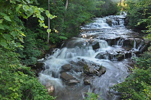
Stockbridge Falls

Location: Southwest of the village of Munnsville; Town of Stockbridge; Madison County; New York.
Maps: Google Map; Topographic; Interactive map.
GPS Coordinates: Viewing from the road (N 42.95124 / W 75.60407)
Directions: There are countless ways to get here.
From the north: Work your way to Oneida, and then take NY-46S to Munnsville. Head south on Main St in Munnsville for about a mile.
Turn right onto Pratts Rd and follow for 0.6 mile.
Turn right onto Stockbridge Falls Rd (CR-32) and follow for 0.8 mile.
Turn left onto Falls Rd. Drive slow. The falls will be on both sides of the creek when you pass over the bridge.
From the south: From US-20 at Pine Woods, turn onto NY-46N (Pratts Rd) and follow it for 3.5 miles.
Turn left onto Streeter Rd, follow for 0.4 mile.
Turn left onto Falls Rd.
After 1.2 miles, Falls Rd will cross over the creek and the falls will be on both sides.
Use Google Maps.
Parking: Just north of the bridge is a very small pullover area. There’s barely room for two cars. Don’t park in any private driveways.
Weather
Information / Accessibility / Accommodations
Number of falls: Depends on who you ask. I would consider this to be one long step cascade. Many people classify the steps into individual falls. There are many more of these steps than you will be able to see from the road. So it’s either one long waterfall, or about 6-8 smaller waterfalls (that you can see).
Size/Types: This is one really long step cascade spanning both sides of the bridge. While the steps are uneven, it really does look like a waterfall staircase. What you can see upstream is about 6 of these steps, the smallest being about 3 ft, and the largest approaching 15 ft. Downstream you can see the tops of several more. This stretch of steps goes through the private property downstream all the way to Jones Rd. It’s possibly a 100ft descent in total.
Best time to visit: Daylight hours, year-round.
Flow: Consistent. It does lighten up by summer, which may mean photos will look a bit uneven, but it’s usually flowing some.
Waterway: Oneida Creek. Its source is several miles to the west at Peterboro Swamp. It passes through a heavy agricultural area as it makes its way down Munnsville West Hill, cutting Stockbridge Falls, along the way, and into the Stockbridge Valley toward Munnsville. It heads north picking up flow from dozens of tributaries in the valley, and is pretty large by the time it gets to the City of Oneida 9 miles north of here. From Oneida, it heads northwest 5.5 miles to Oneida Lake at Verona Beach State Park.
Time: It’s a roadside falls. 5 minutes is all you need.
Seasons/Hours: The road is open all year. It’s very narrow, so in snow, it may be tough for pedestrians and cars to share the space.
Admission: Free.
Handicap Accessibility: The road is technically wheelchair accessible, but it’s very narrow. Watch out for traffic.
Pets: Pets need to be on a leash in public.
Accommodations: Eateries and shops in nearby Munnsville.
Description
Despite being tucked within a wooded sliver of view from a narrow rural road, not available for hiking or swimming, and surrounded by private land, Stockbridge Falls is one of the more picturesque falls in the region. With homes, yards, playgrounds, and automobiles all around, you would never guess that from a photo. The woods isolate this fantastically long series of cascades on Oneida Creek, making it look like it can be found deep in a mountain forest.
A great definition of a staircase cascade, it’s comprised of at least 8 drops, and truly a treat for the eyes. There’s more to this stretch of the Oneida as it enters the valley from Munnsville’s western hills, but alas, the rest of it is on private property and not accessible. Despite that, what you can see from the road is well worth the quick stop.
History
The Oneidas inhabited the land long before European settlers. Around the time Europeans started exploring the land, the region’s Oneidas migrated from a large village in Stockbridge to Oneida Castle in the north. When the Tuscaroras become the 6th nation of the Iroquois, a colony of them settled at the former Oneida village in Stockbridge.
The name Stockbridge, at least this instance of it, comes from a local native tribe, who settled here from Stockbridge, Massachusetts. They were originally a part of the Mohicans who migrated to western Mass. prior to the Revolutionary War. There, they became Christianized. In the late 18th, early 19th centuries, they migrated back.
The first settlers in the town of Stockbridge were Nathan Edson and family, who located in the southwest near the falls.
The town of Stockbridge was separated from the towns of Smithfield and Lenox in 1836, and those were originally part of Oneida County.
Hiking / Walking Trails
Difficulty: Easy.
Markings: Stay on Falls Rd.
Distance: A few dozen feet.
Description: This is a roadside falls only. There are no hidden trails, no creekwalks, no better views. This is it. The land around it is private property.
Park just north of the bridge. Walk to the bridge to see the falls. Walk back to the car. Be mindful of traffic because this bridge is pretty narrow and there is no shoulder.
Note: the map in Scott E. Brown’s book “New York Waterfalls” is erroneous and shows Jones Rd for viewing the falls. It should be Falls Rd. Apparently many people are showing up on Jones Rd, parking in a private lot, and walking into people’s yards because of this.
Map: Interactive.
Stockbridge Falls Interactive Map
Stockbridge Falls Media
Videos

Who to Contact
No contact information.


