Judds Falls (Cherry Valley)


Location: North of the village of Cherry Valley; Town of Cherry Valley; Otsego County; New York
Maps: Google Map; Topographic; Interactive map.
GPS Coordinates:
- Judds Falls: N 42.82179 / W 74.73672
- Parking area: N 42.82196 / W 74.73495
Directions: From Albany…
- Head west on US-20 for 32 miles to Cherry Valley.
- Take the NY-166 exit toward Cherry Valley.
- Take the NY-166 S route by turning left, and be prepared to take an immediate right into the parking area.
Parking: A gravel parking area near the crest of the falls off of NY-166. There’s room for 2 or 3 cars. Alternate parking is just south of here at the intersection of Salt Springville Rd and NY-166. It has space for about 2 cars.
Weather
Information / Accessibility / Accommodations
Number of falls: 1
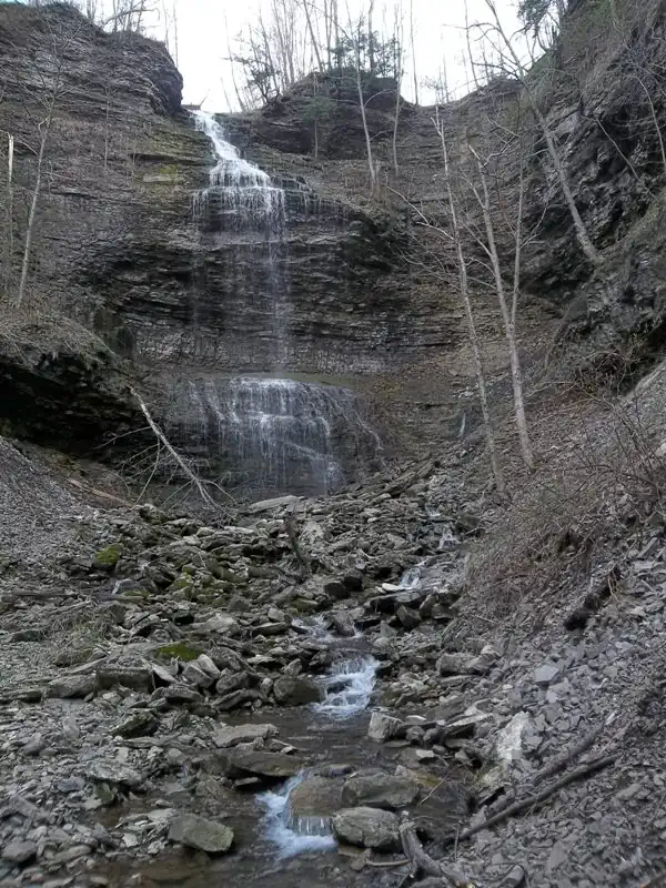
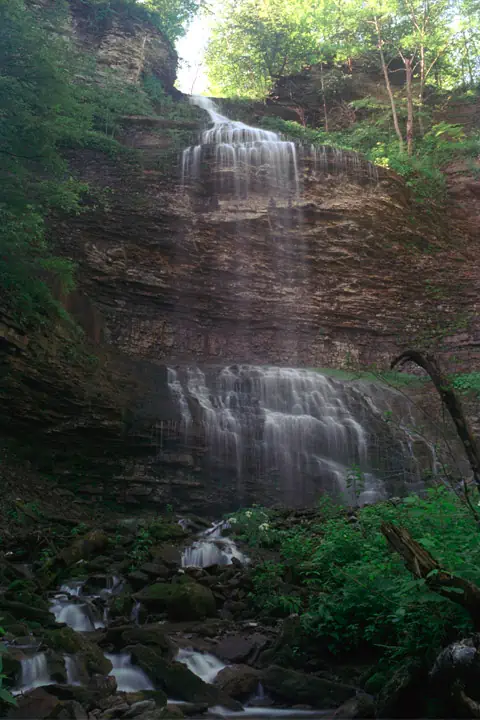
Size/Types: A 135-ft cascade that starts out narrow, fanning out as it cascades down the first 3rd of its length. It then freefalls in a beautiful thin rectangular curtain, and then lands on a steep irregular shelf, cascading the rest of the way down into a shallow pool.
Best time to visit: Early spring to see it roar. Late spring and after moderate rain in the fall to be able to trek upstream from the bottom.
Flow: While not a large creek by any means, the falls can be striking, even in low flow. Still, you want to avoid dry summers.
Waterway: Canajoharie Creek, which has its origins on the south side of US-20 less than a mile away. It drains water from the valley here so it does pick up some considerable flow in such a short distance. The creek flows under the highway and then emerges just before the falls. The gorge here is about 150 ft deep and the creek flows north through it into Montgomery County where it turns west, then north, through Canajoharie, and then empties into the Mohawk River. The Mohawk then takes the water east towards Albany and into the Hudson. The Hudson then flows south to New York City and the Atlantic Ocean.
Time: It takes a few minutes to walk to the crest of the falls from the parking area. If you want to hike down the gorge then up to the base, plan for over an hour.
Seasons/Hours: You can spot the falls from the crest year-round. While this natural area doesn’t technically close, the trail is not maintained and weather may make it risky. Leave yourself enough daylight, to avoid getting lost down there in the dark, and check the weather for incoming storms to avoid flash floods.
Admission: Free.
Handicap Accessibility: None. Not recommended for hikers with accessibility needs.
Pets: No rules are posted, but this is a risky hike not suitable for pets, nor is it cool or appreciated for other hikers trying to pass on the narrow and risky trail.
Accommodations: Just a trail. Head south on CR-166 into Cherry Valley for some restaurants and shops.
Description
Commonly known as Judd Falls, the USGS has it listed as Judds Falls. The original name, Tekaharawa and sometimes Tekaharaw or Tekaharana, is a Native American name meaning “Place of High Waters.”
Judd Falls in Cherry Valley, NY is a breathtaking natural wonder that has captured the hearts and imaginations of visitors for generations. Located in the heart of upstate New York, northeast of Cooperstown, this stunning 135-ft tall waterfall is surrounded by steep cliffs, lush forests and rolling hills overlooking the Mohawk Valley.
The falls themselves are an awe-inspiring sight to behold, with water from Canajoharie Creek cascading down a steep rock face into a deep pool below in the cool, shadowy gorge over 100 ft below the sights and sounds of civilization. Visitors can experience the falls from its crest near US-20 or hike down to the edge of the plunge pool and feel the mist of the waterfall on their faces. The area around the falls is home to an abundance of wildlife, as well as historic sites from America’s colonial past.

One of the unique features of Judd Falls is the fact that it is located within a steep gorge at the fringe of the Helderberg Escarpment, known for Howes Caverns and Knox Cave, as well as being a source for many salt and sulphur springs, which can be found along the northwest side of the gorge (and you may be able to smell them from time to time). Canajoharie Creek starts not too far from here, and doesn’t get a chance to pick up much flow before entering the gorge. Still, the gentle waters fall from such a great height, and tens of thousands of years of floods have carved out a beautiful notch in the escarpment. This waterfall, one of the tallest in the state, is its centerpiece.
While not within an official park or preserve, the land does seem to be public space, with perhaps the falls landing within the ownership of the state highway department. There is a trail that leads down to the creek, for those who want to walk up to the base of the falls. It is not kept, and tends to overgrow and change over time. A 32-year-old woman fell over 100ft down the gorge in September of 2022. The rescuers had to hike a mile down through woods to reach her. She sustained multiple injuries and made national news. Be safe, proceed at your own risk, and read some Waterfall Exploration Safety Tips before you take the trek.
History
Prior to white settlers, Cherry Valley was home to the Mohawk and Seneca tribes. What is now US-20 was an important pathway for Native Americans in NY, and early settlements in the area sprung up along this trail. The area was ideal for farming, and the fertile soil and abundant water supply made it an attractive location for settlers. One of the early settlers was John Lindsay, a Scot who served as a naval officer in New York City and then served as Sheriff of Albany, acquiring parcels of land in Cherry Valley at the time. By 1939, he had acquired the whole tract. Upon retiring as sheriff, he moved and settled there with his family, pursuing a business in trade with the Iroquois. The settlement became known as Lindsay’s Bush. The village was named Cherry Valley by Reverend Dunlop after the wild cherry trees that grew in the area, which were a valuable commodity at the time. The name became official when the village was incorporated in 1812.
Oliver Judd was a descendant of Deacon Thomas Judd, who came from Cambridge, England to Hartford, Connecticut and then moved to Farmington, NY in 1644. Oliver was born in Hartford on June 9, 1782 and learned blacksmithing, serving as an apprentice to his uncle. He married in 1804 and moved with his wife to Cherry Valley and set up shop. Among the products he manufactured were sleigh bells and other miscellaneous brass work, jewelry, clocks, and saddlery. He supplied American troops with harnesses and saddlery trimming during the War of 1812. In 1816, he was elected magistrate, a position he held for 21 years. In 1823, he established an iron foundry along the creek in the village, which then moved to a larger facility on the corner of Main and Wall Streets in 1850 (now the American Legion building, or “Star Theater”). He served on the state legislature in 1816 and again in 1825, and for a time served as postmaster. This is what people did before television. Known for being sober his whole life, he abolished drinking from his foundry employees. This temperance trait was passed on to his children, who were very active in the temperance movement of the early 20th century. His son took over the foundry business.

While several websites state that Judd’s foundry was located at the falls, I could not find any evidence of this. After poring over records and maps from the time, we can see the property next to the falls was the Judd household, passing from Oliver to his son Edwin. Maps have the falls listed as Tekeharana well past Oliver’s death and into the 20th century. The falls is likely named after Edwin or his successors due to the residence. Next to the residence was School #5, a place Oliver was once very involved in and supported. The foundation of the school can be seen near the parking area.
Hiking / Walking Trails
Difficulty: Easy to see the crest of the falls, which is a short hike from the parking area. Getting to the base of the falls, which is up to you, elevates this hike to moderately difficult.
Markings: None. Study the maps carefully and use your best judgement.
Distance: A few hundred feet to get to the gorge rim and see the falls. About a mile to the base of the falls and back.
Description: Note that this trail changes. Sometimes it’s overgrown and sometimes some alternate paths become the main path. Proceed at your own risk and hike safely.
- From the parking area head west (green path on the map below) towards the gorge and paralleling Salt Spring Road. You will eventually reach the gorge where the falls begins.
- From there you should be able to pick up a trail that runs north along the gorge (yellow). Along the way you will pass a clearing along the cliff where you will be able to catch a glimpse of the top half of falls. Keep going.
- At about a quarter mile there will be a switchback that crosses over a seasonal creek, turning you west and then down into the Canajoharie creek bed.
- Hike upstream to get to the falls.
- Go back the way you came.
Map: Interactive.

Judds Falls Interactive Map
Judds Falls Media
Judds Falls (Cherry Valley) Videos

Contributor Photos & Art
At this time I have not been able to get out to this site and photograph yet. In the meantime, those with suitable photos or original works of art, who would like to be featured here, please contact me. Photos, paintings, and illustrations would be subject to quality review, and not all will be accepted. Your work can be accompanied by a link to your site/store/instagram.
Leading Video by Cloudclips7
Photos by L_G_D


Interesting Stuff
Cherry Valley Massacre
A monument in the Cherry Valley Historical Cemetery (on Alden St in the village) commemorates the Cherry Valley Massacre, an attack by British and Iroquois forces on a fort and the town of Cherry Valley on November 11, 1778, during the American Revolutionary War. It has been described as one of the most horrific frontier massacres of the war.
A mixed force of Loyalists, British soldiers, Senecas, and Mohawks, under the command of Captain Walter Butler, descended on Cherry Valley, whose defenders, despite warnings, were unprepared for the attack. During the raid, the Seneca in particular targeted non-combatants, and reports state that 30 such individuals were killed, in addition to a number of armed defenders.
The massacre was the result of a series of conflicts that began in the summer of 1778, when the British sent a force of Loyalists and Iroquois to raid the Mohawk Valley. The raiders were successful in destroying several villages and killing dozens of people. In response, the Americans launched a series of raids on Iroquois villages, destroying them and killing hundreds of people.
![[Settlers of Cherry Valley Fleeing from Brant (Cherry Valley, N.Y., Nov. 1778. Tories and Indians led by Walter N. Butler and Joseph Brant raided village and massacred more than 40 people)]](https://nyfalls.com/wp-content/uploads/2023/04/cherry-valley-massacre.webp)
The Cherry Valley Massacre was a reprisal for the American raids on Iroquois villages. It is likely that the Iroquois forces were seeking revenge for the deaths of their people. The massacre was a brutal and bloody act of revenge, and it shocked the American public.
The massacre had a profound impact on the American Revolutionary War. It led to a wave of anti-British sentiment in the American colonies, and it helped to galvanize support for the war effort. The massacre also led to a series of reprisals by the Americans on Iroquois villages, which further escalated the violence of the war. It was also a key factor leading up to the Clinton-Sullivan Campaign of 1779, which was a coordinated effort by General George Washington to eliminate the Iroquois Nation, leading to the deaths of over 1000 Iroquois and the migration of countless others.
The Scalping of Lieutenant Wormuth
A monument and marker on VanDerwerker Rd, north of the falls, marks the location where Lt. Matthew Wormuth (sometimes written as Wormwood) was killed and scalped by his (I assume former) friend Joseph Brant (or, likely by men under Brant’s command) in May of 1778. A large boulder is said to be the site of the killing and the place where the body was found. An excerpt from “The Frontiersmen of New York: Showing Customs of the Indians, Vicissitudes of the Pioneer White Settlers, and Border Strife in Two Wars · Volume 2” by Jeptha Root Simms describes the situation, but is not a first-hand account. Most documents of this event stem from the publishings of William W. Campbell:
Lieut Matthew Wormuth, a promising young officer of Col Klock’s regiment, residing in Palatine, accompanied by Peter Sittz, a neighbor, had been sent by his colonel with dispatches for the garrison at Cherry Valley. Brant, who it is believed witnessed the arrival of those messengers, moved down and concealed a part of his men near the road by which they must return, to await that event. Nearly two miles from the fort, the road passed a deep and dismal gorge, called by the Mohawks Te-ka-har-a-wa, the signification of which is unknown At the upper end of the gorge, was a large rock, shaded by forest trees, near to which the enemy were concealed. As the horsemen approached the rock, says Campbell, they were hailed and ordered to stop, but instead of doing so, they put spurs to their horses. A volley of musketry brought down the young subaltern mortally wounded, and killed the horse of Sittz, who was captured. The horse of the former returned to the fort, and his bloody saddle revealed its owner’s probable fate. Brant, in his concealment, supposed from his military dress, he was a continental officer, but on running up to him, and discovering a former personal friend, he expressed his sincere regret for his fate, and asked him if he thought his wounds were mortal—saying if he believed he could survive them he would have him tenderly cared for. His reply was that he could not live; wherupon he was dispatched and scalped, but not by Brant in person. William H Seeber, now 1880 living at the age of 89—who is from a patriotic family three members of which got a lasting furlough at Oriskany—and who has ever resided in a town adjoining Cherry Valley, assured me that he had always heard this story from Revolutionary men as here related. If Brant “lamented his death,” it can hardly be supposed he would with his own hand have dispatched him.
He was found the next morning by a party from the fort to which he was borne, and a dispatch sent to Col. Klock announcing the fate of his own messengers of the day before. Col. Klock came up with a body of militia, and with him Peter Wormuth, father of the Lieutenant, who with a sad heart—for he was his only surviving son took him to his residence in Palatine. He dwelt in a small stone house, which in its ruins I visited in 1856. It stood on the farm of the late Reuben Lipe, between the present farm house and the river, where the road ran at an early day. Lieut Wormuth was buried from this house; just where cannot be told, but it is said to have been near the Palatine stone church. He left a young widow, who afterwards became the wife of Maj. John Frey.
TLDR: This was the Revolutionary War. Joseph Brant, a Mohawk military and political leader allied with the British. Brant and his troops were waiting in the woods behind a boulder off the road. They saw two American soldiers on horseback, ordered them to stop. They didn’t stop, so Brant and his soldiers attacked. Wormuth was mortally wounded. Brant realized that this was his old friend. Brant asked Warmouth if he could survive, and if so would be cared for. Wormuth said he was done, and was finished off and scalped, likely by one of Brant’s men. The guy who published the story back in 1831 spells Wormuth as Wormwood and for 100 years maps of Cherry Valley have “Wormwood Rock” on it.
Who to Contact
Village of Cherry Valley
815-332-3442
