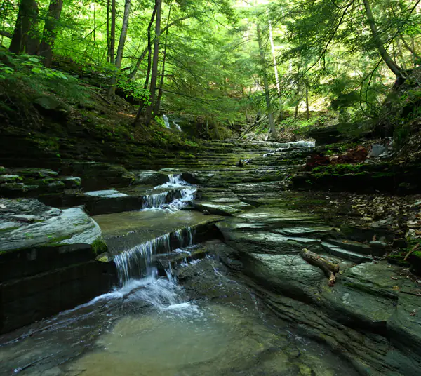
IBM Glen

Location: Just west of the village of Johnson City and city of Binghamton, in the town of Union, Broome County, New York
Maps: Google Map; Topographic; Trail map; Interactive map.
GPS Coordinates:
- Waterfall: N 42.12955 / W 75.99865
- Parking lot: N 42.13373 / W 76.00257
Directions: From US-81 in Binghamton, exit to NY-17 west and follow it for about 4 miles to CR-70N. Turn left onto Harry L Dr. Then take a right onto Oakdale Rd (CR-65). After about 1/3rd of a mile turn left onto Robinson Hill Rd. Follow this road for about 2 miles and look for a white sign that says IBM Glen. Pull into the lot.
Parking: The parking area off of Robinson Hill Road has spaces for about 25 cars. Formerly parking was through the Traditions at the Glen golf resort, but no more. Use the dedicated lot.
Weather
Information / Accessibility / Accommodations
Number of falls: 1
Size/Types: A cascade of about 8-12 ft high and a few small drops below.
Best time to visit: Spring or after heavy rain.
Flow: Low to moderate. Tends to dry up in late summer.
Waterway: This unnamed stream runs just over a mile south to where it joins with the Susquehanna River. The Susquehanna empties into the Chesapeake Bay at Perryville and Havre de Grace, Maryland.
Time: About a half hour to see the falls, an hour more to hike the other trails.
Seasons/Hours: Daily, from dawn to dusk.
Admission: Free.
Handicap Accessibility: Trails are narrow dirt paths and not accessible by wheelchair.
Pets: Must be on a leash.
Accommodations: Trails, signage. There are shopping malls/plazas nearby.
Description
IBM Glen is a beautiful 200 acre nature preserve located just between Endwell and Johnson City in the Southern Tier. Set in a mature forest, with some of the oldest trees in the county, the small glen has 2 miles of winding trails, beautiful stone bridges, and a picturesque single waterfall.
Once owned by IBM and a part of their employee country club, the land was acquired by the Waterman Conservation Education Center, and is now open to the public to enjoy.
History
The property was first settled by Oliver Crocker of Massachusetts who built a home below the glen. In the 1930s IBM purchased the property and built it into a recreation resort for employees. Lounges, restaurants, pools, tennis courts, gymnasium, and golf course were constructed alongside the old brick home, with several of the facility’s buildings connected to the original structure. All IBM employees of the region were automatically members and could enjoy the facilities for a couple of bucks, regardless of class.
Sometime in the 1940’s Thomas and Jeanette Watson helped facilitate the construction of a series of trails and stone bridges in the glen, which gave the community access to this beautiful natural space.
In the 1990s IBM no longer had an interest in operating the facility and sold it piece by piece. The golf course is now operated by Traditions Hotel & Spa. The old homestead and some other buildings were turned over to some venue management operations and even a day/summer care business. The glen was to be logged.
Through the efforts of local conservationists led by Barbara and Alan Jones, the glen was saved from destruction and in 2004 the Waterman Conservation Education Center took over ownership.

Hiking / Walking Trails
Difficulty: Easy to Difficult. It really depends on what trails you take. The Creek Trail is probably the most difficult path to take and you can avoid it and still get to the falls. There are slopes, but nothing drastic on the main trails. It’s easy to get lost here, but it’s only 2 miles of trails and you just need to remember the parking lot is on the Yellow Trail/Wildflower Lane.
Markings: Color blazes for the 3 main trails. There are some unmarked trails.
Distance: Direct route to the falls is less than a half-mile one way. A complete hike on every trail is about 2 miles.
Description: From the parking area, head south on the yellow trail. Pass the two junctions with the red trail and stay on the yellow path. You will approach the creek at some point. It should be a dry crossing unless you are visiting after heavy rain. After the crossing the trail heads south alongside the creek. You will pass a shelter about half-way down to the falls. At the junction after this, head downhill a ways to the waterfall and stone bridge.
Alternatively, when you reach the second junction with the Red trail, go red. A bit south of this junction is a switchback trail leading to the creek. You can then cross the creek to a small trail to the falls or walk down the creek itself.
Map: Trail map; Interactive.
IBM Glen Interactive Map
IBM Glen Media

Contributor Photos & Artwork
At this time I have not been able to get out to this site and photograph yet. In the meantime, those with suitable photos or original works of art, that would like to be featured here, please contact me. Photos, paintings, and illustrations would be subject to quality review, and not all will be accepted. Your work can be accompanied by a link to your site/store/insta.
Interesting Stuff
Abandoned IBM Country Club
The Country Club that used to own the property, while now re-opened as a resort, stood abandoned for decades. Some urban explorers have documented their trespass on the property.

Who to Contact
Waterman Conservation Center
watermancenter.org/contact


