
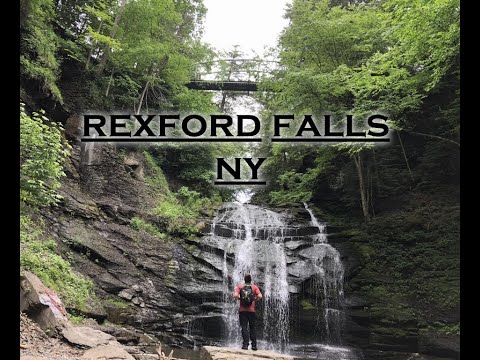
Rexford Falls


Location: East of the village of Sherburne; Town of Sherburne; Chenango County; New York.
Maps: Google Map; Topographic; Interactive map.
GPS: Rexford Falls: (N 42.67887 / W 75.47131)
Parking area on the north: (N 42.67969 / W 75.47170)
Pullover on the south: (N 42.67969 / W 75.47170)
Directions: From nearby Sherburne: Take E State St (NY-80) east about a mile outside the village. Look for the sign on the right that says Rexford Falls. The park entrance is a U-shaped driveway.
Google Maps will get you there.
If you want to hike into the gorge, continue past the aforementioned park entrance and turn right onto Rexford Falls Rd. It will hook back toward the park on the other side of the gorge. Look for a small dirt pullover area on the right.
Parking: The park’s official parking area is a U-shaped driveway off of NY-80. There’s room for about 15 cars to park along it.
The dirt pullover on Rexford Falls Rd will take a handful of cars. It gets you closer to the trail leading down to the gorge, but it’s not like the other lot and too from it. The official lot is just fine.
Weather
Information / Accessibility / Accommodations
Number of falls: 1.
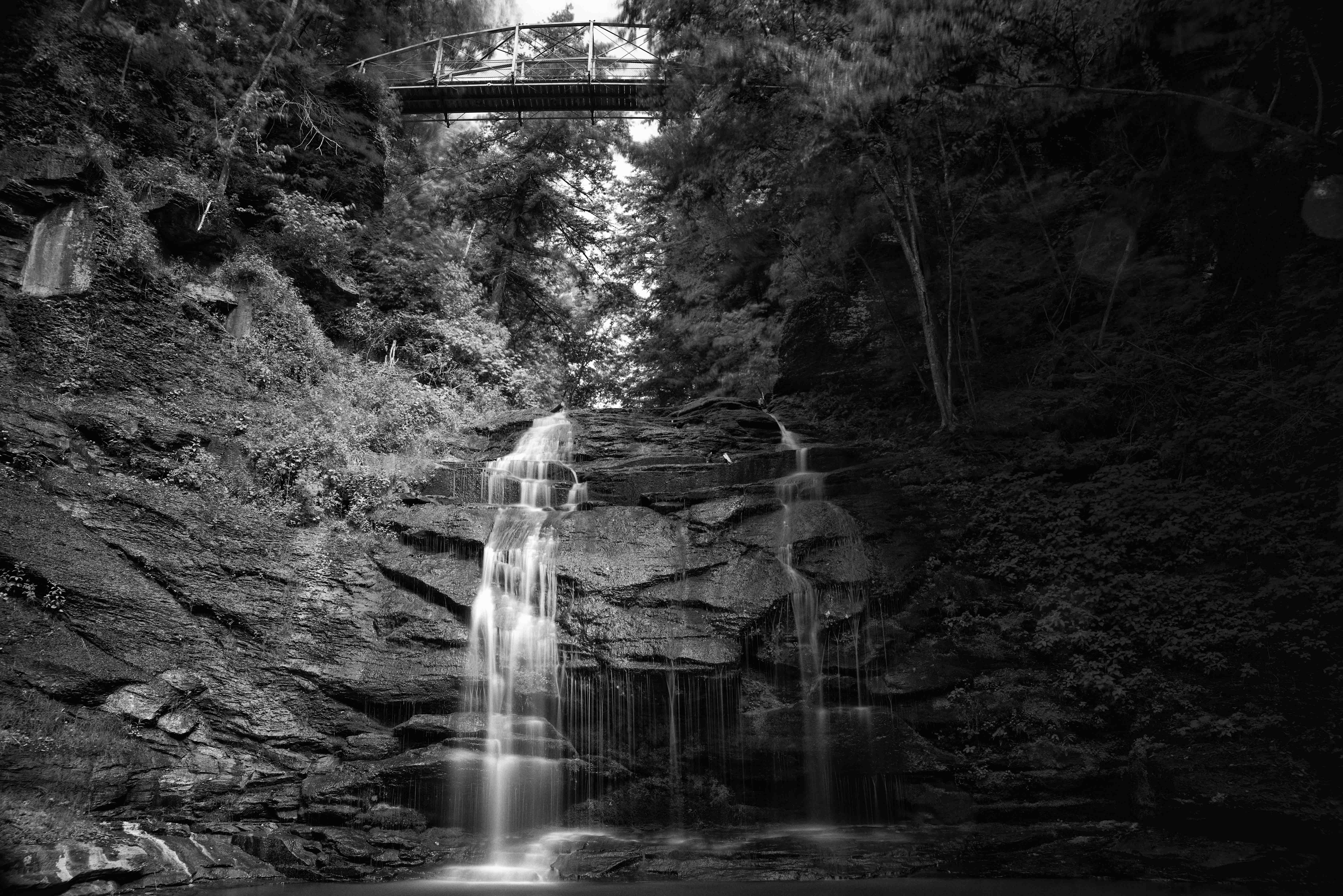
Size/Types: A 75 ft tall cascade under a historic footbridge. A nice wading pool forms at the base of the falls.
Best time to visit: Year-round. Avoid late dry summers.
Flow: Moderate.
Waterway: Mad Brook, which has its source in the hills 2.5 miles northeast of here. It slows through two millponds before reaching Rexford Falls. It reaches the village of Sherburne in the valley and turns south just before its confluence with the Chenango River. The Chenango flows south to Binghamton where it empties into the Susquehanna River.
Time: 30 minutes to see the falls from above and below.
Seasons/Hours: Open daylight hours, year-round.
Admission: Free.
Handicap Accessibility: Unfortunately while the bridge could be accessible, there is no paved path over the lawn between the parking area and the bridge.
Pets: On a leash, please.
Accommodations: Only a trail. Sherburne, to the east has a few eateries and shops.
Description
Hidden away in a small gorge in northeast Chenango county is this beautiful 75 ft cascade and historic footbridge. A small park, donated to the town of Sherburne by the falls’ namesake, allows visitors easy access to the falls from 30ft above. For the more adventurous, a trail tucked away on the south side of Mad Brook leads down into the gorge, and a short creekwalk upstream leads right to the base of the falls and its refreshing pool.
History
The town of Sherburne was formed from the town of Paris in 1795. In 1808, the town of Spafford (originally Smyrna) spun off, and in 1852, the town grew by annexing a part of New Berlin. The name may have come from early settlers who frequently sang the 1785 song by New Haven, Connecticut composer Daniel Read.
The first settlers arrived in the town in 1792, the very first of which were Abraham Raymond and family. Nathaniel Gray, Newcomb Raymond, Elijah Gray, Eleazer Lathrop, Josiah Lathrop, James Raymond, Joel Hatch, John Gray, Jr., Abraham Raymond, Timothy Hatch, Cornelius Clerk, Joel Northrop, John Lathrop, John Gray, John Hibbard, and Ezra Lathrop settled in 1793.
A sawmill was constructed in the gorge east of Sherburne Village, about a half-mile below the Rexford Falls. Another mill was constructed at the falls in the 1800s by John Gilmore. Records have mentioned that a spout in the roof of the mill fed water to the wheel (something quite unusual). A road led down into the gorge and to the mill from the north side of the gorge. Maps from the time show the falls name as “Sherburne Falls.”
Sherburne village was incorporated in 1830.
A sulphur spring just below the falls was used for the treatment of skin diseases, dating back into the 1900s. The Shelburne Spring House, a clinical hotel, was built just upstream from the falls in 1876 by Charles Reynolds.
Benjamin Rexford moved here from Middle Granville, Mass., in February, 1804. The falls is now named after his son, Nelson C. Rexford, who gave the township the land around the falls on Feb 15, 1876.
The footbridge above the falls was constructed by an unknown person(s) in 1877. It is a metal bowstring truss bridge. It was rehabilitated in 2006, at a cost of $40,000.
Hiking / Walking Trails
Difficulty: Easy to see the falls from the footbridge. Getting down into the gorge poses a little more challenging.
Markings: None.
Distance: About 100 feet to the bridge above the falls. Several hundred feet more to cross the bridge and walk the path to the gorge below.
Description: From the parking area off of NY-80 walk across the lawn toward the tree line and footbridge. Head onto the bridge and look down at the falls. This view makes the falls look misleadingly small.
Cross the bridge to the wooded side and go immediately right, keeping the fence on your right. You will reach a point at which there is a gap in the fence and a trail leading beyond it. Follow that trail down into the gorge.
Then creekwalk back upstream to the falls.
Map: Interactive.
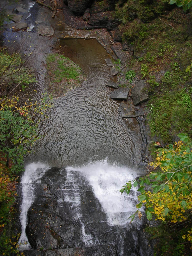
Rexford Falls photo by Doug Kerr. (CC BY-SA 2.0)
Rexford Falls Interactive Map
Rexford Falls Media
Videos
Contributor Photos & Art
This photo was posted to the NYFalls Talk message board by Wells H (check out his portfolio here)
Who to Contact
Town of Sherburne
607-674-4481
