
Decker Creek and Montville Falls


Note: Access to Deckertown and Montville Falls is restricted. All adjacent property, including the cemetery is private property. I have been notified that the Falls themselves are also on private land (although I have not personally verified this). When I traveled to the site over 5 years ago, I ran across zero signage. I haven’t checked since, but things change.. As I always say, if you trespass, it’s on you, and you deal with all legal responsibilities. This information is here for informational purposes only.
Location: Located in the small hamlet of Montville, barely east of Moravia, Cayuga County, New York.
Maps: Google Map; Topographic; Interactive.
GPS coordinates:
- Montville Falls: N 42.71511 / W 76.40860
- Decker Creek Falls: N 42.71703 / W 76.40923
Or use Google Directions.
Directions: From Auburn, head south on either 38 or 38A to Moravia, where they connect. Somewhere around here you may be able to find a place to park.
Or use Google Directions.
Parking: Up to you to find a place that is publicly accessible. There are no known lots at this time and we are not 100% sure about what is and isn’t publicly accessible.
Weather
Information / Accessibility / Accommodations
NOTE:
Montville Falls: Previous access was from a property near the old mill downstream off of Rt 38. NYFalls.com members have reported that landowners at this location have denied permission to property along the creek.
Number of falls: 3
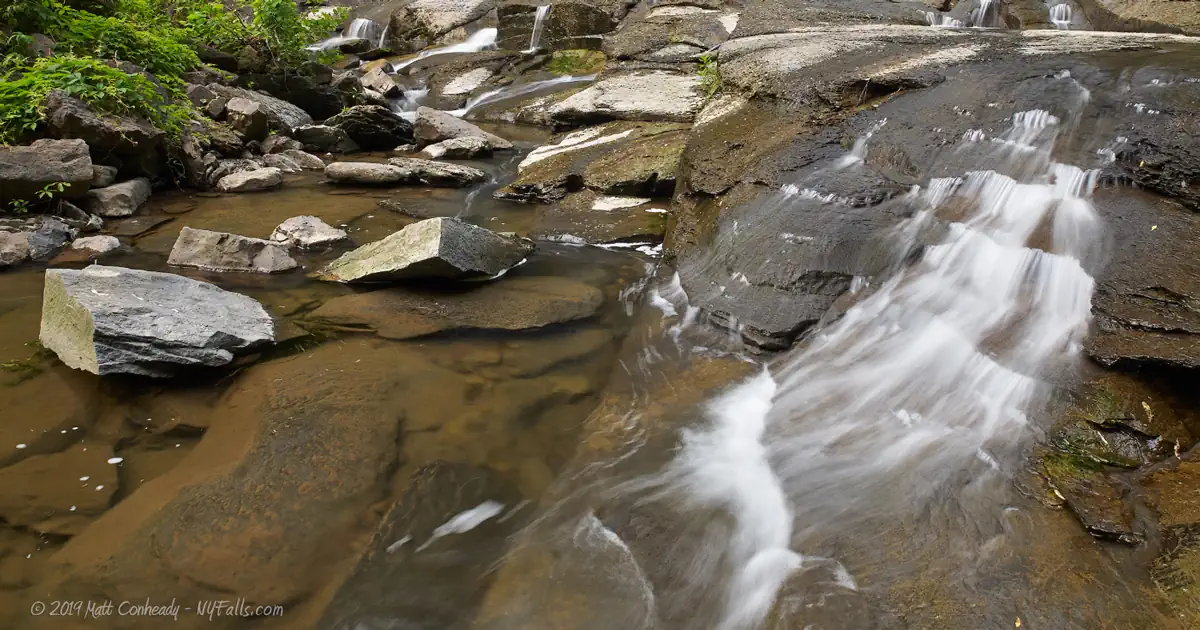
Size/Types: Decker Creek has 9 ft and 6 ft cascades, one right after the other.
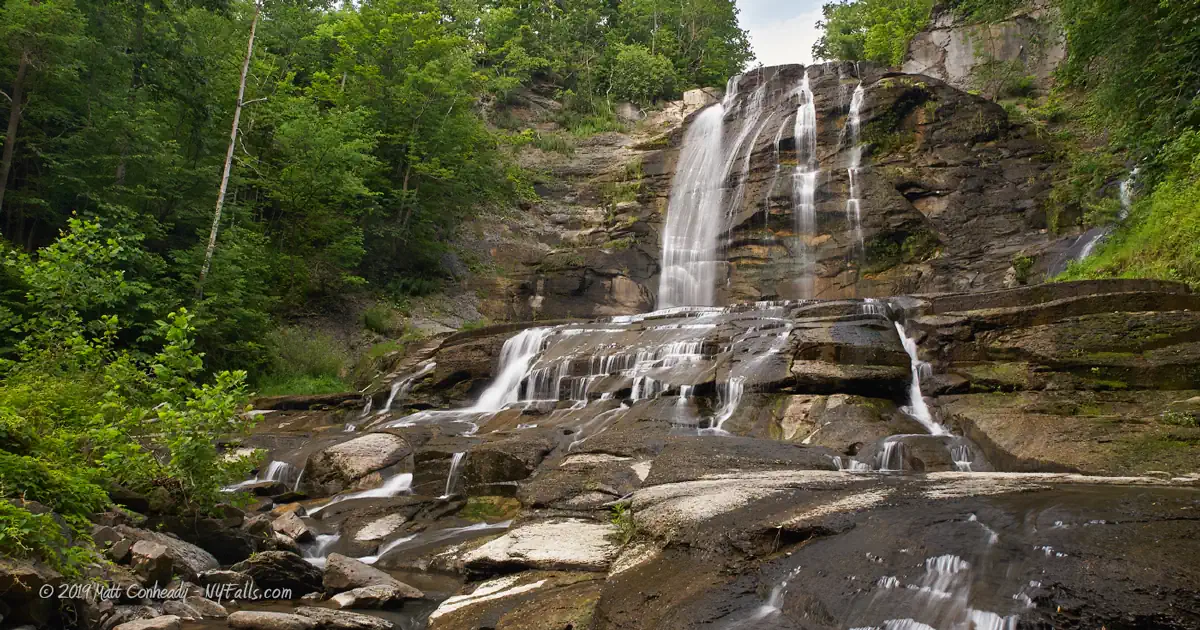
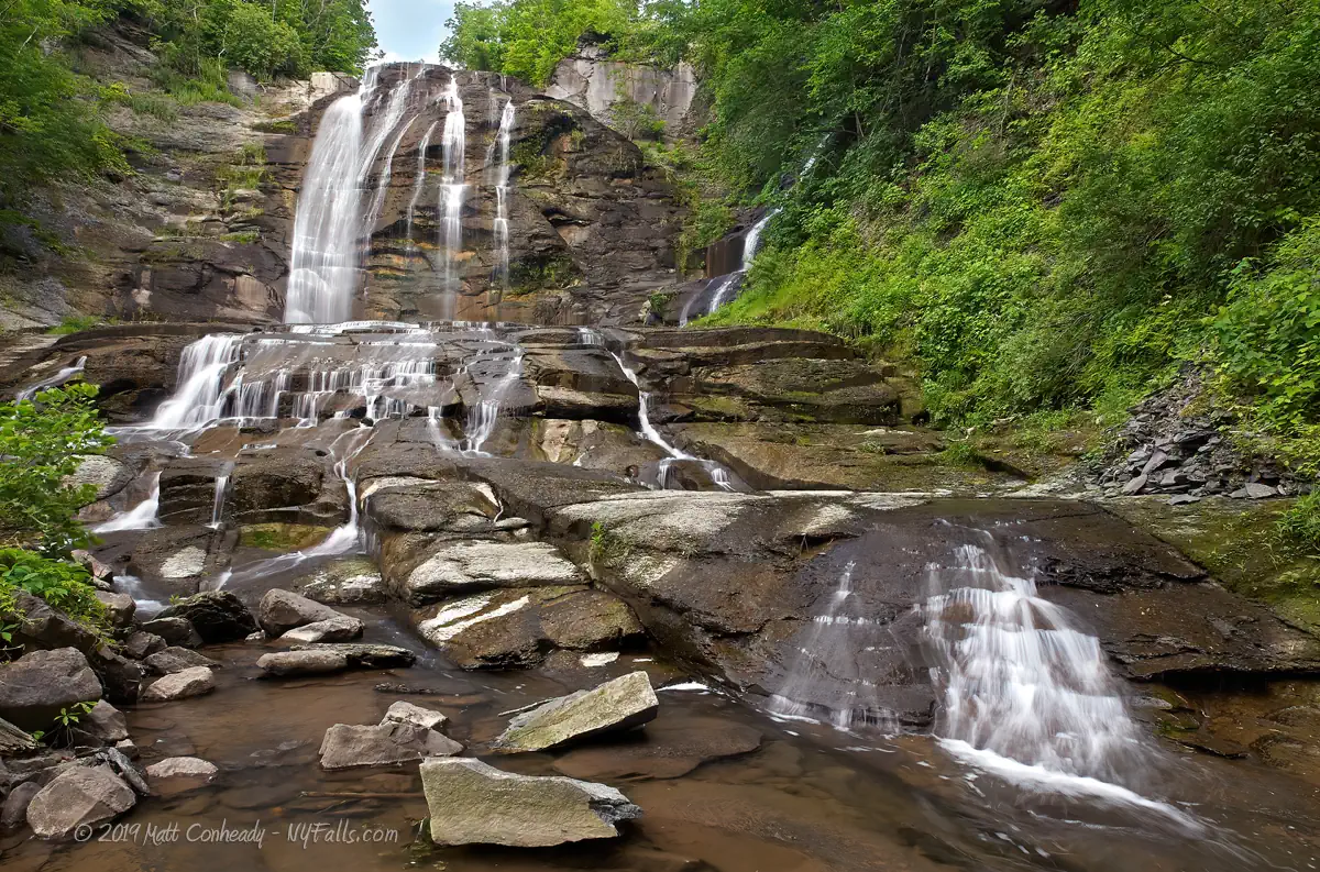
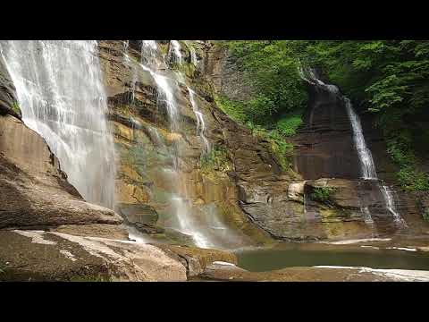
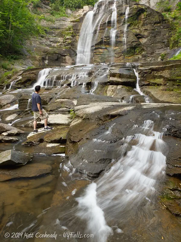
Montville Falls one large waterfall that takes about a 60 ft plunge in numerous crevices down a solid rock face. It also splits off near the crest forming a “Twin Falls” on the right-hand side of it that comes down through the forest before joining again at the bottom. Then it continues down numerous cascades about 14 ft before leveling out into the gorge. The rock on Montville Falls is decidedly different than most of the other falls in the Finger Lakes area. It is a harder rock (limestone), much more sturdy that gives the waterfall a distinct look. There’s a dam up top which limits the flow, which is why the water doesn’t completely flood the face of it. If it does, you won’t see it as you will be drowned and floating downstream in a torrent of muddy water.
Best time to visit: Spring or fall. After heavy rain.
Flow: Low, but variable. Flow is regulated by an upstream dam and power plant, which often brings it to a trickle.
Waterway: Montville is on Dresserville Creek, which combines with Decker Creek to become Mill Creek. Mill Creek then joins Hemlock Creek, which is the inlet to Owasco Lake.
Time: 40 minutes to an hour.
Seasons/Hours: Whenever you can get access, which as of Spring 2010, is when the cemetery is open. We do not have the cemetery hours at this time. Do not park in the cemetery.
Admission: No fees.
Handicap accessibility: No.
Pets: We are not sure, but don’t bring your pet on dangerous hikes – they are not climbers. Be a responsible owner.
Accommodations: None.
Description
Aka: Moravia Falls
The combination hike of these Mill Creek tributaries will get you close to these two falls – Decker Creek Falls and the massive 75 ft Montville Falls (if it is flowing at the time).
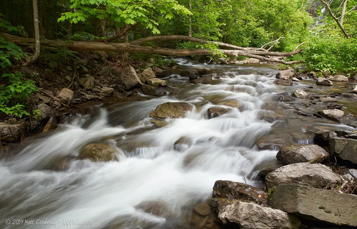
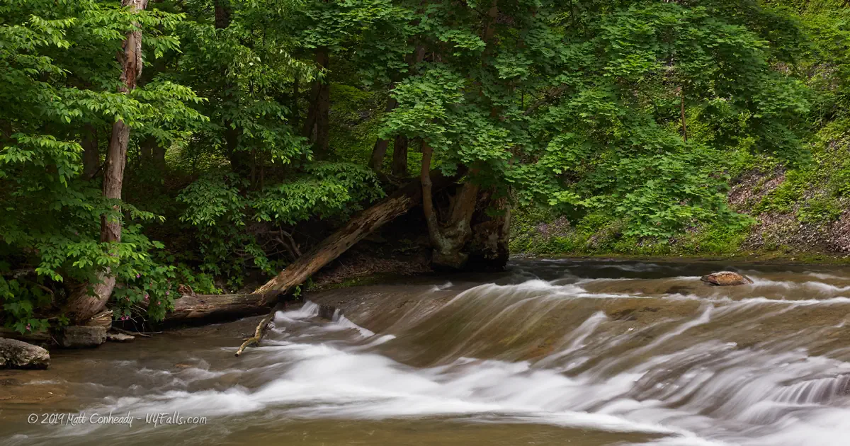
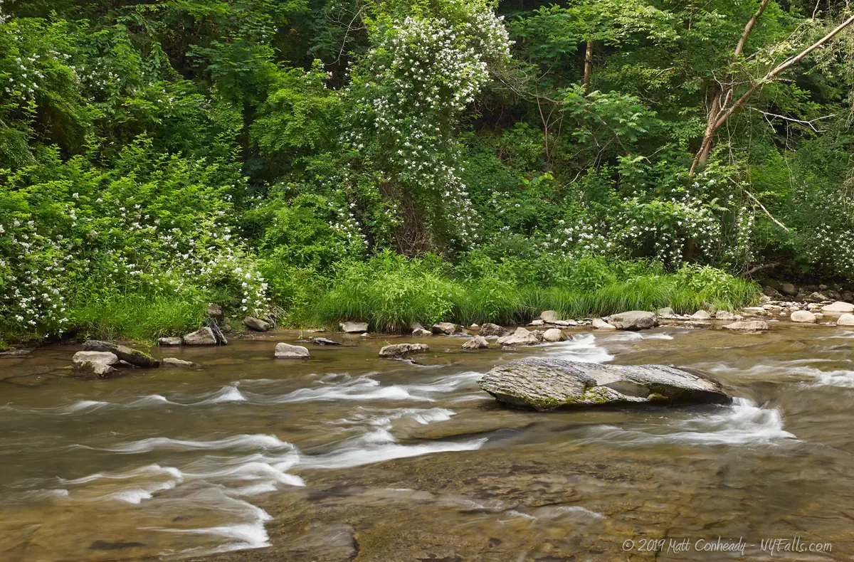
Decker Creek Falls consists of two small limestone cascades, are a nice treat in this rarely-accessed slice of wilderness. The falls, one 9 ft and the other 6, are right next to each other and surrounded by thick, peaceful forest. The limestone bedrock here evens out the boulder-spotted creek bed and gives the waterfalls a step-like structure. The falls are of decent size and sometimes flowing even if neighboring Montville Falls isn’t. The natural setting in the small gorge is nice as a distraction if you are in the area, and certainly worth it if you are here to see the larger Montville Falls, but they are certainly not worth going out of your way for.
Upstream from these two falls are numerous other drops, but they are reportedly all on private property. If you see a POSTED sign, turn around.
Montville Falls has a character quite unlike the rest of the Finger Lakes watershed waterfalls. It is a wild waterfall with no defined trails or accommodations, set in a beautifully wooded gorge in the heart of the Owasco Lake watershed. Composed of hard limestone rock, the water erodes the stone along cracks in the bedrock, creating geometric angles that give this waterfall a distinct appearance.
The great thing about this waterfall is the difference the level of water makes. Varying between multiple small ribbons winding around the rock in low flow to an even downpour when the water is high, Montville Falls is worth the trek in multiple seasons if it is accessible.

History
Near where Montville Falls is located, along Mill Creek, a man named Jethro Woods invented the first cast iron plow in 1819, drastically increasing the productivity of farmers and the reliability of their equipment. Unfortunately for Woods, he had to fight patent infringements his whole life and died a poor man. Montville was once a large manufacturing center, using the power of Mill Creek to build numerous factories along its banks. It rivaled the village of Moravia for dominance until the mills began to close along the creek as electric power ushered in modern industry.
An 1875 map shows “E. S. Baker Sawmill and Stave Factory” on the site of Decker Creek Falls.

Hiking / Walking Trails
Be aware: I have received multiple reports denying access to parking, the creek, the cemetery and the falls. I have not checked these reports personally, because I live quite a ways away. It’s up to you to obey the law, and if you do not, I take no responsibility for your personal decision. Obey POSTED signs.
Difficulty: Moderate to difficult (depending on water flow).
Markings: None.
Distance: 3/4 mile (one-way) to visit Decker Creek and Montville Falls.
Hiking upstream at less than a mile, you will reach a fork. To the right, Dresserville Creek and Montville Falls, to the left is Decker Creek Falls. Hike left for 900 feet or so to get there.
Map: Interactive.


Decker Creek & Moravia Falls Interactive Map
Montville Falls Media
Interesting Stuff
The cemeteries
If you have the time, explore and photograph the cemeteries, Indian Mound and St. Patricks, which have grave stones dating back to 1817.
Fillmore Glen State Park
Located south of the village, this state park features a massive gorge with several waterfalls.
Photography Tips
Use caution
- The rocks can get quite slippery in the creek. Use water shoes with a good grip and use a walking stick or your tripod to keep balance.
- Keep your camera well-protected. Seal it in a waterproof bag when you are hiking in high water levels.
The creek
- Don’t just photograph the falls. The many twists and turns in the creek flow, with the large boulders make for interesting shots.
Overcast skies
- Daylight will cast uneven shadows and the late sun will leave it in the shade. It is best to wait for an overcast sky for this one.
Silky Water Effect
- To get that smooth cotton-candy look to the falls, you need to use a Neutral Density (ND) filter on your lens. The ND filter will block some of the light from entering the lens without altering the color, and thus allow your shutter to stay open longer. This blurs the water and creates a soft white gloss to the foamy areas of the falls. Check out the article for the all the details.
More tips
- See the Articles for more photography tips.
Who to Contact
Town of Moravia
139 Main Street Moravia, NY
Phone number: (315) 497-1972
E-mail: [email protected]
