
Carpenter Falls (Bahar Nature Preserve)


Location: On the west side of Skaneateles Lake; Directly north of the Village of New Hope; Town of Niles; Cayuga County; New York
Maps: Google Map, Topographic; Trail map; Interactive map;
GPS Coordinates:
- Parking lot: N 42.81333 / W 76.34142
- Carpenter Falls: N 42.81174 / W 76.34309
- Angel Falls: N 42.81779 / W 76.33837
Directions: From Rt 20 in Skaneateles, head south on Rt 41A for about 8 miles. After Derby Rd on your right, will be Appletree Point Rd on your left. Turn down Appletree Point Rd and follow it for a quarter mile to the junction with Carver Rd. Park in the small lot.
From Cortland and points south, take Rt 41 north for 2 miles to Rt 41A. Head north on 41A for roughly 30 minutes. Just past the junction with CR 66A make a right onto Appletree Point Rd. Follow it for a quarter mile to the junction with Carver Rd.
Or use Google Directions.
Parking: Park at the junction of Appletree Point Rd and Carver Rd. There is a paved ecco-lot with space for about 12 cars. Additional parking is roadside along Appletree Point Rd. There is no parking at the shore, but you may be able to squeeze in on the side of Appletree Point Rd very close to it.

Weather
Information / Accessibility / Accommodations
Number of falls: 4, of which 2 are directly accessible. Some smaller drops as well.
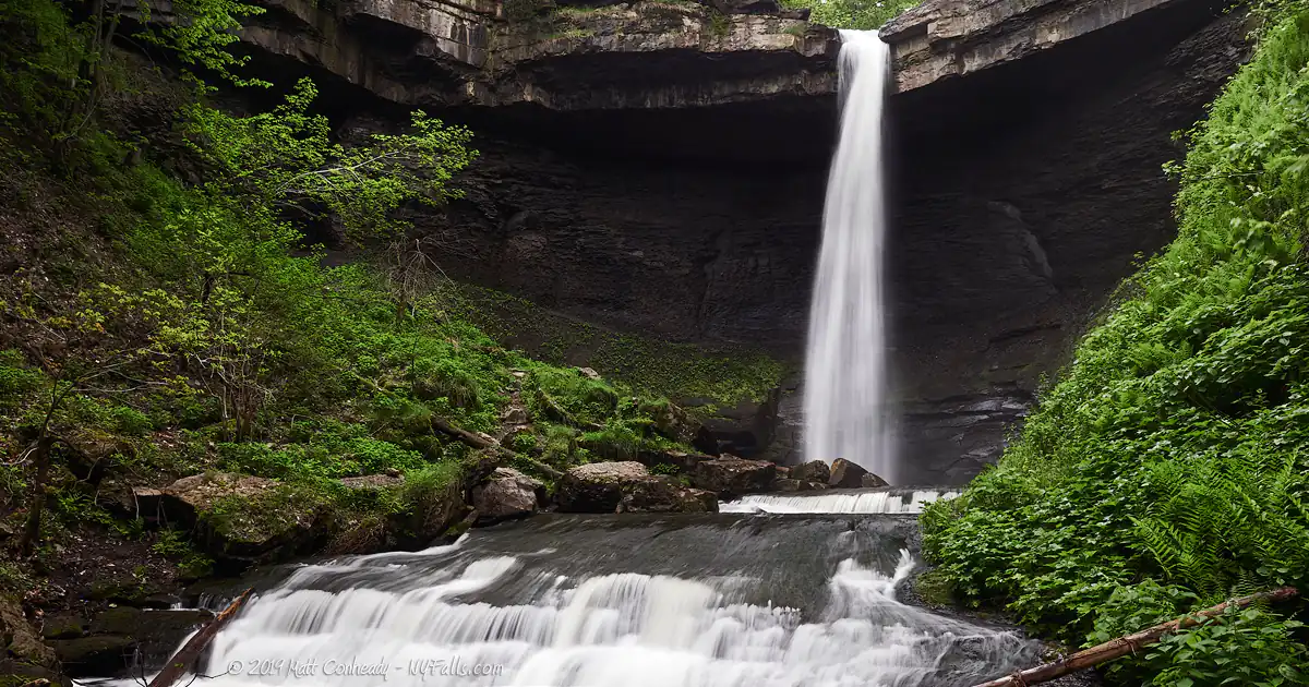
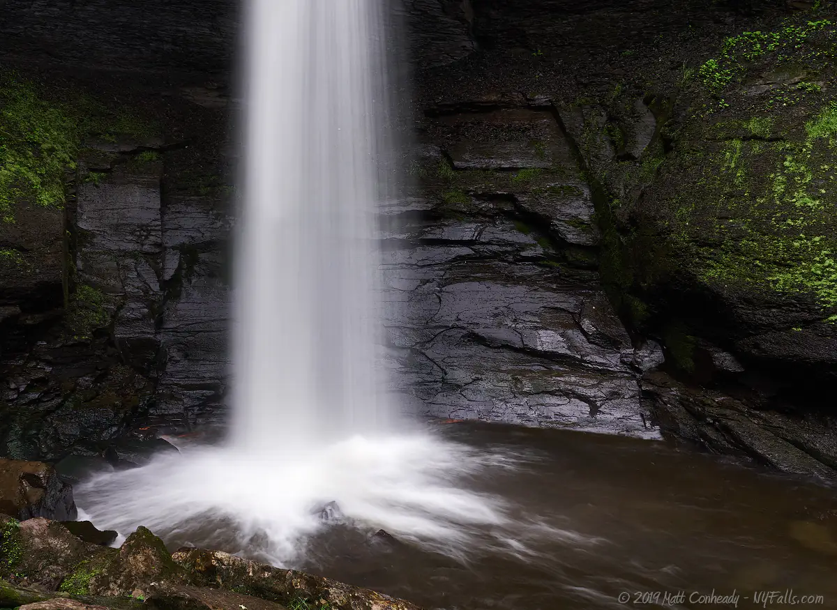
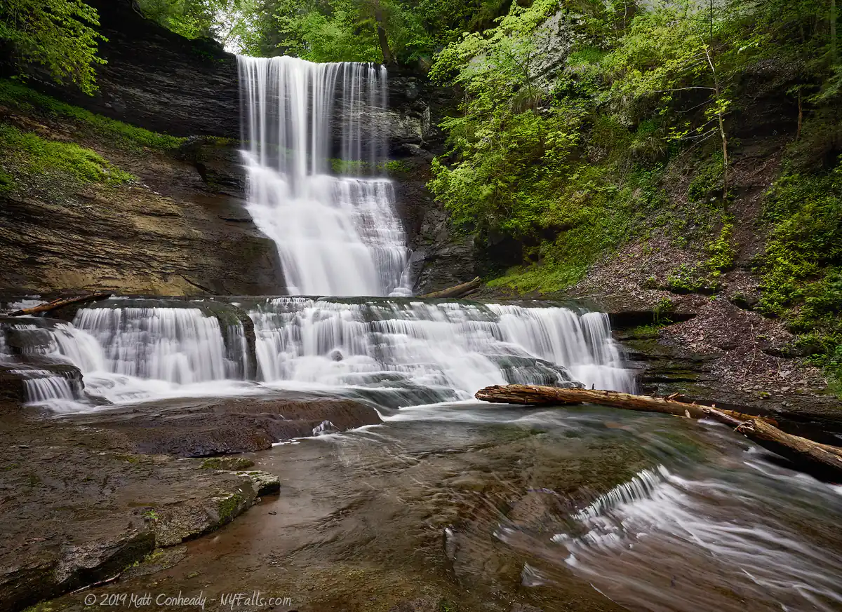
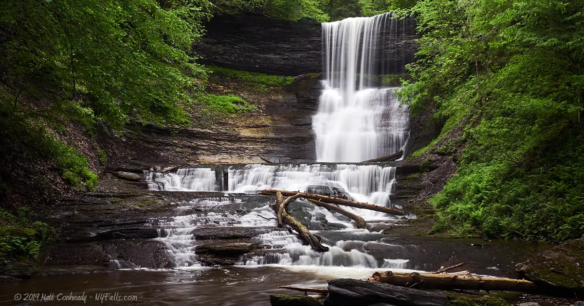
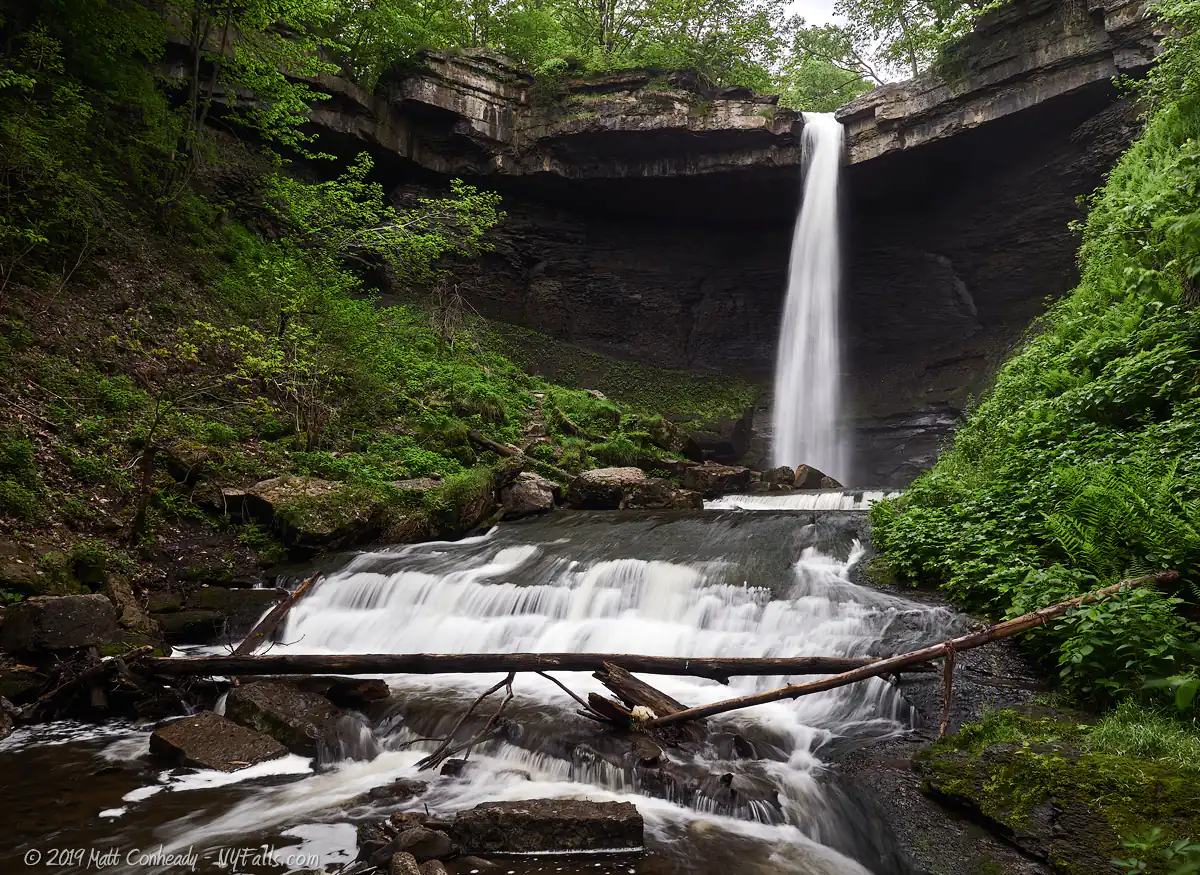
Size/Types: Carpenter Falls reaches 90 ft tall. It falls as a powerful ribbon that cuts through a notch in the massive overhanging limestone caprock, and plunges over 80 feet into a deep pool. Using caution, one can walk right behind the falls.
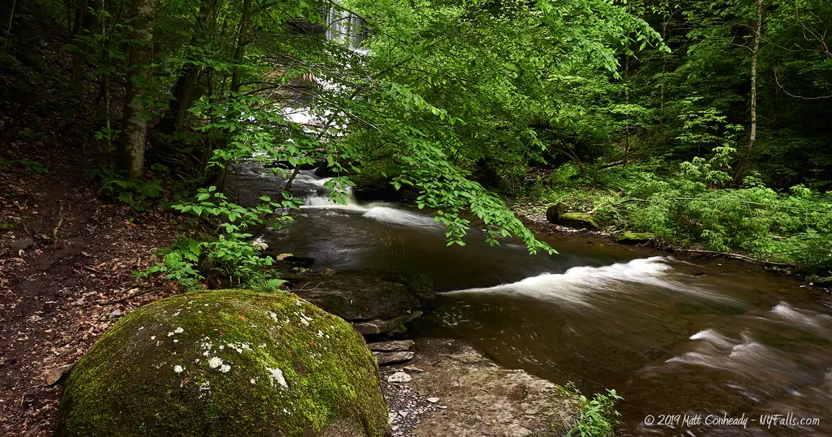
The second waterfall is a sloping cascade, roughly 20 ft high and finished with a refreshing pool.
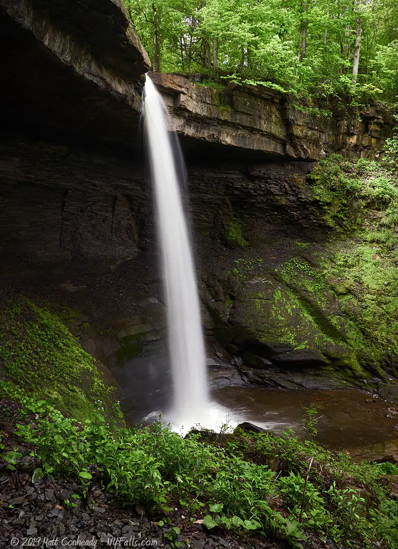
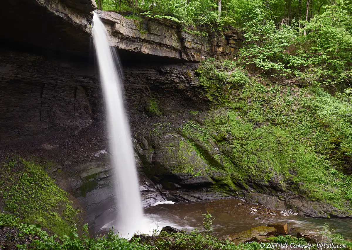
Angel Falls is a 62 ft overhanging drop and cascade (similar to Tinker Falls). It starts as an overhanging ribbon that hits the rock below and cascades the rest of the way. A deep pool at the base is a popular spot for swimming.
A final cascade reaches roughly 11 ft tall.
Best time to visit: Spring through fall. Although fresh rain allows for better flow, it makes the climbs more dangerous and creek-walking more difficult.
Flow: Variable; it is usually flowing, but highly dependent on rain and melt-water.
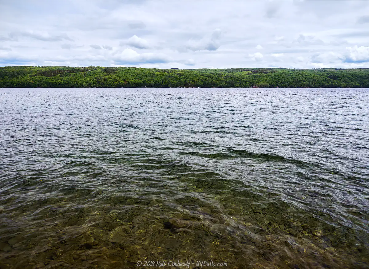
Waterway: Bear Swamp Creek, a tributary to Skaneateles Lake.
Time: You can get a decent view of Carpenter Falls from the top in just 10 to 15 minutes. If you want to make your way down the gorge to wind up at the lake, plan for at least an afternoon. Allow yourself enough light.
Seasons/Hours: Open year-round, all day.
Admission: Free.
Handicap accessibility: No.
Pets: Allowed if on a leash. For your pet’s safety, and the safety of other hikers, keep your pet on the leash! There has been at least one recent instance of a pup slipping and getting seriously hurt. Just play it safe! Dogs are not good climbers.
Swimming: Those refreshing pools below the falls are hard to resist. Officially, hanging out in the water is not allowed, but commonly done. Use extreme caution as the water can get murky and the flow is unpredictable at times. Swimming at the lake is prohibited. Do not jump from the top of Carpenter Falls! You will die.
Accommodations: Signs, restrooms, bicycle rack, maps, parking, hiking trails, fishing, hand boat launch on Skanteateles Lake.
Description
AKA: Carpenter’s Falls, Carpenter Falls unique Area, Angel Falls, Bear Swamp Cascades
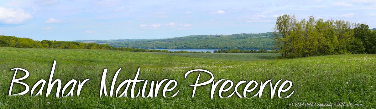
Tucked away along the southwest end of Skaneateles Lake, among the vast stretches of cultivated fields in the Skaneateles Highlands, is a little slice of exhilarating wilderness, protected and waiting for you to explore. Although many in the region have heard of or seen pictures of Carpenter Falls, only a small sample have explored further down the Bear Creek Swamp gorge to the several other waterfalls and eventually reach the rewarding view found at the Skaneateles lakeshore.
Carpenter Falls is a massive ninety foot waterfall that has carved a notch out of the shelf-like caprock, from which it takes a powerful plunge down crashing into a deep, round pool, frequented by bathers on hot summer days. The more adventurous can shuffle down the steep gorge trail along the southern rim, and check out several other waterfalls, including Angel Falls, a picturesque sixty foot waterfall that begins as a wide ribbon-plunge and ends up cascading over smaller gradual ledges. It really is a powerful, yet peaceful experience to be in this section of the gorge, that is when rowdy visitors aren’t dangerously dangling off the cliff edge and shouting for their Instagram stories.
Continuing the hike offers glimpses through the thick forest canopy towards the strikingly blue waters of Skaneateles Lake, considered one of the cleanest lakes in the state of New York. A challenging venture onward (and downward) will get you to the Skaneateles shoreline and a spectacular vista. The shoreline is also reachable by road and can be used as a hand boat launch site, for fishing, bird-watching, or for those looking for a workout, a climb upstream.
Special Thanks to Matt Champlin for his help building this page.
History
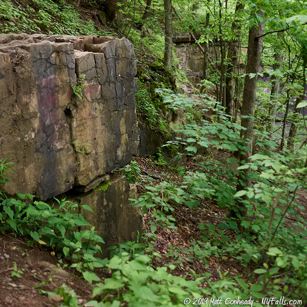
Evidence of an old mill can be found in the form of the remnants of a sluiceway dug above Carpenter Falls between the parking area and the falls. In 1820, James Carpenter settled here with his son John H. Carpenter and operated a saw mill, planing mill, shingle mill, and cheese box factory along the falls. John operated a still near the site, and later a grist mill (which then converted to a saw mill).
At one time Warren S. Clark operated a cider mill along the creek.
The trail that runs down the gorge rim is referred to as “Old Jug Path,” supposedly for the old dirt road it traces. It is believed that a distillery once stood along the creek somewhere between Carpenter Falls and the shoreline (we are not sure exactly where) and took advantage of its seclusion in the gorge for privacy, as well as access to the landing on the lake for distribution, allowing it to prosper during Prohibition.
A significant portion of the gorge was safe in the hands of nature-lover Hu Bahar and his family. After his death, in an effort to secure the preservation of the land, his widow Dawn generously sold 25 acres to the Finger Lakes Land Trust at a reduced cost in 1998 and the Bahar Nature Preserve was established. The Land Trust aggressively sought out adjoining parcels to save them from development, purchasing another 33 acres in 2005 and then another 29 acres in 2007. Totaling 87 acres, this mix of lake watershed, filled with immature mixed and coniferous forest, steep rocky cliffs, a fragmented trail system and a sliver of a beach is a lot to manage. So in 2008 the Land Trust transferred management of 36 acres of the western-half of the property to the New York State Department of Environmental Conservation (NYSDEC). The uplands, together with Carpenter and Angel Falls are included in this segment, in what is now called the Carpenter’s Falls Unique Area. Most notably, the state maintains the rim trail (Old Jug Path), the parking area, and the informational signage. In 2022 the completion of a $1.27 improvement project added the Accessible boardwalk to the a new upper falls viewing platform, paved parking lot, bike rack, toilet, and stone steps leading to a viewing area at the base of the upper falls.
Hiking / Walking Trails
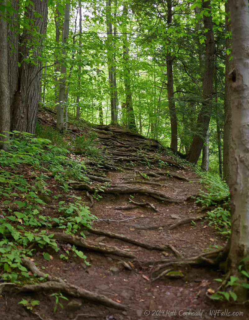
Difficulty: Easy to see Carpenter Falls from the top. Very difficult to get to the rest of the falls.
Distance: Just over a mile one way.
Markings: The trailhead is marked. The rim trail (Old Jug Path) is a well-defined and marked gravel and dirt trail. From the parking area to the observation platform upstream to the left is elevated wooden plank, suitable for wheelchair access.
Heading downhill and downstream is a bit rougher and not accessible to chairs, but much improved over the primitive trail that was here prior to 2022. The offshoots to the creek bed below the falls are not marked, but can be found if you are looking hard enough.
Trail Guide:
- From the parking area and the informational sign, head west along the wood boardwalk trail (you should begin to hear Carpenter Falls) and should reach a nice spot to view it from in about a 10th of a mile. Around this area is a stone steps leading to a viewing area below the upper falls.
- You can continue along the trail to where it reaches the creek bed above the falls (near the road) and you can follow it briefly downstream to the very crest to enjoy a spectacular view of the amphitheater-like gorge.
- Turn around and head back along the same trail. You now have a few options.
- You can continue down this trail (Old Jug Path) for about a mile taking steep, unmarked branches to get to the bottoms of the remaining falls, and then coming back up to the trail and continuing all the way to the lake.
- Or you can take one of the branches down just below Carpenter Falls, and explore the creek from there, climbing down a 20 foot falls downstream and ending up at the crest of Angel Falls. To get to the bottom of Angel Falls and then the final 11 ft waterfall, you will have to climb a steep trail back up to the main Jug Path and then back down another branch further down. Note that hiking down into the gorge is not an official trail, possible prohibited and dangerous. Proceed at your own risk.
- If you make it to the shore of Skaneateles Lake, you can take the winding Appletree Point Rd back up to the parking area for a loop or head back up the way you came.
- There are so many unmarked branches (many of which are steep climbs where rope is almost necessary) that we recommend you take care in navigating and traversing the preserve. Keep safe and don’t get lost. Our interactive map below plots the major routes over a satellite view of the gorge.
Maps: Trail map; See the interactive map below
Carpenter Falls Interactive Map
Carpenter Falls Media
Carpenter Falls Videos

Interesting Stuff
Carpenter or Carpenter’s
Officially, the name is Carpenter—without the apostrophe, as recorded and published by the USGS. Although many names of places, landmarks and especially waterfalls were first named in the possessive after their founders or owners, the USGS commonly removed the apostrophes when recording locations in order to avoid indicating any property ownership in their official maps and reports. This was not much of a big deal, because by the time the USGS was mapping and labeling details such as waterfalls, ties to their namesakes had long since been forgotten. The possessive versions of the names still remain in literature and on the tongues of locals. The Finger Lakes Land Trust, the stewards of this preserve, refer to the falls as Carpenter’s as does the State DEC. But in the age of the internet, the apostrophe and the “s” matter little. Googling either yields the same results.
Birding
Bring those binoculars. The National Audubon Society has classified this preserve as an important birding area.
Photography Tips
Carpenter Falls
- …is relatively easy to get framed from the top of the Old Jug Path. Since it is out in the open, mid-afternoon sunlight can wash out shots, it’s best to shoot on overcast days.
Angel Falls
- …is covered in with a thick forest canopy and shielded by the towering gorge walls. It may be possible to get even lighting here even on bright, sunny days.
Behind the Falls
- With caution, you can climb behind Carpenter or Angel Falls for some interesting angles.
Keep your gear safe and dry
- The difficult hike may get you dirty and wet. Be sure to protect your gear in case of a fall.
Silky Water Effect
- To get that smooth cotton-candy look to the falls, you need to use a Neutral Density (ND) filter on your lens. The ND filter will block some of the light from entering the lens without altering the color, and thus allow your shutter to stay open longer. This blurs the water and creates a soft white gloss to the foamy areas of the falls. Check out the article for the all the details.
More tips
- See the Articles for more photography tips.

Who to Contact
Finger Lakes Land Trust
202 East Court Street
Ithaca, NY 14850
Phone: (607) 275-9487
e-mail: [email protected]
web: fllt.org
NYSDEC Region 7
615 Erie Blvd.
Syracuse, NY 13204
Phone: (315) 426-7400
Web: dec.ny.gov
